Garmin
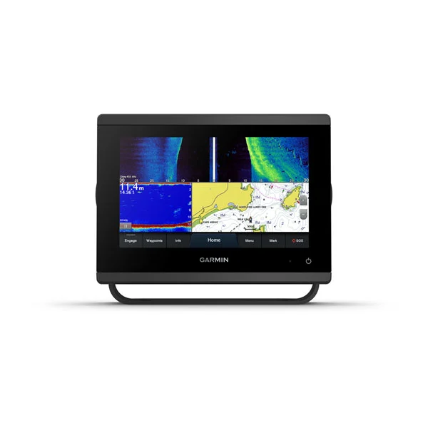
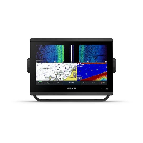
GPSMAP® 743xsv, 943xsv, 1243xsv Chartplotters SideVü, ClearVü and Traditional CHIRP Sonar with Worldwide Basemap and Mapping
GPSMAP® 743xsv, 943xsv, 1243xsv Chartplotters SideVü, ClearVü and Traditional CHIRP Sonar with Worldwide Basemap and Mapping
Couldn't load pickup availability
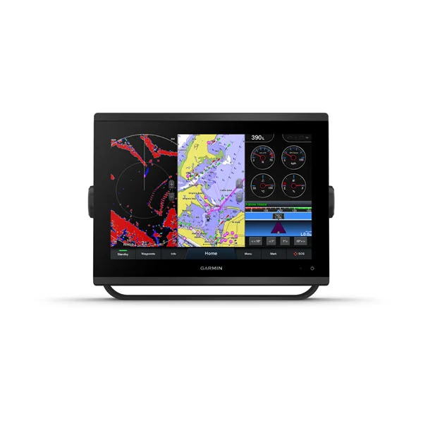
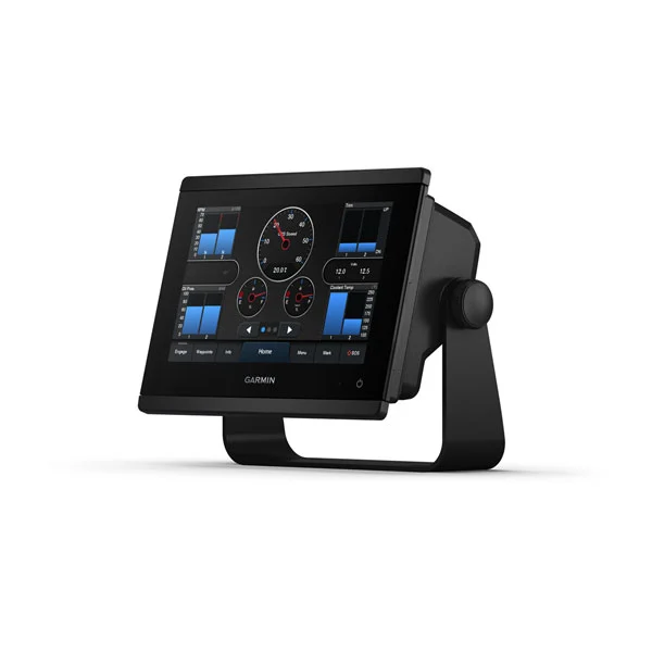
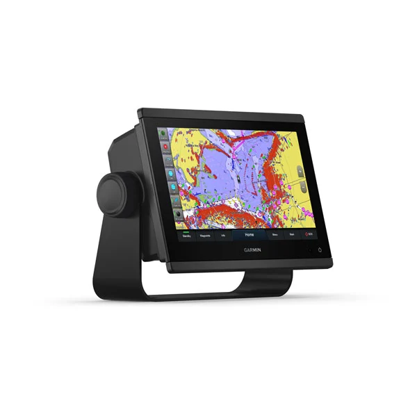
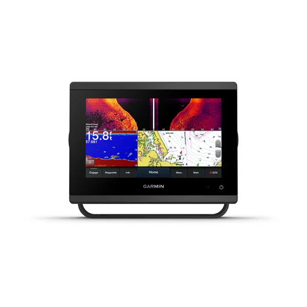
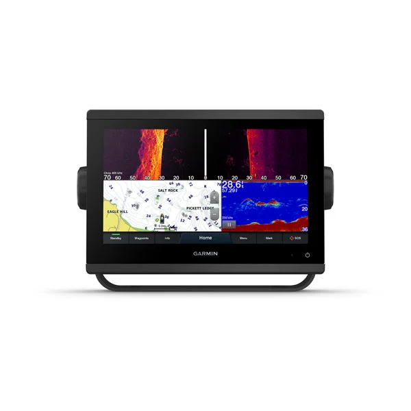
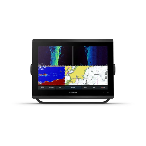
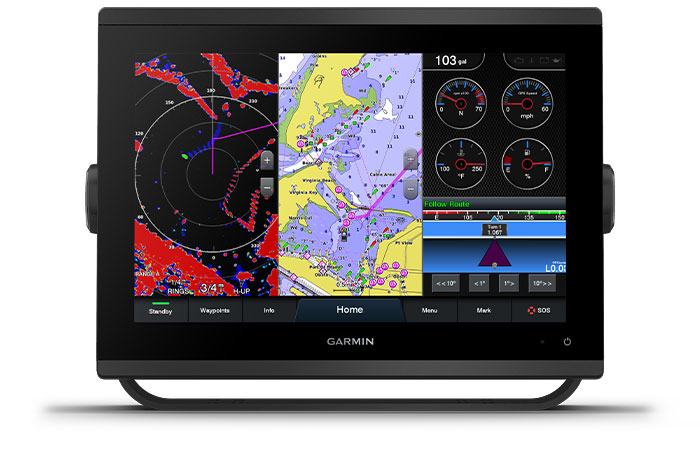
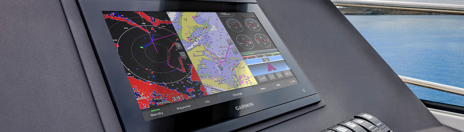
GET A SHARPER VIEW FROM YOUR CONNECTED HELM
With 60% more display pixels and nearly double the processing power of previous-generation 7” GPSMAP devices, this crisp high-resolution chartplotter integrates seamlessly into your Garmin marine system.
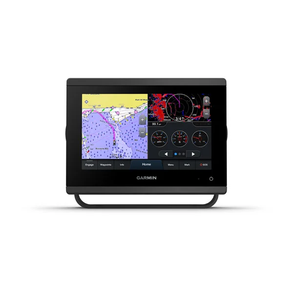
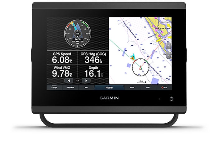
Sail and navigate with ease.

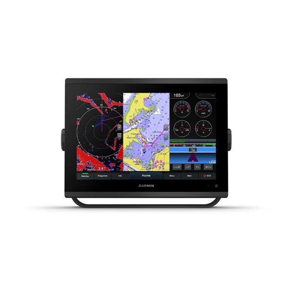
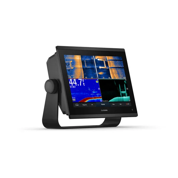
FAST, SHARP, SMART:
With its powerful technology and new slimline design featuring edge-to-edge glass and a smaller unit footprint, it’s easy to retrofit this 12” plotter in a wider range of dash configurations.
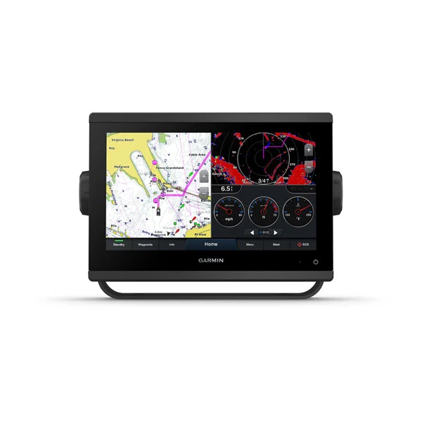
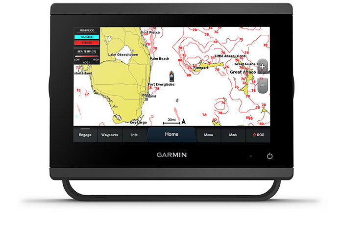
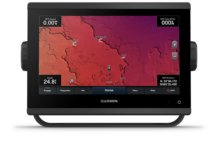
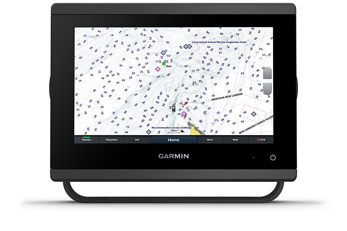
PRELOADED MAPPING:
Experience unparalleled coverage and detail with preloaded BlueChart® g3 coastal charts and LakeVü g3 inland maps featuring integrated Garmin and Navionics® content and Auto Guidance2 technology.
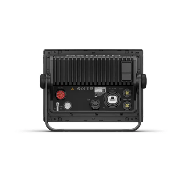
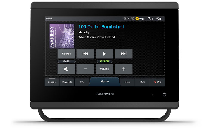
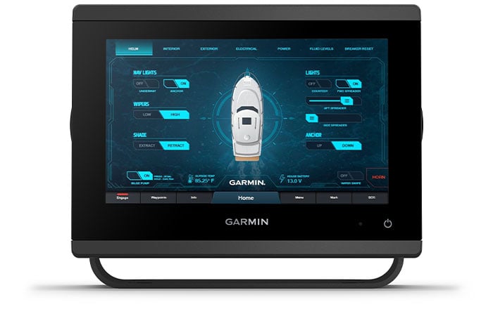
Connect to everything on your boat.
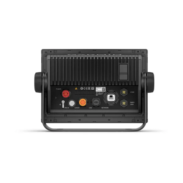
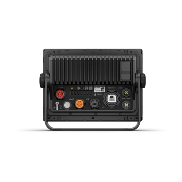
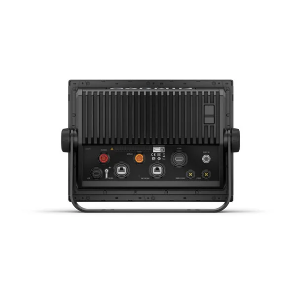
GARMIN MARINE NETWORK:
If you have multiple compatible Garmin devices on your boat, you can share information — such as maps, user data, radar and IP camera video — among them.
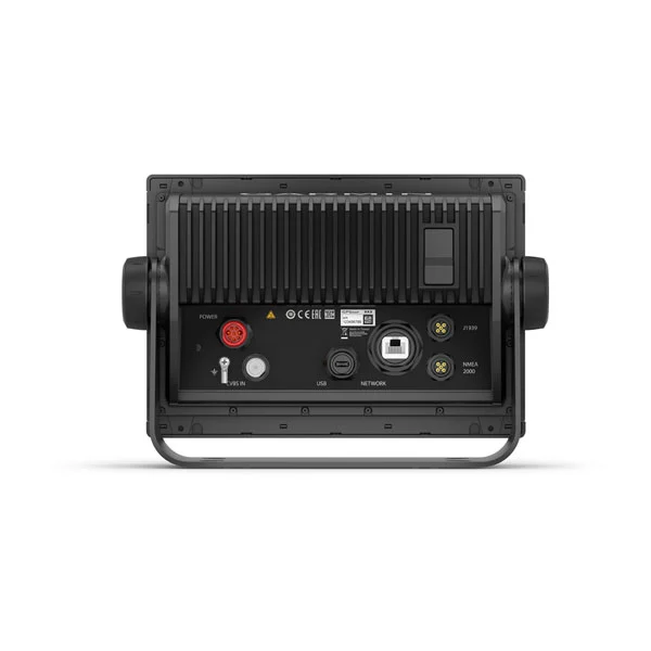
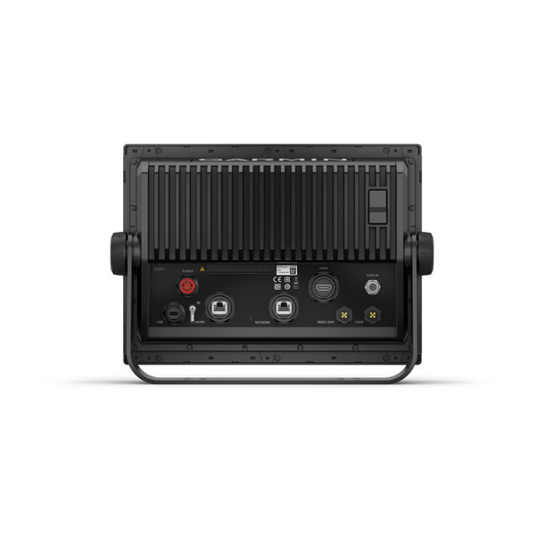
NMEA 2000® AND NMEA 0183 NETWORKS:
Connect to compatible autopilots, digital switching, weather, Fusion-Link™ audio system, media, VHF, AIS and more from one screen.
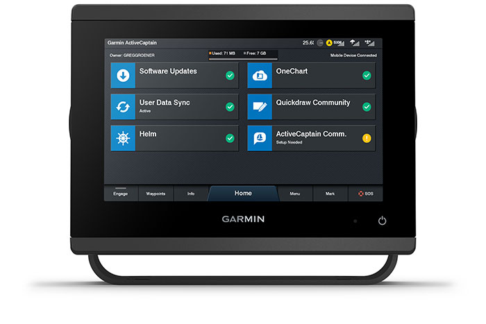
ACTIVECAPTAIN® APP:
Built-in Wi-Fi® connectivity pairs with the free all-in-one mobile app for access to the OneChart™ feature, smart notifications2, software updates, Garmin Helm™ digital switching, Garmin Quickdraw™ Community data and more5.
INTEGRATED ANT® TECHNOLOGY:
Connect with some of your favorite devices, such as quatix® marine watches, gWind™ Wireless 2 transducers, GNX™ Wind marine instruments and wireless remote controls.
J1939 CONNECTIVITY:
Now you can connect your chartplotter to different kinds of engines, including select Yamaha engines.
ONEHELM FEATURE:
This exclusive feature brings together all the operations and capabilities of select third-party devices, such as EmpirBus™ digital switching, on one screen.
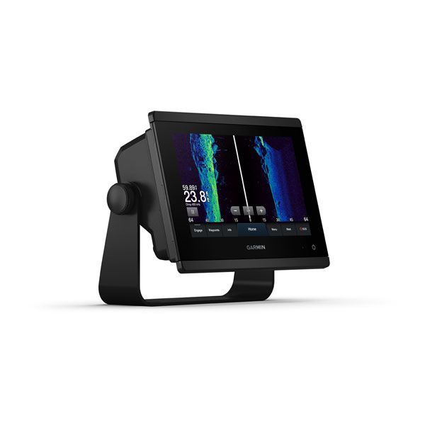
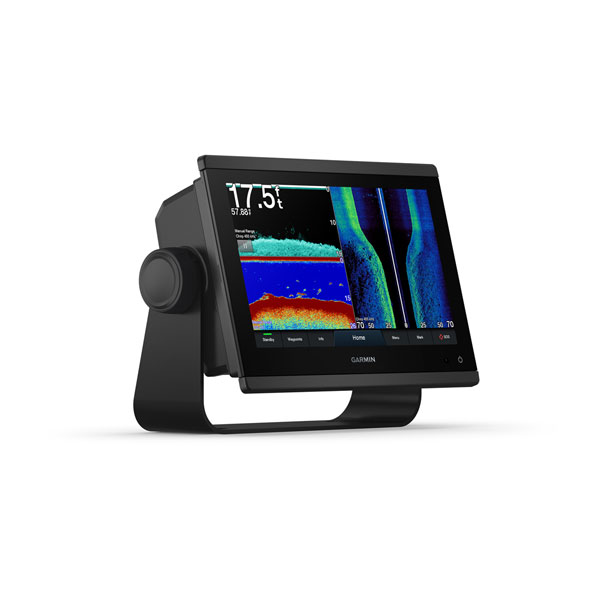
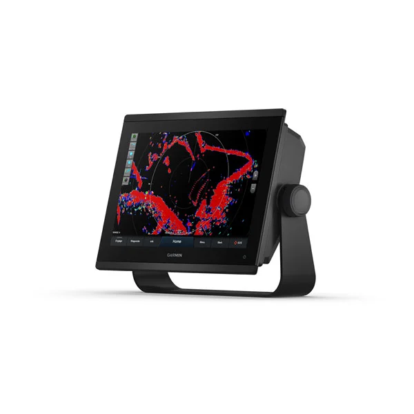
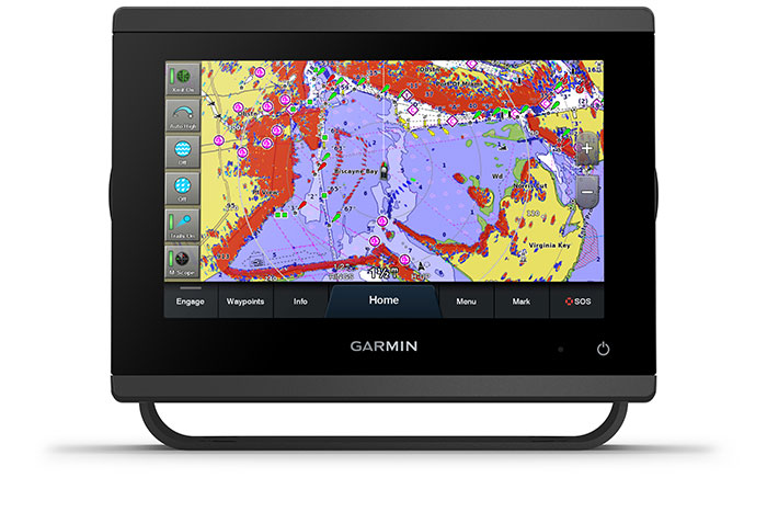
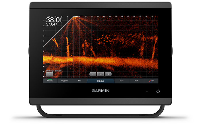
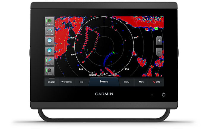
See the world below.

PANOPTIX™ SONAR SUPPORT:
Pair with Panoptix PS51 (transducer sold separately) with FrontVü scanning sonar6 to help you see and avoid submerged obstacles in real time as you approach within a 300’ range.
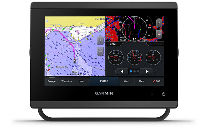
OPTIONAL BLUECHART® G3 VISION® CHARTS:
Upgrade to our reliable premium charts,3 which add even more unparalleled features, such as high-resolution relief shading, to help you on each trip.
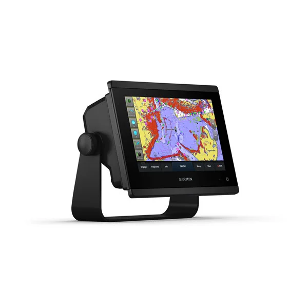
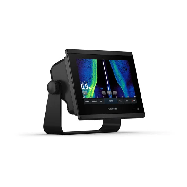
FASTER, SHARPER, SMARTER:
With its added processing power and new slimline design featuring edge-to-edge glass and a smaller unit footprint, it’s easy to retrofit this 7” plotter in a wider range of dash configurations.
IMPROVED DISPLAY OPTICS:
New higher-resolution 7” displays offer improved sunlight readability with 60% more pixels than previous-generation 7” GPSMAP devices.
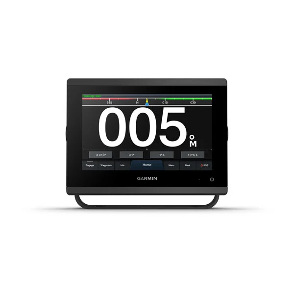
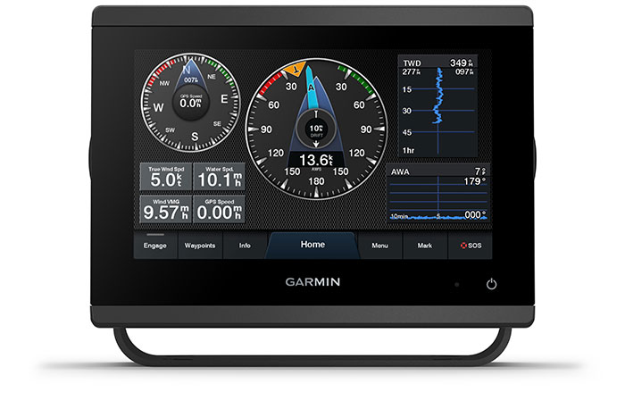
GARMIN SAILASSIST™ SAILING FEATURES:
View laylines, race start line guidance, enhanced wind rose, heading and course-over-ground lines, true wind data fields and tide/current/time slider, wind angle, set and drift, wind speed and more3.
OPTIONAL BLUECHART® G3 VISION® CHARTS:
These optional charts offer the best of Garmin and Navionics® data, Auto Guidance4 technology and other premium navigation features.
GPSMAP® 723 7" Non-sonar with Worldwide Basemap:
General:
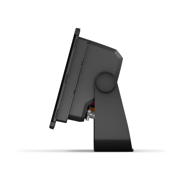
- PHYSICAL DIMENSIONS 7.6" x 5.5" x 2.9" (19.2 x 14.0 x 7.4 cm)
- DISPLAY SIZE 6.1" x 3.5"; 7.0" diagonal
- (15.4 x 9.1 cm; 17.8 cm diagonal)
- DISPLAY RESOLUTION 1024 x 600 pixels
- DISPLAY TYPE WSVGA display
- WEIGHT 2.8 lbs (1.3 kg)
- WATER RATING IPX7
- MOUNTING OPTIONS Bail, flush or flat
- POLARIZED SUPPORT
- POWER CONSUMPTION
- Max power usage at 10 Vdc: 17.6 W
- Typical current draw at 12 Vdc: 1.1 A
- Max current draw at 12 Vdc: 1.5 A
- ANTENNA Internal or external over NMEA 2000
- RECEIVER 10 Hz high-sensitivity
- GARMIN MARINE NETWORK™ PORTS 1
Maps & Memory:
- PRELOADED MAPS worldwide basemap
- ACCEPTS DATA CARDS 2 microSD™ cards (back of unit)
- WAYPOINTS 5,000
- TRACK LOG 50,000 points; 50 saved tracks
- ROUTES 100
Outdoor Recreation:
- TIDE TABLES
- GARMIN RADAR COMPATIBLE
- GARMIN SONAR COMPATIBLE (with external black box, sold separately)
- GARMIN SMARTMODE COMPATIBLE (CUSTOMIZABLE MONITOR PRESETS)
- SUPPORTS AIS (TRACKS TARGET SHIPS POSITION)
- SUPPORTS DSC (DISPLAYS POSITION DATA FROM DSC-CAPABLE VHF RADIO)
- SUPPORTS FUSION-LINK™ COMPATIBLE RADIOS
- GSD™ BLACK BOX SONAR SUPPORT
- GCV™ BLACK BOX SONAR SUPPORT
- ACTIVECAPTAIN COMPATIBLE
- WIRELESS REMOTE COMPATIBLE
- CLEARVÜ Yes (with external black box, sold separately)
- NMEA 2000® COMPATIBLE
- NMEA 0183 INPUT PORTS 1 (Differential)
- NMEA 0183 OUTPUT PORTS 1 (Differential)
- WIRELESS CONNECTIVITY
- J1939 COMPATIBLE
- USB port: 1
GPSMAP® 923 9" Non-sonar with Worldwide Basemap:
General:
- PHYSICAL DIMENSIONS 9.2" x 6.4" x 3" (23.3 x 16.2 x 7.6 cm)
- DISPLAY SIZE 7.8" x 4.4"; 9.0" diagonal
- (19.9 x 11.2 cm; 22.9 cm diagonal)
- DISPLAY RESOLUTION 1280 x 720 pixels
- DISPLAY TYPE WXGA IPS display
- WEIGHT 3.6 lbs (1.6 kg)
- WATER RATING IPX7
- MOUNTING OPTIONS Bail, flush or flat
- POLARIZED SUPPORT
- POWER CONSUMPTION
- Max power usage at 10 Vdc: 22 W
- Typical current draw at 12 Vdc: 1.3 A
- Max current draw at 12 Vdc: 1.8 A
- ANTENNA Internal or external over NMEA 2000
- RECEIVER 10 Hz high-sensitivity
- GARMIN MARINE NETWORK™ PORTS 1
Maps & Memory:
- PRELOADED MAPS worldwide basemap
- ACCEPTS DATA CARDS 2 microSD™ cards (back of unit)
- WAYPOINTS 5,000
- TRACK LOG 50,000 points; 50 saved tracks
- ROUTES 100
Outdoor Recreation:
- TIDE TABLES
Chartplotter Features:
- GARMIN RADAR COMPATIBLE
- GARMIN SONAR COMPATIBLE (with external black box, sold separately)
- GARMIN SMARTMODE COMPATIBLE (CUSTOMIZABLE MONITOR PRESETS)
- SUPPORTS AIS (TRACKS TARGET SHIPS POSITION)
- SUPPORTS DSC (DISPLAYS POSITION DATA FROM DSC-CAPABLE VHF RADIO)
- SUPPORTS FUSION-LINK™ COMPATIBLE RADIOS
- GSD™ BLACK BOX SONAR SUPPORT
- GCV™ BLACK BOX SONAR SUPPORT
- ACTIVECAPTAIN COMPATIBLE
- WIRELESS REMOTE COMPATIBLE
Sonar Features & Specifications:
- CLEARVÜ Yes (with external black box, sold separately)
Connections:
- NMEA 2000® COMPATIBLE
- NMEA 0183 INPUT PORTS 1 (Differential)
- NMEA 0183 OUTPUT PORTS 1 (Differential)
- WIRELESS CONNECTIVITY
- J1939 COMPATIBLE
Additional:
- USB port: 1
GPSMAP® 1223 12" Non-sonar with Worldwide Basemap:
General:
- PHYSICAL DIMENSIONS 12.1” x 8.9” x 3.2” (30.8 x 22.8 x 8.2 cm)
- DISPLAY SIZE 10.3" x 6.4"; 12.1" diagonal
- (26.2 x 16.3 cm; 30.7 cm diagonal)
- DISPLAY RESOLUTION 1280 x 800 pixels
- DISPLAY TYPE WXGA IPS display
- WEIGHT 6.6 lbs. (3.0 kg)
- WATER RATING IPX7
- MOUNTING OPTIONS Bail or flush
- POLARIZED SUPPORT
- POWER CONSUMPTION
- Max power usage at 10 Vdc: 26.5 W
- Typical current draw at 12 Vdc: 1.7 A
- Max current draw at 12 Vdc: 2.2 A
- ANTENNA Internal or external over NMEA 2000
- RECEIVER 10 Hz high-sensitivity
- GARMIN MARINE NETWORK™ PORTS 2
Maps & Memory:
- ACCEPTS DATA CARDS 2 microSD™ cards (back of unit)
- WAYPOINTS 5,000
- TRACK LOG 50,000 points; 50 saved tracks
- ROUTES 100
Outdoor Recreation:
- TIDE TABLES
Chartplotter Features:
- GARMIN RADAR COMPATIBLE
- GARMIN SONAR COMPATIBLE (with external black box, sold separately)
- GARMIN SMARTMODE COMPATIBLE (CUSTOMIZABLE MONITOR PRESETS)
- SUPPORTS AIS (TRACKS TARGET SHIPS POSITION)
- SUPPORTS DSC (DISPLAYS POSITION DATA FROM DSC-CAPABLE VHF RADIO)
- SUPPORTS FUSION-LINK™ COMPATIBLE RADIOS
- GSD™ BLACK BOX SONAR SUPPORT
- GCV™ BLACK BOX SONAR SUPPORT
- ACTIVECAPTAIN COMPATIBLE
- WIRELESS REMOTE COMPATIBLE
Sonar Features & Specifications:
- DUAL-FREQUENCY (50/200 KHZ) SONAR CAPABLE Yes (with external black box, sold separately)
- DUAL-BEAM (77/200 KHZ) SONAR CAPABLE Yes (with external black box, sold separately)
- CLEARVÜ Yes (with external black box, sold separately)
Connections:
- NMEA 2000® COMPATIBLE
- NMEA 0183 INPUT PORTS 1
- NMEA 0183 OUTPUT PORTS 1
- WIRELESS CONNECTIVITY
- J1939 COMPATIBLE
Additional:
- J1939 Connector
- USB port: 1
GPSMAP® 743 7" Non-sonar with Mapping:
General:
- PHYSICAL DIMENSIONS 7.6" x 5.5" x 2.9" (19.2 x 14.0 x 7.4 cm)
- DISPLAY SIZE 6.1" x 3.5"; 7.0" diagonal
- (15.4 x 9.1 cm; 17.8 cm diagonal)
- DISPLAY RESOLUTION 1024 x 600 pixels
- DISPLAY TYPE WSVGA display
- WEIGHT 2.8 lbs (1.3 kg)
- WATER RATING IPX7
- MOUNTING OPTIONS Bail, flush or flat
- POLARIZED SUPPORT
- POWER CONSUMPTION
- Max power usage at 10 Vdc: 17.6 W
- Typical current draw at 12 Vdc: 1.1 A
- Max current draw at 12 Vdc: 1.5 A
- ANTENNA Internal or external over NMEA 2000
- RECEIVER 10 Hz high-sensitivity
- GARMIN MARINE NETWORK™ PORTS 1
- PRELOADED MAPS
- BlueChart® g3 (coastal maps) and LakeVü g3 (inland maps)
- ACCEPTS DATA CARDS 2 microSD™ cards (back of unit)
- WAYPOINTS 5,000
- TRACK LOG 50,000 points; 50 saved tracks
- ROUTES 100
- TIDE TABLES
- GARMIN RADAR COMPATIBLE
- GARMIN SONAR COMPATIBLE (with external black box, sold separately)
- GARMIN SMARTMODE COMPATIBLE (CUSTOMIZABLE MONITOR PRESETS)
- SUPPORTS AIS (TRACKS TARGET SHIPS POSITION)
- SUPPORTS DSC (DISPLAYS POSITION DATA FROM DSC-CAPABLE VHF RADIO)
- SUPPORTS FUSION-LINK™ COMPATIBLE RADIOS
- GSD™ BLACK BOX SONAR SUPPORT
- GCV™ BLACK BOX SONAR SUPPORT
- ACTIVECAPTAIN COMPATIBLE
- WIRELESS REMOTE COMPATIBLE
- CLEARVÜ (with external black box, sold separately
- NMEA 2000® COMPATIBLE
- NMEA 0183 INPUT PORTS 1 (Differential)
- NMEA 0183 OUTPUT PORTS 1 (Differential)
- WIRELESS CONNECTIVITY
- J1939 COMPATIBLE
- USB port: 1
GPSMAP® 943 9" Non-sonar with Mapping:
General:- PHYSICAL DIMENSIONS 9.2" x 6.4" x 3" (23.3 x 16.2 x 7.6 cm)
- DISPLAY SIZE 7.8" x 4.4"; 9.0" diagonal
- (19.9 x 11.2 cm; 22.9 cm diagonal)
- DISPLAY RESOLUTION 1280 x 720 pixels
- DISPLAY TYPE WXGA IPS display
- WEIGHT 3.6 lbs (1.6 kg)
- WATER RATING IPX7
- MOUNTING OPTIONS Bail, flush or flat
- POLARIZED SUPPORT
- POWER CONSUMPTION
- Max power usage at 10 Vdc: 22 W
- Typical current draw at 12 Vdc: 1.3 A
- Max current draw at 12 Vdc: 1.8 A
- ANTENNA Internal or external over NMEA 2000
- RECEIVER 10 Hz high-sensitivity
- GARMIN MARINE NETWORK™ PORTS 1
- PRELOADED MAPS BlueChart® g3 (coastal maps) and LakeVü g3 (inland maps)
- ACCEPTS DATA CARDS 2 microSD™ cards (back of unit)
- WAYPOINTS 5,000
- TRACK LOG 50,000 points; 50 saved tracks
- ROUTES 100
- TIDE TABLES
- GARMIN RADAR COMPATIBLE
- GARMIN SONAR COMPATIBLE (with an external black box, sold separately)
- GARMIN SMART MODE COMPATIBLE (CUSTOMIZABLE MONITOR PRESETS)
- SUPPORTS AIS (TRACKS TARGET SHIPS POSITION)
- SUPPORTS DSC (DISPLAYS POSITION DATA FROM DSC-CAPABLE VHF RADIO)
- SUPPORTS FUSION-LINK™ COMPATIBLE RADIOS
- GSD™ BLACK BOX SONAR SUPPORT
- GCV™ BLACK BOX SONAR SUPPORT
- ACTIVECAPTAIN COMPATIBLE
- WIRELESS REMOTE COMPATIBLE
- CLEARVÜ (with external black box, sold separately)
- Connections
- NMEA 2000® COMPATIBLE
- NMEA 0183 INPUT PORTS 1 (Differential)
- NMEA 0183 OUTPUT PORTS 1 (Differential)
- WIRELESS CONNECTIVITY
- J1939 COMPATIBLE
- USB port: 1
GPSMAP® 1243 12" Non-sonar with Mapping:
General:
- PHYSICAL DIMENSIONS 12.1” x 8.9” x 3.2” (30.8 x 22.8 x 8.2 cm)
- DISPLAY SIZE 10.3" x 6.4"; 12.1" diagonal
- (26.2 x 16.3 cm; 30.7 cm diagonal)
- DISPLAY RESOLUTION 1280 x 800 pixels
- DISPLAY TYPE WXGA IPS display
- WEIGHT 6.6 lbs. (3.0 kg)
- WATER RATING IPX7
- MOUNTING OPTIONS Bail or flush
- POLARIZED SUPPORT
- POWER CONSUMPTION Max power usage at 10 Vdc: 26.5 W
- Typical current draw at 12 Vdc: 1.7 A
- Max current draw at 12 Vdc: 2.2 A
- ANTENNA Internal or external over NMEA 2000
- RECEIVER 10 Hz high-sensitivity
- GARMIN MARINE NETWORK™ PORTS 2
- PRELOADED MAPS BlueChart® g3 (coastal maps) and LakeVü g3 (inland maps)
- ACCEPTS DATA CARDS 2 microSD™ cards (back of unit)
- WAYPOINTS 5,000
- TRACK LOG 50,000 points; 50 saved tracks
- ROUTES 100
- TIDE TABLES
- GARMIN RADAR COMPATIBLE
- GARMIN SONAR COMPATIBLE (with external black box, sold separately)
- GARMIN SMARTMODE COMPATIBLE (CUSTOMIZABLE MONITOR PRESETS)
- SUPPORTS AIS (TRACKS TARGET SHIPS POSITION)
- SUPPORTS DSC (DISPLAYS POSITION DATA FROM DSC-CAPABLE VHF RADIO)
- SUPPORTS FUSION-LINK™ COMPATIBLE RADIOS
- GSD™ BLACK BOX SONAR SUPPORT
- GCV™ BLACK BOX SONAR SUPPORT
- ACTIVECAPTAIN COMPATIBLE
- WIRELESS REMOTE COMPATIBLE
- DUAL-FREQUENCY (50/200 KHZ) SONAR CAPABLE Yes (with external black box, sold separately)
- DUAL-BEAM (77/200 KHZ) SONAR CAPABLE Yes (with external black box, sold separately)
- CLEARVÜ (with external black box, sold separately)
- NMEA 2000® COMPATIBLE
- NMEA 0183 INPUT PORTS 1
- NMEA 0183 OUTPUT PORTS 1
- WIRELESS CONNECTIVITY
- J1939 COMPATIBLE
- USB port: 1
GPSMAP® 723xsv 7" SideVü, ClearVü and Traditional CHIRP Sonar with Worldwide Basemap:
General:
- PHYSICAL DIMENSIONS 7.6" x 5.5" x 2.9" (19.2 x 14.0 x 7.4 cm)
- DISPLAY SIZE 6.1" x 3.5"; 7.0" diagonal
- (15.4 x 9.1 cm; 17.8 cm diagonal)
- DISPLAY RESOLUTION 1024 x 600 pixels
- DISPLAY TYPE WSVGA display
- WEIGHT 2.8 lbs (1.3 kg)
- WATER RATING IPX7
- MOUNTING OPTIONS Bail, flush or flat
- POLARIZED SUPPORT
- POWER CONSUMPTION
- Max power usage at 10 Vdc: 17.6 W
- Typical current draw at 12 Vdc: 1.1 A
- Max current draw at 12 Vdc: 1.5 A
- ANTENNA Internal or external over NMEA 2000
- TRANSMIT POWER 1 kW traditional; 1 kW CHIRP
- RECEIVER 10 Hz high-sensitivity
- GARMIN MARINE NETWORK™ PORTS 1
- PRELOADED MAPS worldwide basemap
- ACCEPTS DATA CARDS 2 SD™ cards (back of unit)
- WAYPOINTS 5,000
- TRACK LOG 50,000 points; 50 saved tracks
- ROUTES 100
- TIDE TABLES
- GARMIN RADAR COMPATIBLE
- GARMIN SONAR COMPATIBLE (built-in)
- GARMIN SMARTMODE COMPATIBLE (CUSTOMIZABLE MONITOR PRESETS)
- SUPPORTS AIS (TRACKS TARGET SHIPS POSITION)
- SUPPORTS DSC (DISPLAYS POSITION DATA FROM DSC-CAPABLE VHF RADIO)
- SUPPORTS FUSION-LINK™ COMPATIBLE RADIOS
- GSD™ BLACK BOX SONAR SUPPORT
- GCV™ BLACK BOX SONAR SUPPORT
- ACTIVECAPTAIN COMPATIBLE
- WIRELESS REMOTE COMPATIBLE
- DUAL-FREQUENCY (50/200 KHZ) SONAR CAPABLE
- DUAL-BEAM (77/200 KHZ) SONAR CAPABLE
- FREQUENCIES SUPPORTED
- ClearVü/SideVü (260/455/800/1000/1200 kHz)
- CLEARVÜ Yes with CHIRP (built-in)
- MAXIMUM DEPTH 5,000 ft at 1kW (depth capacity is dependent on water bottom type and other water conditions)
- BOTTOM LOCK (SHOWS RETURN FROM THE BOTTOM UP)
- WATER TEMPERATURE LOG AND GRAPH
- SONAR RECORDING
- SONAR HISTORY REWIND
- NMEA 2000® COMPATIBLE
- TRANSDUCER PIN NUMBERS 12-pin (orange)
- NMEA 0183 INPUT PORTS 1 (Differential)
- NMEA 0183 OUTPUT PORTS 1 (Differential)
- WIRELESS CONNECTIVITY
- J1939 COMPATIBLE
- USB port: 1
GPSMAP® 923xsv 9" SideVü, ClearVü and Traditional CHIRP Sonar with Worldwide Basemap:
General:
- PHYSICAL DIMENSIONS 9.2" x 6.4" x 3" (23.3 x 16.2 x 7.6 cm)
- DISPLAY SIZE 7.8" x 4.4"; 9.0" diagonal
- (19.9 x 11.2 cm; 22.9 cm diagonal)
- DISPLAY RESOLUTION 1280 x 720 pixels
- DISPLAY TYPE WXGA IPS display
- WEIGHT 3.6 lbs (1.6 kg)
- WATER RATING IPX7
- MOUNTING OPTIONS Bail , flush or flat
- POLARIZED SUPPORT
- POWER CONSUMPTION
- Max power usage at 10 Vdc: 22 W
- Typical current draw at 12 Vdc: 1.3 A
- Max current draw at 12 Vdc: 1.8 A
- ANTENNA Internal or external over NMEA 2000
- TRANSMIT POWER 1 kW traditional; 1 kW CHIRP
- RECEIVER 10 Hz high-sensitivity
- GARMIN MARINE NETWORK™ PORTS 1
- PRELOADED MAPS worldwide basemap
- ACCEPTS DATA CARDS 2 microSD™ cards (back of unit)
- WAYPOINTS 5,000
- TRACK LOG 50,000 points; 50 saved tracks
- ROUTES 100
- TIDE TABLES
- GARMIN RADAR COMPATIBLE
- GARMIN SONAR COMPATIBLE (built-in)
- GARMIN SMARTMODE COMPATIBLE (CUSTOMIZABLE MONITOR PRESETS)
- SUPPORTS AIS (TRACKS TARGET SHIPS POSITION)
- SUPPORTS DSC (DISPLAYS POSITION DATA FROM DSC-CAPABLE VHF RADIO)
- SUPPORTS FUSION-LINK™ COMPATIBLE RADIOS
- GSD™ BLACK BOX SONAR SUPPORT
- GCV™ BLACK BOX SONAR SUPPORT
- ACTIVECAPTAIN COMPATIBLE
- WIRELESS REMOTE COMPATIBLE
- DUAL-FREQUENCY (50/200 KHZ) SONAR CAPABLE
- DUAL-BEAM (77/200 KHZ) SONAR CAPABLE
- FREQUENCIES SUPPORTED
- ClearVü/SideVü (260/455/800/1000/1200 kHz)
- CLEARVÜ Yes with CHIRP (built-in)
- MAXIMUM DEPTH 5,000 ft at 1kW (depth capacity is dependent on water bottom type and other water conditions)
- BOTTOM LOCK (SHOWS RETURN FROM THE BOTTOM UP)
- WATER TEMPERATURE LOG AND GRAPH
- SONAR RECORDING
- SONAR HISTORY REWIND
- NMEA 2000® COMPATIBLE
- TRANSDUCER PIN NUMBERS 12-pin (orange)
- NMEA 0183 INPUT PORTS 1 (Differential)
- NMEA 0183 OUTPUT PORTS 1 (Differential)
- WIRELESS CONNECTIVITY
- J1939 COMPATIBLE
- USB port: 1
GPSMAP® 1223xsv 12" SideVü, ClearVü and Traditional CHIRP Sonar with Worldwide Basemap:
General:- PHYSICAL DIMENSIONS 12.1” x 8.9” x 3.2” (30.8 x 22.8 x 8.2 cm)
- DISPLAY SIZE 10.3" x 6.4"; 12.1" diagonal
- (26.2 x 16.3 cm; 30.7 cm diagonal)
- DISPLAY RESOLUTION 1280 x 800 pixels
- DISPLAY TYPE WXGA IPS display
- WEIGHT 6.6 lbs. (3.0 kg)
- WATER RATING IPX7
- MOUNTING OPTIONS Bail or flush
- POLARIZED SUPPORT
- POWER CONSUMPTION
- Max power usage at 10 Vdc: 26.5 W
- Typical current draw at 12 Vdc: 1.7 A
- Max current draw at 12 Vdc: 2.2 A
- ANTENNA Internal or external over NMEA 2000
- TRANSMIT POWER 1 kW traditional; 1 kW CHIRP
- RECEIVER 10 Hz high-sensitivity
- GARMIN MARINE NETWORK™ PORTS 2
- ACCEPTS DATA CARDS 2 microSD™ cards (back of unit)
- WAYPOINTS 5,000
- TRACK LOG 50,000 points; 50 saved tracks
- ROUTES 100
- TIDE TABLES
- GARMIN RADAR COMPATIBLE
- GARMIN SONAR COMPATIBLE (built-in)
- GARMIN SMARTMODE COMPATIBLE (CUSTOMIZABLE MONITOR PRESETS)
- SUPPORTS AIS (TRACKS TARGET SHIPS POSITION)
- SUPPORTS DSC (DISPLAYS POSITION DATA FROM DSC-CAPABLE VHF RADIO)
- SUPPORTS FUSION-LINK™ COMPATIBLE RADIOS
- GSD™ BLACK BOX SONAR SUPPORT
- GCV™ BLACK BOX SONAR SUPPORT
- ACTIVECAPTAIN COMPATIBLE
- WIRELESS REMOTE COMPATIBLE
- DUAL-FREQUENCY (50/200 KHZ) SONAR CAPABLE
- DUAL-BEAM (77/200 KHZ) SONAR CAPABLE
- FREQUENCIES SUPPORTED
- ClearVü/SideVü (260/455/800/1000/1200 kHz)
- CLEARVÜ Yes with CHIRP (built-in)
- MAXIMUM DEPTH 5,000 ft at 1kW (depth capacity is dependent on water bottom type and other water conditions)
- BOTTOM LOCK (SHOWS RETURN FROM THE BOTTOM UP)
- WATER TEMPERATURE LOG AND GRAPH
- SONAR RECORDING
- SONAR HISTORY REWIND
- NMEA 2000® COMPATIBLE
- TRANSDUCER PIN NUMBERS 12-pin (orange)
- NMEA 0183 INPUT PORTS 1
- NMEA 0183 OUTPUT PORTS 1
- WIRELESS CONNECTIVITY
- J1939 COMPATIBLE
- USB port: 1
GPSMAP® 743xsv 7" SideVü, ClearVü and Traditional CHIRP Sonar with Mapping:
General:- PHYSICAL DIMENSIONS 7.6" x 5.5" x 2.9" (19.2 x 14.0 x 7.4 cm)
- DISPLAY SIZE 6.1" x 3.5"; 7.0" diagonal
- (15.4 x 9.1 cm; 17.8 cm diagonal)
- DISPLAY RESOLUTION 1024 x 600 pixels
- DISPLAY TYPE WSVGA display
- WEIGHT 2.8 lbs (1.3 kg)
- WATER RATING IPX7
- MOUNTING OPTIONS Bail , flush or flat
- POLARIZED SUPPORT
- POWER CONSUMPTION
- Max power usage at 10 Vdc: 17.6 W
- Typical current draw at 12 Vdc: 1.1 A
- Max current draw at 12 Vdc: 1.5 A
- ANTENNA Internal or external over NMEA 2000
- TRANSMIT POWER 1 kW traditional; 1 kW CHIRP
- RECEIVER 10 Hz high-sensitivity
- GARMIN MARINE NETWORK™ PORTS 1
- PRELOADED MAPS BlueChart® g3 (coastal maps) and LakeVü g3 (inland maps)
- ACCEPTS DATA CARDS 2 microSD™ cards (back of unit)
- WAYPOINTS 5,000
- TRACK LOG 50,000 points; 50 saved tracks
- ROUTES 100
- TIDE TABLES
- GARMIN RADAR COMPATIBLE
- GARMIN SONAR COMPATIBLE (built-in)
- GARMIN SMARTMODE COMPATIBLE (CUSTOMIZABLE MONITOR PRESETS)
- SUPPORTS AIS (TRACKS TARGET SHIPS POSITION)
- SUPPORTS DSC (DISPLAYS POSITION DATA FROM DSC-CAPABLE VHF RADIO)
- SUPPORTS FUSION-LINK™ COMPATIBLE RADIOS
- GSD™ BLACK BOX SONAR SUPPORT
- GCV™ BLACK BOX SONAR SUPPORT
- ACTIVECAPTAIN COMPATIBLE
- WIRELESS REMOTE COMPATIBLE
- DUAL-FREQUENCY (50/200 KHZ) SONAR CAPABLE
- DUAL-BEAM (77/200 KHZ) SONAR CAPABLE
- FREQUENCIES SUPPORTED
- ClearVü/SideVü (260/455/800/1000/1200 kHz)
- CLEARVÜ Yes with CHIRP (built-in)
- MAXIMUM DEPTH 5,000 ft at 1kW (depth capacity is dependent on water bottom type and other water conditions)
- BOTTOM LOCK (SHOWS RETURN FROM THE BOTTOM UP)
- WATER TEMPERATURE LOG AND GRAPH
- SONAR RECORDING
- SONAR HISTORY REWIND
- NMEA 2000® COMPATIBLE
- TRANSDUCER PIN NUMBERS 12-pin (orange)
- NMEA 0183 INPUT PORTS 1 (Differential)
- NMEA 0183 OUTPUT PORTS 1 (Differential)
- WIRELESS CONNECTIVITY
- J1939 COMPATIBLE
- USB port: 1
GPSMAP® 943xsv 9" SideVü, ClearVü and Traditional CHIRP Sonar with Mapping:
General:- PHYSICAL DIMENSIONS 9.2" x 6.4" x 3" (23.3 x 16.2 x 7.6 cm)
- DISPLAY SIZE 7.8" x 4.4"; 9.0" diagonal
- (19.9 x 11.2 cm; 22.9 cm diagonal)
- DISPLAY RESOLUTION 1280 x 720 pixels
- DISPLAY TYPE WXGA IPS display
- WEIGHT 3.6 lbs (1.6 kg)
- WATER RATING IPX7
- MOUNTING OPTIONS Bail, flush or flat
- POLARIZED SUPPORT
- POWER CONSUMPTION
- Max power usage at 10 Vdc: 22 W
- Typical current draw at 12 Vdc: 1.3 A
- Max current draw at 12 Vdc: 1.8 A
- ANTENNA Internal or external over NMEA 2000
- TRANSMIT POWER 1 kW traditional; 1 kW CHIRP
- RECEIVER 10 Hz high-sensitivity
- GARMIN MARINE NETWORK™ PORTS 1
- PRELOADED MAPS BlueChart® g3 (coastal maps) and LakeVü g3 (inland maps)
- ACCEPTS DATA CARDS 2 microSD™ cards (back of unit)
- WAYPOINTS 5,000
- TRACK LOG 50,000 points; 50 saved tracks
- ROUTES 100
- TIDE TABLES
- GARMIN RADAR COMPATIBLE
- GARMIN SONAR COMPATIBLE (built-in)
- GARMIN SMARTMODE COMPATIBLE (CUSTOMIZABLE MONITOR PRESETS)
- SUPPORTS AIS (TRACKS TARGET SHIPS POSITION)
- SUPPORTS DSC (DISPLAYS POSITION DATA FROM DSC-CAPABLE VHF RADIO)
- SUPPORTS FUSION-LINK™ COMPATIBLE RADIOS
- GSD™ BLACK BOX SONAR SUPPORT
- GCV™ BLACK BOX SONAR SUPPORT
- ACTIVECAPTAIN COMPATIBLE
- WIRELESS REMOTE COMPATIBLE
- DUAL-FREQUENCY (50/200 KHZ) SONAR CAPABLE
- DUAL-BEAM (77/200 KHZ) SONAR CAPABLE
- FREQUENCIES SUPPORTED
- ClearVü/SideVü (260/455/800/1000/1200 kHz)
- CLEARVÜ Yes with CHIRP (built-in)
- MAXIMUM DEPTH 5,000 ft at 1kW (depth capacity is dependent on water bottom type and other water conditions)
- BOTTOM LOCK (SHOWS RETURN FROM THE BOTTOM UP)
- WATER TEMPERATURE LOG AND GRAPH
- SONAR RECORDING
- SONAR HISTORY REWIND
- NMEA 2000® COMPATIBLE
- TRANSDUCER PIN NUMBERS 12-pin (orange)
- NMEA 0183 INPUT PORTS 1 (Differential)
- NMEA 0183 OUTPUT PORTS 1 (Differential)
- WIRELESS CONNECTIVITY
- J1939 COMPATIBLE
- USB port: 1
GPSMAP® 1243xsv 12" SideVü, ClearVü and Traditional CHIRP Sonar with Mapping:
General:- PHYSICAL DIMENSIONS 12.1” x 8.9” x 3.2” (30.8 x 22.8 x 8.2 cm)
- DISPLAY SIZE 10.3" x 6.4"; 12.1" diagonal
- (26.2 x 16.3 cm; 30.7 cm diagonal)
- DISPLAY RESOLUTION 1280 x 800 pixels
- DISPLAY TYPE WXGA IPS display
- WEIGHT 6.6 lbs. (3.0 kg)
- WATER RATING IPX7
- MOUNTING OPTIONS Bail or flush
- POLARIZED SUPPORT
- POWER CONSUMPTION
- Max power usage at 10 Vdc: 26.5 W
- Typical current draw at 12 Vdc: 1.7 A
- Max current draw at 12 Vdc: 2.2 A
- ANTENNA Internal or external over NMEA 2000
- TRANSMIT POWER 1 kW traditional; 1 kW CHIRP
- RECEIVER 10 Hz high-sensitivity
- GARMIN MARINE NETWORK™ PORTS 2
- PRELOADED MAPS BlueChart® g3 (coastal maps) and LakeVü g3 (inland maps)
- ACCEPTS DATA CARDS 2 microSD™ cards (back of unit)
- WAYPOINTS 5,000
- TRACK LOG 50,000 points; 50 saved tracks
- ROUTES 100
- TIDE TABLES
- GARMIN RADAR COMPATIBLE
- GARMIN SONAR COMPATIBLE (built-in)
- GARMIN SMARTMODE COMPATIBLE (CUSTOMIZABLE MONITOR PRESETS)
- SUPPORTS AIS (TRACKS TARGET SHIPS POSITION)
- SUPPORTS DSC (DISPLAYS POSITION DATA FROM DSC-CAPABLE VHF RADIO)
- SUPPORTS FUSION-LINK™ COMPATIBLE RADIOS
- GSD™ BLACK BOX SONAR SUPPORT
- GCV™ BLACK BOX SONAR SUPPORT
- ACTIVECAPTAIN COMPATIBLE
- WIRELESS REMOTE COMPATIBLE
- DUAL-FREQUENCY (50/200 KHZ) SONAR CAPABLE
- DUAL-BEAM (77/200 KHZ) SONAR CAPABLE
- FREQUENCIES SUPPORTED
- ClearVü/SideVü (260/455/800/1000/1200 kHz)
- CLEARVÜ Yes with CHIRP (built-in)
- MAXIMUM DEPTH 5,000 ft at 1kW (depth capacity is dependent on water bottom type and other water conditions)
- BOTTOM LOCK (SHOWS RETURN FROM THE BOTTOM UP)
- WATER TEMPERATURE LOG AND GRAPH
- SONAR RECORDING
- SONAR HISTORY REWIND
- NMEA 2000® COMPATIBLE
- TRANSDUCER PIN NUMBERS 12-pin (orange)
- NMEA 0183 INPUT PORTS 1
- NMEA 0183 OUTPUT PORTS 1
- WIRELESS CONNECTIVITY
- J1939 COMPATIBLE
- USB port: 1
IN THE BOX
GPSMAP® 723 7" Non-sonar with Worldwide Basemap:
- GPSMAP 723 chartplotter
- microSD™ card preinstalled
- Power cable
- NMEA 2000® T-connector
- NMEA 2000 drop cable (2 meters)
- Bail mount kit with knobs
- Flush mount kit with gasket
- Protective cover
- Trim piece snap covers
- Documentation
GPSMAP® 923 9" Non-sonar with Worldwide Basemap:
- GPSMAP 923 chartplotter
- microSD™ card preinstalled
- Power cable
- NMEA 2000® T-connector
- NMEA 2000 drop cable (2 meters)
- Bail mount kit with knobs
- Flush mount kit with gasket
- Protective cover
- Trim piece snap covers
- Documentation
GPSMAP® 1223 12" Non-sonar with Worldwide Basemap:
- GPSMAP 1223 chartplotter
- microSD™ card preinstalled
- Power cable
- NMEA 2000® T-connector
- NMEA 2000 drop cable (2 meters)
- Bail mount kit with knobs
- Flush mount kit with gasket
- Protective cover
- Trim piece snap covers
- Documentation
GPSMAP® 743 7" Non-sonar with Mapping:
- GPSMAP 743 chartplotter
- microSD™ card preinstalled
- Power cable
- NMEA 2000® T-connector
- NMEA 2000 drop cable (2 meters)
- Bail mount kit with knobs
- Flush mount kit with gasket
- Protective cover
- Trim piece snap covers
- Documentation
GPSMAP® 943 9" Non-sonar with Mapping:
- GPSMAP 943 chartplotter
- microSD™ card preinstalled
- Power cable
- NMEA 2000® T-connector
- NMEA 2000 drop cable (2 meters)
- Bail mount kit with knobs
- Flush mount kit with gasket
- Protective cover
- Trim piece snap covers
- Documentation
GPSMAP® 1243 12" Non-sonar with Mapping:
- GPSMAP 1243 chartplotter
- microSD™ card preinstalled
- Power cable
- NMEA 2000® T-connector
- NMEA 2000 drop cable (2 meters)
- Bail mount kit with knobs
- Flush mount kit with gasket
- Protective cover
- Trim piece snap covers
- Documentation
GPSMAP® 723 7" SideVü, ClearVü and Traditional CHIRP Sonar with Worldwide Basemap:
- GPSMAP 723xsv chartplotter
- microSD™ card preinstalled
- Power cable
- NMEA 2000® T-connector
- NMEA 2000 drop cable (2 meters)
- 8-pin transducer to 12-pin sounder adapter cable
- Bail mount kit with knobs
- Flush mount kit with gasket
- Protective cover
- Trim piece snap covers
- Documentation
GPSMAP® 923 9" SideVü, ClearVü and Traditional CHIRP Sonar with Worldwide Basemap:
- GPSMAP 923xsv chartplotter
- microSD™ card preinstalled
- Power cable
- NMEA 2000® T-connector
- NMEA 2000 drop cable (2 meters)
- 8-pin transducer to 12-pin sounder adapter cable
- Bail mount kit with knobs
- Flush mount kit with gasket
- Protective cover
- Trim piece snap covers
- Documentation
GPSMAP® 1223 12" SideVü, ClearVü and Traditional CHIRP Sonar with Worldwide Basemap:
- GPSMAP 1223xsv chartplotter
- microSD™ card preinstalled
- Power cable
- NMEA 2000® T-connector
- NMEA 2000 drop cable (2 meters)
- 8-pin transducer to 12-pin sounder adapter cable
- Bail mount kit with knobs
- Flush mount kit with gasket
- Protective cover
- Trim piece snap covers
- Documentation
GPSMAP® 743xsv 7" SideVü, ClearVü and Traditional CHIRP Sonar with Mapping:
- GPSMAP 743xsv chartplotter
- microSD™ card preinstalled
- Power cable
- NMEA 2000® T-connector
- NMEA 2000 drop cable (2 meters)
- 8-pin transducer to 12-pin sounder adapter cable
- Bail mount kit with knobs
- Flush mount kit with gasket
- Protective cover
- Trim piece snap covers
- Documentation
GPSMAP® 943xsv 9" SideVü, ClearVü and Traditional CHIRP Sonar with Mapping:
- GPSMAP 943xsv chartplotter
- microSD™ card preinstalled
- Power cable
- NMEA 2000® T-connector
- NMEA 2000 drop cable (2 meters)
- 8-pin transducer to 12-pin sounder adapter cable
- Bail mount kit with knobs
- Flush mount kit with gasket
- Protective cover
- Trim piece snap covers
- Documentation
GPSMAP® 1243xsv 12" SideVü, ClearVü and Traditional CHIRP Sonar with Mapping:
- GPSMAP 1243xsv chartplotter
- microSD™ card preinstalled
- Power cable
- NMEA 2000® T-connector
- NMEA 2000 drop cable (2 meters)
- 8-pin transducer to 12-pin sounder adapter cable
- Bail mount kit with knobs
- Flush mount kit with gasket
- Protective cover
- Trim piece snap covers
- Documentation