


AgEagle eBee TAC Tactical Mapping Drone | 90-Min Flight | 1.5 cm Accuracy | 500 ha Coverage
AgEagle eBee TAC Tactical Mapping Drone | 90-Min Flight | 1.5 cm Accuracy | 500 ha Coverage
Regular price
$1.00
Regular price
Sale price
$1.00
Unit price
per
Couldn't load pickup availability
Couldn't load pickup availability


How To Get A Quote
***Online pricing not available, Please request a quote:***
How To Get A Quote:
Option 1:
“Contact Us to make sure you are getting the best unit possible. These machines are complex so let us help you get exactly what you need!
Option 2: (quickest response times)
Step 1. Add the item to your cart
Step 2. Checkout or Click on the Chat button box that is at the bottom right of your screen
Step 3. Please tell us any info you think we would need to know
Step 4. Relax, our team is processing your request and an expert will be in touch to get you exactly what you need!
Product Description
AgEagle eBee TAC Tactical Mapping Drone | 90-Min Flight | 1.5 cm Accuracy | 500 ha Coverage
DESCRIPTION
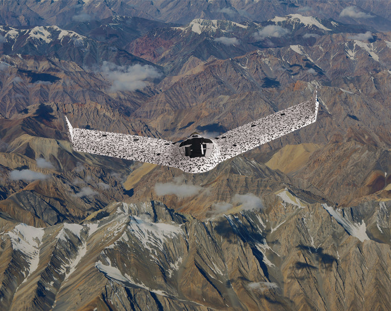
eBee TAC is a Blue UAS–registered fixed-wing drone engineered for secure, high-precision mapping in tactical and governmental operations. Designed for field agility, it deploys in just 3 minutes by a single operator, covering up to 500 hectares (1,235 acres) in one flight with an optional RTK/PPK module that achieves 1.5 cm (0.6 in) absolute accuracy.
Built from Curv® polypropylene composite, its rugged shell absorbs belly landings in harsh terrain, while encrypted SD storage, AES-256 radio link, and NDAA-compliant architecture safeguard operational integrity. The drone supports RGB, thermal, and 3D camera payloads, integrates with MGRS-enabled eMotion software, and offers full compatibility with CivTAK, ATAK, and Google Earth Enterprise platforms.
Ideal for disconnected environments, BVLOS operations, and missions near people, eBee TAC is trusted globally by defense agencies—including the U.S. Army Corps of Engineers and French Navy—as a proven, reliable tool for mapping critical areas safely and efficiently.
Key Features
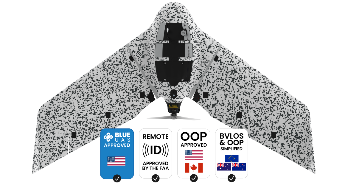
- Blue UAS Registered: Cleared for U.S. Department of Defense procurement; bypasses waiver requirements
-
Mapping Performance:
- Up to 500 ha / 1,235 ac per flight at 120 m altitude
- 90-minute endurance with smart Li-polymer batteries
- Optional RTK/PPK: 1.5 cm (0.6 in) absolute accuracy without GCPs
- Camera Compatibility: Supports RGB, 3D (patented), and thermal payloads for day/night operations
- Deployment: 3 minutes (PPK); 10 minutes (RTK); single operator–ready
- Software: eMotion with MGRS coordinates, offline planning, live path edits, multi-drone control
-
Security Architecture:
- AES-256 encrypted radio link
- Encrypted SD card data
- Silent radio modes + log file suppression
-
Durability:
- Lightweight at 1.6 kg (3.5 lbs)
- Shock-absorbent Curv® composite shell
- IP67-certified hard transport case included
-
Regulatory & Safety Compliance:
- NDAA-compliant hardware/software
- FAA Remote ID approved
- OOP & BVLOS certified in U.S., Canada, and Brazil
- M2 Mitigation Design Verification by EASA
- Post-Processing Ready: Integrates with PIX4D, Esri Drone2Map, Agisoft, ArcGIS, and Hexagon platforms
- Accessories: Backpack, encrypted SDs, charger/discharger, USB modem, spare props, radio tracker, GeoBase GNSS module
| Metric | eBee TAC | Quadcopter (Tactical) | Terrestrial Toolkit |
|---|---|---|---|
| Coverage/Flight | 500 ha / 1,235 ac | 40 ha / 99 ac | 8 ha / 19 ac |
| Accuracy (RTK) | 1.5 cm / 0.6 in | 3.5–4 cm | 1–3 cm |
| Flight Time | 90 minutes | 30–45 minutes | Not applicable |
| Deployment Time | 3–10 minutes | 10–15 minutes | 30+ minutes |
| Operator Requirement | 1 | 2+ | 2–3 |
| Safety Rating | OOP + BVLOS approved | Limited | Ground risk only |
Detailed Specifications
| Specification | Details |
|---|---|
| Weight | 1.6 kg (3.5 lbs) |
| Flight Time | Up to 90 minutes |
| Mapping Accuracy | 1.5 cm / 0.6 in (RTK/PPK) |
| Coverage/Flight | Up to 500 ha / 1,235 ac |
| Flight Range | 55 km / 34 mi |
| Deployment Time | 3 min (PPK), 10 min (RTK) |
| Camera Payloads | RGB, Thermal, 3D interchangeable modules |
| Underbody Material | Curv® Polypropylene composite |
| Transport Case | IP67 military-grade with STANAG certification |
| Security Features | AES-256 radio, encrypted SD, radio silence mode |
| Software | eMotion with MGRS, multi-UAV, offline terrain planning |
| Compliance | NDAA, Blue UAS, FAA Remote ID, BVLOS, OOP (U.S./Canada) |
| Deployment Roles | Disaster assessment, perimeter security, tactical planning, reconnaissance |
| Compatible Platforms | CivTAK, ATAK, GEEP, Google Earth Enterprise |
| Post-Processing | PIX4D, Drone2Map, Agisoft Metashape, ArcGIS, Hexagon |
Manuals & Documents
General Warranty Info:
- Ripping It Outdoors works closely with our manufacturers to supply and support your products warranty needs as best as possible!
- The majority of products come with a manufacturer represented warranty against manufacturing defects for at least a 12 month period after the date of sale.
- Expendable components and "wear parts" including but not limited to blades, knives, teeth, oil, chain sprockets, skid shoes, knife mounting discs, and similar components are usually excluded from manufacturer warranties.
- Please reach out to us for any specific warranty information needed about products and parts you can’t find!
Videos
Shipping
$1 Shipping Quote Info:
- Contact Us For Shipping Quotes. All $1 products are listed as quote only because we can not display their pricing online.
- Low shipping rates for customers. We have negotiated the best possible rates for customers from our trusted carriers (ODFL, ESTES, UPS, and FedEx) & Top Private Drivers
- Negotiate shipping rates if you think we can do better please reach out. Keep in mind some shipping rates also include assembly & configuration as well!
- Complimentary lift gate service on all freight shipments where it’s possible. We guarantee safe delivery!