


AeroVironment | Quantix Mapper Drone | 1m Wingspan | 45-Min Flight Time | 8” Screen Size | Coverage 400 Acres | For Precision Agriculture & Environmental Monitoring
AeroVironment | Quantix Mapper Drone | 1m Wingspan | 45-Min Flight Time | 8” Screen Size | Coverage 400 Acres | For Precision Agriculture & Environmental Monitoring
Couldn't load pickup availability
Couldn't load pickup availability


Product Description
AeroVironment | Quantix Mapper Drone | 1m Wingspan | 45-Min Flight Time | 8” Screen Size | Coverage 400 Acres | For Precision Agriculture & Environmental Monitoring
DESCRIPTION
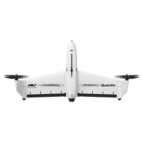
Unlock the full potential of your field assessments and environmental monitoring with the AeroVironment Quantix Mapper Drone a groundbreaking UAV designed to simplify aerial mapping for farmers, agronomists, environmental scientists, and land managers. Whether you’re a seasoned drone pilot or a first-time flyer, the Quantix Mapper offers a uniquely intuitive experience, combining the vertical takeoff and landing (VTOL) versatility of a multirotor with the efficiency and range of a fixed-wing aircraft.
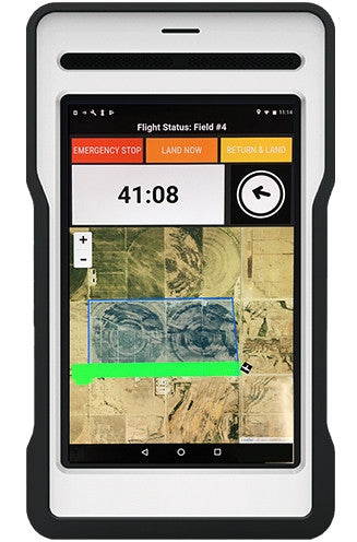
Imagine surveying up to 400 acres in just 45 minutes with crisp, high-resolution imagery delivered straight to the included 8-inch tablet no additional devices, internet, or complicated software needed. The drone’s hybrid design ensures stable, safe takeoff and landing while maximizing aerodynamic efficiency for extensive coverage.
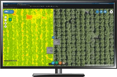
With dual 18MP RGB and multispectral cameras, you’ll instantly receive actionable insights into crop health, storm damage, or environmental changes all within your field, right when you need them. The Quantix Mapper empowers you to detect water stress, pest infestations, weed growth, and disease before they threaten your yield, making it the ultimate tool for precision agriculture and rapid environmental response.
Durable, lightweight, and engineered with carbon fiber reinforcement, this drone is built for the rigors of on-farm and fieldwork conditions. From crop scouting and growth monitoring to flood mapping and disaster assessment, the Quantix Mapper makes complex aerial imaging simple, fast, and accurate.
Key Features
- Fully automated VTOL drone combines vertical takeoff and landing with fixed-wing efficiency, allowing for quick, safe launches and smooth transitions for extended flight range.
- Covers up to 400 acres in a single 45-minute flight, ideal for large-scale crop scouting and environmental monitoring.
- Equipped with dual built-in 18MP cameras capturing high-resolution RGB images at 1" per pixel and multispectral NDVI images at 2" per pixel, enabling precise crop health analysis.
- Integrated 8” ground control tablet with preloaded mapping software offers immediate access to georeferenced Quick-Look™ maps no internet or additional software required.
- Lightweight carbon fiber reinforced airframe with a 1-meter wingspan ensures durability and reliable performance in various field conditions.
- Compatible with tractors requiring 400–500 horsepower, making it a perfect aerial companion for modern farming operations.
- Instantly available RGB and NDVI images allow users to detect water stress, weed infestations, and disease pressure on-site, improving decision-making speed.
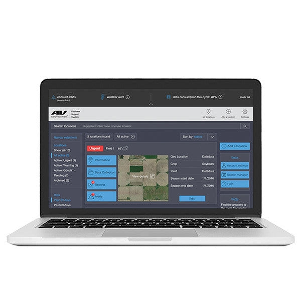
- Advanced GIS technology and AV DSS integration enable detailed mapping and analytics, helping users monitor crop growth during critical stages and respond to storm, flood, or fire damage quickly.
- Self-calibrating solar sensor balances ambient light conditions, ensuring consistent image quality in varying sunlight environments.
- Capable of operating in temperatures ranging from 0°F to 120°F, suitable for diverse climates and seasons.
- Secure 900 MHz encrypted communication and WiFi connectivity provide reliable data transmission and drone control.
- Flight speed of up to 45 mph covers fields quickly, reducing time spent on aerial surveying and increasing productivity.
- On-board SD card storage keeps all imagery secure and easily transferable for further analysis or reporting.
- Safe to operate in winds up to 20 mph, maintaining stability and image quality under typical field conditions.
- Ideal for precision agriculture professionals, environmental scientists, and land managers seeking fast, accurate, and user-friendly aerial mapping without extensive drone piloting experience.
Detailed Specifications
| Specification | Details |
|---|---|
| Model | AeroVironment Quantix Mapper Drone |
| Flight Mode | Hybrid VTOL (Vertical Takeoff and Landing + Fixed-Wing Flight) |
| Flight Time | Up to 45 minutes |
| Maximum Coverage | Up to 400 acres per flight at 360 ft AGL |
| Maximum Altitude | 7,500 ft (2,286 meters) |
| Flight Speed | 45 mph (20 m/s) |
| Weight | 5 lbs (2.27 kg) |
| Wingspan / Dimensions | 1 meter (3.2 feet) wingspan |
| Camera System | Dual 18 MP cameras (RGB & Multispectral) |
| RGB Image Resolution | 1 inch per pixel at 360 ft altitude |
| Multispectral Image Resolution | 2 inches per pixel at 360 ft altitude |
| Image Size | RGB: 4864 x 3648 pixels; Multispectral: 2432 x 1824 pixels |
| Field of View (FOV) | 59.2° x 46° |
| Camera Sensor Size | 6.08 mm width x 4.56 mm height |
| Focal Length | 5.4 mm |
| Optical Format | 1/2.3 inch |
| Image Formats | GeoTIFF, JPG (RGB); JPG with Lat/Long (Multispectral) |
| Data Storage | On-board SD card |
| Communication | 900 MHz encrypted radio & Wi-Fi |
| Operating Temperature | 0°F to 120°F (-18°C to 49°C) |
| Wind Limits | Up to 20 mph (9 m/s) |
| Self-Calibrating Sensor | Built-in solar sensor for ambient light and color balance |
| Tablet Display | 8-inch touchscreen, preloaded with mapping software |
| Use Cases | Precision agriculture, crop scouting, environmental monitoring, storm/flood/fire damage assessment, flood mapping, elevation modeling |
| Included in Package | Quantix Mapper UAV, 8” Operating Tablet, Battery & Charger, User Guide |
Manuals & Documents
Product Brochure
General Warranty Info:
- Ripping It Outdoors works closely with our manufacturers to supply and support your products warranty needs as best as possible!
- The majority of products come with a manufacturer represented warranty against manufacturing defects for at least a 12 month period after the date of sale.
- Expendable components and "wear parts" including but not limited to blades, knives, teeth, oil, chain sprockets, skid shoes, knife mounting discs, and similar components are usually excluded from manufacturer warranties.
- Please reach out to us for any specific warranty information needed about products and parts you can’t find!
Videos
Shipping
General Shipping Info:
- Instantly calculate shipping quotes to the lower 48 states by 1. adding this product to your cart, 2. click continue to the checkout page and 3. enter your shipping address to check rates. Contact us for quotes for shipping to Hawaii, Alaska, Canada, Mexico and Internationally.
- Complimentary lift gate service on all freight shipments where it’s possible. We guarantee safe delivery!
- Low shipping rates for customers. We have negotiated the best possible rates for customers from our trusted carriers (ODFL, ESTES, UPS, and FedEx).
- Negotiate shipping rates if you think we can do better please reach out. Keep in mind some shipping rates also include assembly & configuration as well!