


AgEagle eBee TAC Public Safety Drone | 90-Min Flight | 1.5 cm Accuracy | Coverage 1,235 Acre per flight
AgEagle eBee TAC Public Safety Drone | 90-Min Flight | 1.5 cm Accuracy | Coverage 1,235 Acre per flight
Couldn't load pickup availability
Couldn't load pickup availability


How To Get A Quote
***Online pricing not available, Please request a quote:***
How To Get A Quote:
Option 1:
“Contact Us to make sure you are getting the best unit possible. These machines are complex so let us help you get exactly what you need!
Option 2: (quickest response times)
Step 1. Add the item to your cart
Step 2. Checkout or Click on the Chat button box that is at the bottom right of your screen
Step 3. Please tell us any info you think we would need to know
Step 4. Relax, our team is processing your request and an expert will be in touch to get you exactly what you need!
Product Description
AgEagle eBee TAC Public Safety Drone | 90-Min Flight | 1.5 cm Accuracy | Coverage 1,235 Acre per flight
DESCRIPTION
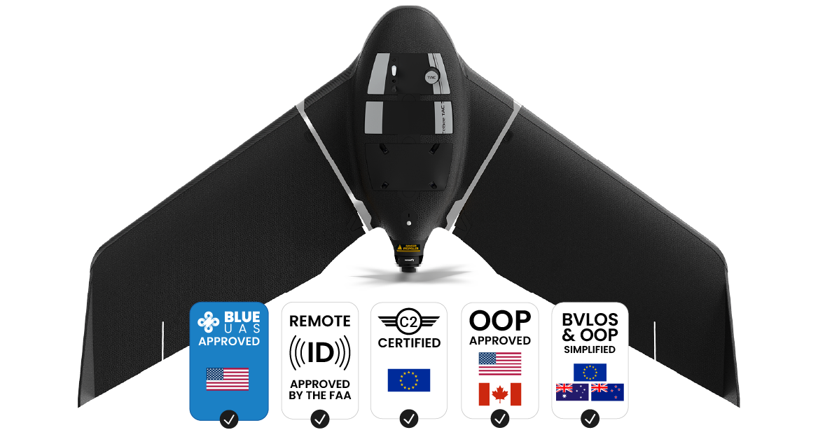
The eBee TAC Public Safety Drone is a rugged, NDAA-compliant fixed-wing UAV engineered for first responders, defense agencies, and tactical survey teams. Capable of mapping up to 500 hectares (1,235 acres) in a single 90-minute flight, it delivers actionable 2D, 3D, RGB, and thermal imagery—even in harsh and disconnected environments.
Weighing just 1.6 kg (3.5 lbs), the drone is safe for Operations Over People (OOP) in both the U.S. and Canada, while its Swiss-assembled construction meets stringent reliability standards. With optional RTK/PPK activation, the drone achieves up to 1.5 cm / 0.6 in accuracy, making it a precision tool for time-sensitive missions like disaster assessment, perimeter monitoring, and tactical planning.
Fully compatible with CivTAK, eMotion flight management software, and post-processing suites such as PIX4D, Esri Drone2Map, and Agisoft, eBee TAC streamlines aerial data collection for command centers, field teams, and infrastructure managers.
Key Features
- Mission Reach: Maps up to 500 ha / 1,235 ac with a flight range of 55 km / 34 mi
- Flight Time: Up to 90 minutes for extended aerial operations
- Mapping Accuracy: Achieves 1.5 cm / 0.6 in with RTK/PPK, even without GCPs
- Weight Class: Lightweight 1.6 kg / 3.5 lbs for global regulatory flexibility
- Camera Options: Compatible with 3D, RGB, multispectral, and thermal payloads
-
Data Security:
- AES-256 encrypted radio link
- Encrypted SD card storage
- NDAA-compliant (no blacklisted components)
-
Safety Certifications:
- FAA Remote ID approved
- OOP certified in U.S. & Canada
- EU C2 class for close-proximity flight
-
Operational Tools:
- One-person deployment
- 3-minute setup (standalone); 10-minute with RTK
- Offline flight planning, corridor mapping, POI surveys
- Ping USB for real-time air traffic awareness
-
Ground Software:
- eMotion for flight planning, 3D simulation, live mission edits
- Supports multi-drone operations (up to 4 units simultaneously)
- Durability: Shock-absorbent Curv® polypropylene shell endures belly landings in rough terrain
-
Extensions & Accessories:
- Drone backpack (rainproof, 10 kg loaded)
- RTK / PPK kit
- Radio tracker
- GeoBase Septentrio GNSS module
- Spare parts & maintenance kit
- Manual control option
| Platform | Max Mapping Area | Accuracy (RTK) | Deployment Time | Operator |
|---|---|---|---|---|
| eBee TAC Public Safety | 500 ha / 1,235 ac | 1.5 cm / 0.6 in | 3 min (standalone) 10 min (RTK) |
1 person |
| Quadcopter Drone | 40 ha / 99 ac | 3.6 cm / 1.4 in | 10–15 min | 2–3 people |
| Terrestrial Survey Tools | 8 ha / 19 ac | 1–3 cm | Up to 1 hour | 1–2 people |
Detailed Specifications
| Specification | Details |
|---|---|
| Mapping Area | Up to 500 ha / 1,235 ac per flight |
| Flight Time | Up to 90 minutes |
| Flight Range | 55 km / 34 mi |
| Takeoff Weight | 1.6 kg / 3.5 lbs |
| Accuracy | 1.5 cm / 0.6 in with RTK/PPK (no GCPs) |
| Deployment Time | 3 minutes standalone; 10 minutes with RTK |
| Construction Material | Curv® polypropylene composite (shock absorbent) |
| Software | eMotion flight planning and control suite |
| Regulatory Certifications | FAA Remote ID, U.S./Canada OOP, EU C2 class |
| Cybersecurity | AES-256 radio encryption, NDAA-compliant build |
| Accessories Included | Drone backpack, Radio tracker, RTK/PPK module |
| Compatible Cameras | RGB, Multispectral, Thermal, 3D Photogrammetry |
| Post-Processing Software | PIX4D, Esri Drone2Map, Agisoft, ArcGIS, Trimble, etc. |
| Operating Altitude | Typically 120 m / 400 ft AGL |
Manuals & Documents
General Warranty Info:
- Ripping It Outdoors works closely with our manufacturers to supply and support your products warranty needs as best as possible!
- The majority of products come with a manufacturer represented warranty against manufacturing defects for at least a 12 month period after the date of sale.
- Expendable components and "wear parts" including but not limited to blades, knives, teeth, oil, chain sprockets, skid shoes, knife mounting discs, and similar components are usually excluded from manufacturer warranties.
- Please reach out to us for any specific warranty information needed about products and parts you can’t find!
Videos
Shipping
$1 Shipping Quote Info:
- Contact Us For Shipping Quotes. All $1 products are listed as quote only because we can not display their pricing online.
- Low shipping rates for customers. We have negotiated the best possible rates for customers from our trusted carriers (ODFL, ESTES, UPS, and FedEx) & Top Private Drivers
- Negotiate shipping rates if you think we can do better please reach out. Keep in mind some shipping rates also include assembly & configuration as well!
- Complimentary lift gate service on all freight shipments where it’s possible. We guarantee safe delivery