


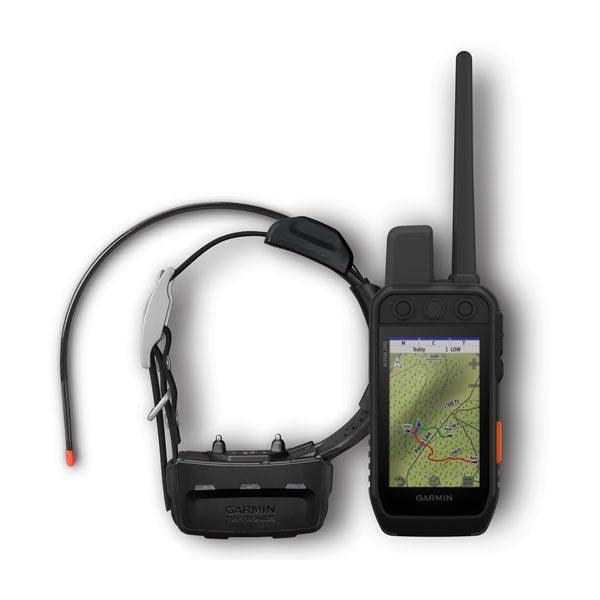

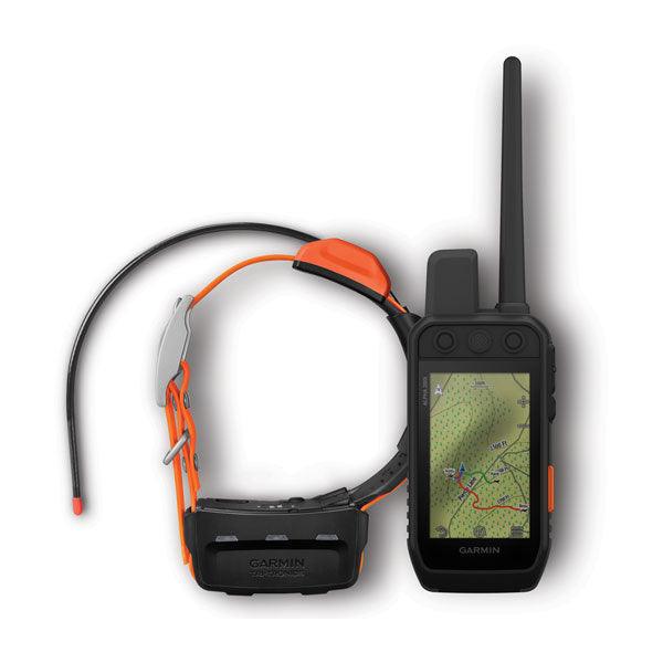
Garmin Alpha 200i Handheld With Alpha® T Series Dog Tracking Collar
Garmin Alpha 200i Handheld With Alpha® T Series Dog Tracking Collar
Couldn't load pickup availability
Couldn't load pickup availability


Product Description
Garmin Alpha 200i Handheld Garmin
DESCRIPTION
STRONG CONNECTION. STRONG BOND.
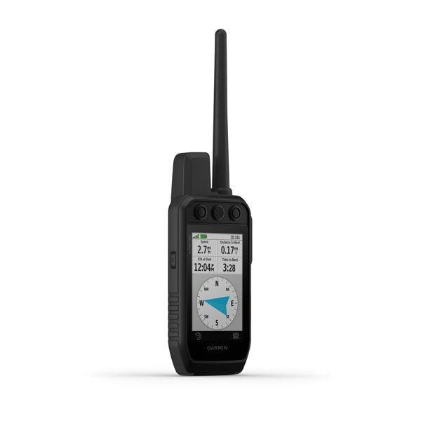
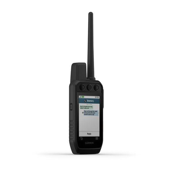
Track and train your dogs with the Alpha 200i system, featuring inReach technology, a sunlight-readable 3.5” capacitive touchscreen, and a user-friendly, six-button design.
The Garmin Alpha® 200i Handheld is the ultimate tool for tracking and training dogs in the field. With inReach® satellite technology, a 3.5” sunlight-readable touchscreen, and an easy-to-use six-button design, this device provides precise dog tracking, advanced training options, and essential safety features.
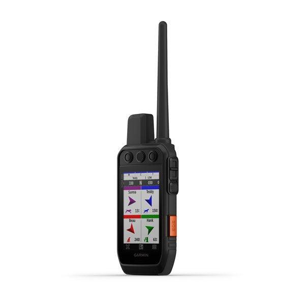
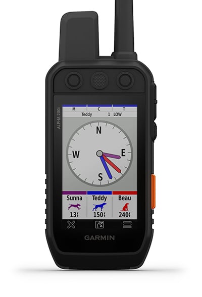
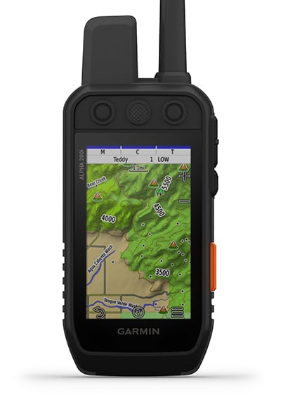
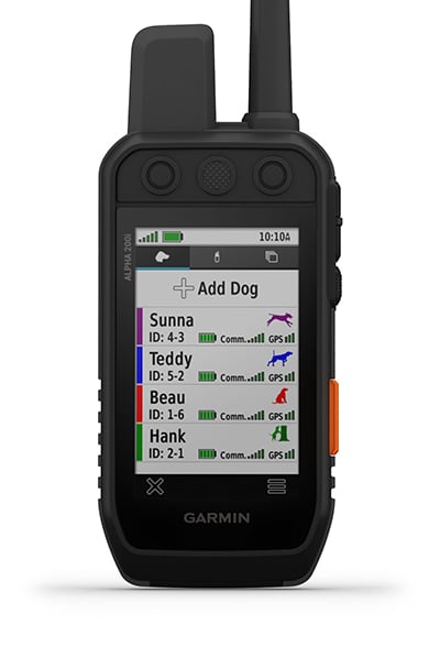
Track up to 20 dogs at once, monitor hunting patterns, and customize training cues with 18 levels of stimulation. The Pro View Compass mode provides at-a-glance tracking, showing distance, direction, and status (Treed or OnPoint).
With multi-GNSS support (GPS & Galileo), barometric altimeter, and tilt-compensated 3-axis compass, the Alpha® 200i ensures highly accurate tracking and navigation. It also includes preloaded TopoActive maps, public land boundaries, and optional HuntView Plus maps (sold separately) for superior outdoor exploration.
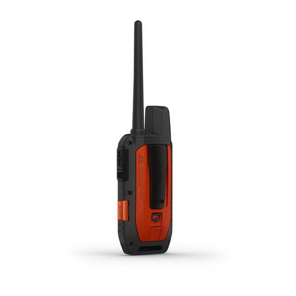
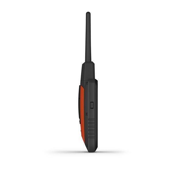
Designed for rugged outdoor use, it features a replaceable battery (up to 20 hours per charge), Wi-Fi/Bluetooth/ANT+ connectivity, and optional BirdsEye Satellite Imagery downloads.
Key Features
Dog Tracking & Training
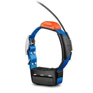
- Track Up to 20 Dogs: Monitor dogs up to 9 miles away with 2.5-second updates (TT™ 15/T 5 tracking collars required).
- Pro View Compass Mode: Provides real-time tracking of direction, distance, and dog status.
- Hunt Metrics: Monitor dog movement, speed, and hunting efficiency to track performance.
- 18 Training Stimulation Levels: Customizable momentary & continuous stimulation options.
Mapping & Navigation
- Multi-GNSS Support: Uses GPS & Galileo for superior tracking accuracy.
- Preloaded TopoActive Maps: Terrain contours, public land boundaries, rivers, and elevation data for easy navigation.
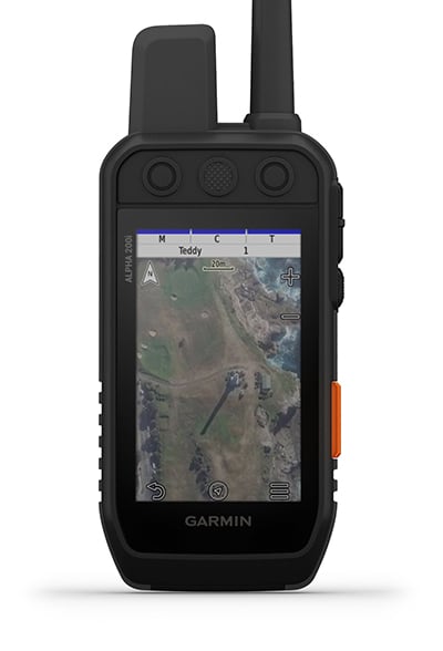
- BirdsEye Satellite Imagery: Direct-to-device downloads for detailed aerial views (subscription required).
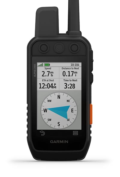
- Navigation Sensors: Barometric altimeter for elevation tracking and a 3-axis electronic compass for accurate bearings.
User-Friendly Design
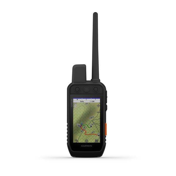
- Sunlight-Readable 3.5” Touchscreen: Glove-friendly for outdoor convenience.
- Six-Button Layout: Quickly toggle between tracking, training, and navigation settings.
- Long Battery Life: Up to 20 hours (15 hours with inReach enabled).
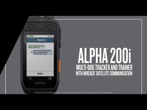
inReach® Safety & Connectivity
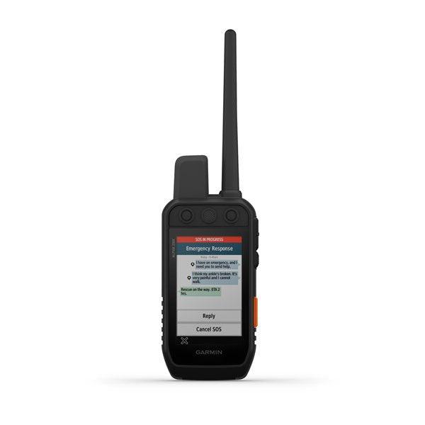
- Two-Way Messaging: Send & receive SMS and email via Iridium® satellite network (subscription required).
- SOS Emergency Alerting: Trigger an interactive SOS to the Garmin IERCC 24/7 emergency response center.
- Live Location Sharing: Let family & friends track your movement with LiveTrack.
Durability & Expandability
- Rugged & Waterproof: IPX7-rated, shockproof, and built for tough outdoor conditions.
- Expandable Memory: microSD™ card slot supports additional maps & data storage.
Take dog tracking and training to the next level.

TRACK YOUR PACK:

Monitor up to 20 dogs from up to 9 miles (depending on dog device) with a 2.5-second update rate.
DOG LIST/GROUP MANAGEMENT:

Keep inactive dogs in your dog list, and manage active groups so you don’t have to add and remove dogs for every hunt.
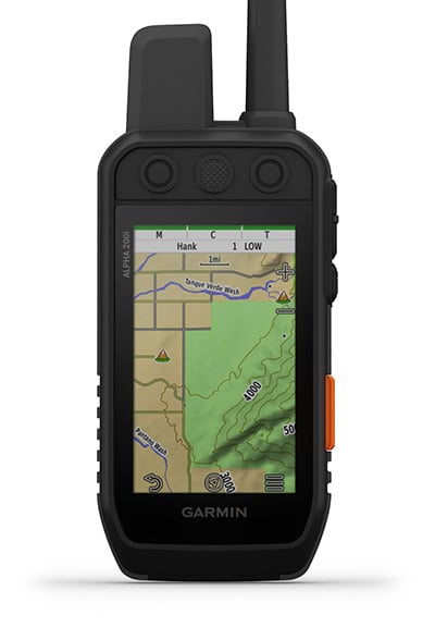
PUBLIC LAND BOUNDARIES:

Optional display of public land boundaries on topographical maps helps you know that you’re venturing where you’re supposed to be.
HUNT METRICS:

See each dog’s daily hunting patterns, distance, and speed so you can monitor performance and help prevent overheating. Pair with TT™ 15 tracking and training collars.
SIX-BUTTON DESIGN:

Use dedicated buttons for fast training cues and minor adjustments in the field.
18 LEVELS OF STIMULATION:

Momentary and continuous stimulation options let you customize training for each dog.
GARMIN EXPLORE™ APP:

Pair with the Garmin Explore app on your compatible smartphone to see real-time dog tracking information, save collections of dog tracks, and replay tracks to see exactly what happened during your hunt.
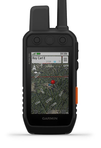
PRO VIEW COMPASS:

The pro view compass mode gives you simple, at-a-glance tracking that shows which direction and how far away your dogs are, plus you will see when a dog is “Treed” or “OnPoint.”
NAVIGATION SENSORS:

A barometric altimeter helps you accurately monitor ascent and descent and see short-term trends in air pressure, and the built-in tilt-compensated three-axis electronic compass keeps your bearing — whether you’re moving or not.
Navigate your surroundings.

MULTI-GNSS SUPPORT:
TOPOACTIVE MAPS:
BIRDSEYE SATELLITE IMAGERY:
NAVIGATION SENSORS:
SEE IT ALL:
STAY ON THE MOVE:
ADDITIONAL MAPPING:
Stay in touch using inReach technology.

Detailed Specifications
| Feature | Specification |
|---|---|
| Brand Name | Garmin Alpha® 200i |
| Dimensions | 2.7” x 6.4” x 1.3” (without antenna) |
| Weight | 9.9 oz (280g) (includes standard antenna & battery) |
| Display Size | 3.5” diagonal (88.9mm) |
| Display Resolution | 282 x 470 pixels |
| Display Type | Transflective color TFT touchscreen |
| Battery Type | Rechargeable lithium-ion (included) |
| Battery Life | Up to 20 hours (15 hours with inReach enabled) |
| Water Rating | IPX7 (waterproof) |
| Memory Storage | 16GB (expandable via microSD™) |
| GNSS Support | GPS & Galileo |
| Waypoints | 10,000 |
| Routes | 250 |
| Track Log | 20,000 points, 250 saved GPX tracks, 300 saved FIT activities |
| Dog Tracking Capacity | Up to 20 dogs (with TT™ 15/T 5 collars) |
| Wireless Connectivity | Wi-Fi, Bluetooth, ANT+ |
| Mapping & Navigation | Preloaded TopoActive maps, BirdsEye Satellite Imagery, HuntView Plus (sold separately) |
In Package
- Alpha 200i handheld with rechargeable lithium-ion battery pack
- Belt clip
- AC adapter
- micro USB cable
- Documentation
Package Included:
- Alpha® 200i handheld with rechargeable lithium-ion battery pack
- Belt clip
- AC adapter
- microUSB cable
- Documentation
Manuals & Documents
General Warranty Info:
- Ripping It Outdoors works closely with our manufacturers to supply and support your products warranty needs as best as possible!
- The majority of products come with a manufacturer represented warranty against manufacturing defects for at least a 12 month period after the date of sale.
- Expendable components and "wear parts" including but not limited to blades, knives, teeth, oil, chain sprockets, skid shoes, knife mounting discs, and similar components are usually excluded from manufacturer warranties.
- Please reach out to us for any specific warranty information needed about products and parts you can’t find!
Videos
Shipping
General Shipping Info:
- Instantly calculate shipping quotes to the lower 48 states by 1. adding this product to your cart, 2. click continue to the checkout page and 3. enter your shipping address to check rates. Contact us for quotes for shipping to Hawaii, Alaska, Canada, Mexico and Internationally.
- Complimentary lift gate service on all freight shipments where it’s possible. We guarantee safe delivery!
- Low shipping rates for customers. We have negotiated the best possible rates for customers from our trusted carriers (ODFL, ESTES, UPS, and FedEx).
- Negotiate shipping rates if you think we can do better please reach out. Keep in mind some shipping rates also include assembly & configuration that as well!