


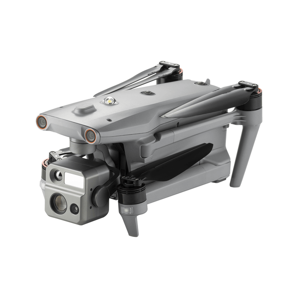
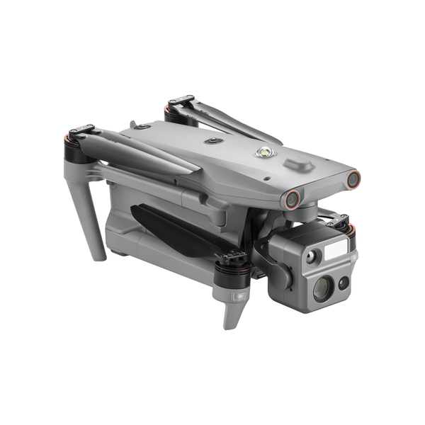
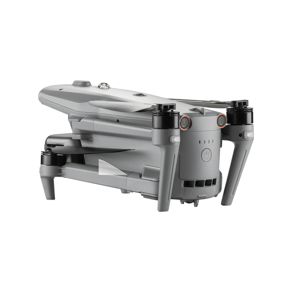
Autel Robotics EVO Max 4N Intelligent Drone
Autel Robotics EVO Max 4N Intelligent Drone
Couldn't load pickup availability
Couldn't load pickup availability


Product Description
Autel Robotics EVO Max 4N Intelligent Drone
DESCRIPTION
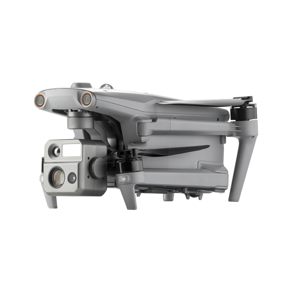
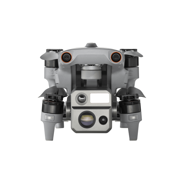
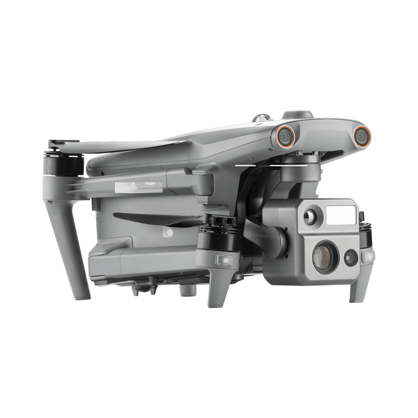
The Autel EVO Max 4N is the next generation of intelligent, agile drones, equipped with 720-degree obstacle avoidance and A-Mesh 1.0 networking support. This commercial drone is designed for night operations, featuring starlight night vision, zoom, thermal cameras, and full laser ranging capabilities. The EVO Max 4N's exceptional starlight camera allows it to operate in lighting conditions as low as 0.0001 Lux, delivering unparalleled performance in the dark. This makes it ideal for night surveys, emergency responses, and other critical missions that require superior visibility. With its advanced features and capabilities, the Autel EVO Max 4N is the ultimate night-ops-ready drone for commercial applications
What's in the Box:
- Aircraft (includes battery, propeller, gimbal, gimbal cover, and 64GB SD card) — 1 unit
- Smart Controller V3 (control sticks included) — 1 unit
- Spare Propeller (pair) — 1 set
- Battery Charger — 1 unit
- RC Charger — 1 unit
- Data Cable — 1 unit
- RC Charging Cable — 1 unit
- Smart Controller Lanyard — 1 unit
- Smart Controller Cover — 1 unit
- Smart Controller Spare Joysticks (pair) — 1 set
- Rugged Case — 1 unit
- EVO Max 4T User Manual — 1 booklet
Key Features
Autonomous Path Finding
The Autel EVO Max 4N is powered by Autel's advanced Autonomy Engine, which collects surrounding environmental data and plans 3D flight paths through complex environments like mountains, forests, and buildings. This drone is ideal for a wide range of commercial applications, including rapid 3D scene reconstruction, public safety overwatch, industrial inspection, and land surveying.

Navigation in GPS Denied Environment
Advanced sensors allow the EVO Max 4N to navigate within hardened structures, underground, or in environments without GPS.

Accurate Object Identification and Tracking
The EVO Max 4N uses Autel's AI recognition technology to automatically identify and lock onto different types of targets such as heat sources, moving people, or vehicles. This enables the drone to achieve high-altitude tracking and data collection for law enforcement and other applications where reliable, real-time surveillance is crucial.

No Blind Spots
Ultimate Obstacle Avoidance
The EVO Max 4N is a unique commercial drone that combines traditional binocular vision systems with millimeter wave radar technology. This innovative combination enables the onboard Autel Autonomy Engine to detect objects as small as 0.5 inch, removing blind spots and allowing for operation in low light or rainy conditions
Anti Jam, Anti Interference
The EVO Max 4N is equipped with advanced flight control modules and algorithms that are specifically designed to counter RFI, EMI, and GPS spoofing. This feature allows the drone to fly confidently near power lines, critical structures, and in complex areas, making it an ideal tool for industrial inspections, emergency response, and other critical operations.
 Weather Rating-IP43
The EVO Max 4N has an IP43 Ingress Protection rating, which means that it is protected against solid objects greater than 1mm in diameter and against sprays of water up to 60 degrees from the vertical. This makes the drone more durable and able to withstand challenging weather conditions, making it ideal for use in a wide range of applications.
Operation Temperature
-4 ℉ to 122 ℉
Platform Capability:
EVO Max 4N redefines portability with its powerful platform and all weather design.
- 42 mins Max. Flight Time
- 23,000 ft Service Ceiling
- 12.4 miles Image Transmission Rang
- 27 mph Max. Wind Resistance

Hot-Swappable Battery:
The Autel EVO Max 4N features a hot-swappable battery system, allowing for extended flight times without any downtime. This innovative system enables users to easily swap out batteries while the drone is still in operation, thereby ensuring that there is no interruption to operations and making it ideal for use in time-critical applications where every second counts.
- 8070 mAh& Capacity
- 14.88VVoltage
- LiPo 4SBattery Type
- 120whEnergy
- 520gNet Weight
- SupportHot Swap

Autel Autonomy:
EVO Max 4N is the only commercial drone that combines traditional binocular vision systems with millimeter wave radar technology, which enables the onboard Autel Autonomy Engine to detect objects as small as 0.5 inch, effectively eliminating blind spots and allowing operation in low light or rainy conditions.

- Binocular Vision System

- Millimeter Wave Rada
A-Mesh 1.0
The Drone Industry's First Mesh Networking Technology
EVO Max 4N features the new A-Mesh system, enabling drone-to-drone autonomous communication, connection, and collaboration.
Strong Anti-Interference
The EVO Max 4N can communicate seamlessly with other drones in the vicinity, unlike a traditional chain structure. If a single drone fails or exits unexpectedly, the entire system will independently self-organize and continue to relay critical information.

The A-Mesh system in the EVO Max 4N allows multiple aircraft in the surrounding area to serve as relay points, significantly enhancing the effectiveness of operations beyond visual line of sight (BVLOS).
The EVO Max 4N offers the capability to control multiple drones autonomously, either by a single pilot or by a group of pilots working simultaneously, with or without LTE coverage.

Communication modes can be placed statically on hills or poles to provide full coverage to an area, or a swarm of drones can provide mobile communication points to extend the coverage of the entire group.
Autel SkyLink 3.0
The EVO Max 4N SkyLink 3.0 system comes with 6 antennas, 4 frequency bands, AES-256 encryption*, and optional 4G integration* to provide users with the most advanced flight capabilities ever in an EVO.
-
12.4 miles Image Transmission Distance -
<150ms Latency -
1080p/60fps Real-Time Image Quality -
900MHz/2.4GHz/5.2GHz/5.8GHz** Frequency Bands

This feature will be available in a future update. **5.2GHz is only applicable for FCC, CE, and UKCA regions. 900MHz is only applicable for FCC regions.
Mission Ready Payload
The payload integrates wide-angle camera, zoom camera, thermal camera and a laser rangefinder for all data capture needs and critical decision making.
- As low as 0.0001 Lux
operate in lighting condition - Auto ISO100-ISO450000
- Super Sensitive Mod 50MP
- Wide Camer 1/1.28 CMOS
Wide Camera Senso 640x512 - Thermal Resolutio 5m to 1.2km
Laser Rangefinder Measuring Range

Chase the Heat and Explore the Night
Autel Enterprise App Platform
The Autel Enterprise App has been specifically designed for industrial applications, with a brand-new interface that streamlines operation and enhances usability. With additional features and semi-autonomous modes, the app maximizes the EVO Max 4N's mission capability, enabling efficient and effective operation in a wide range of scenarios.

Smart Features

3D Map Planning
Plan, create, and execute 3D waypoint mission plan on a 3D map.

-
Quick Mission Temporary quick missions can be created while executing other missions, and multiple sub-missions can be stacked for enhanced flexibility.

Mission Reproduction
With this feature activated, fly a manual or semi-autonomous mission, or string multiple missions together. The EVO Max4N will automatically record the camera angles and replicate the mission you just flew.
Multiple Mission Types
The Autel Enterprise App offers a range of autonomous and semi-autonomous mission planning capabilities for a variety of applications, including public safety, inspection, and surveying.

- Spiral Mission
Supports helical flight search in a designated area for SAR.

-
Vertical Scan Perform vertical surveys for building facades, open pit walls, and towers

-
Corridor Mission Supports intuitive and effective corridor mission planning for roads, rivers, pipelines, power lines and other narrow,large-scale terrain.

-
Polygon Mission Supports one-click automatic generation of polygon flight areas.

Terrain Follow
Maintain relatively constant altitude from the ground for uneven or sloped terrain

Rectangular Mission
Supports one-click automatic generation of a rectangular flight area.
Data Security
Privacy Protection: Data involving user and aircraft information, including flight logs, locations, and account information can only be physically accessed via the aircraft locally.
Encrypted Data Storage: Supports AES-256 encryption for photos, videos, and flight logs, are password-protected.

Enhanced Live-View

AR Scene
-
-
- Complete Remote Operations System

Used with the EVO Nest, the EVO Max series supports all-weather auto piloting for scenarios such as substations, industrial parks, and rooftops.
- Autel SDK
The Autel SDK is open to the world, helping developers and partners reduce software and hardware development costs and jointly create a new industry ecosystem.


Mobile SDK
Open UX SDK (iOS/Android) can directly call up the ready-made interactive interface.
Accessories

-
Autel Smart Controller V3 Daylight Readable Display: 7.9 inches, 2000nit maximum brightness, 2048*1536 resolution. SuperDownload: Download footage from drone to mobile device at a maximum rate of 20MB/s. Functional Interface: HDMI ports allow connection to 3rd party displays or monitors. Ultra-Long Battery Life: Up to 4.5 hours of continuous operation. 2-hr fast charging from empty. Local Storage: Built-in 128G storage space allows 3rd party apps and mission media storage.

EVO Nest (optional)
EVO Nest is a base for automatic take off, landing, charging, and mission planning for the EVO series. The Nest is designed for all-weather operation and uses a single-piece protective drum with fewer moving parts to simplify maintenance.

RTK Module (optional)
Provides centimeter-accurate positioning data for mapping and reduces electromagnetic interference for flying near critical structures.
Detailed Specifications
| Feature | Details |
|---|---|
| Flight Time | Up to 42 minutes |
| Service Ceiling | 23,000 ft |
| Transmission Range | 12.4 miles |
| Wind Resistance | 27 mph |
| Operating Temperature | -4°F to 122°F |
| IP Rating | IP43 |
| Battery Capacity | 8070 mAh, hot-swappable |
| Payload | Wide-angle, zoom, thermal cameras, laser rangefinder |
| Camera Specifications | Details |
|---|---|
| Night Vision | Operates at 0.0001 Lux |
| Wide Camera | 50 MP, 1/1.28 CMOS sensor |
| Thermal Resolution | 640 x 512 |
| Laser Range | 5m to 1.2km |
Manuals & Documents
General Warranty Info:
- Ripping It Outdoors works closely with our manufacturers to supply and support your products warranty needs as best as possible!
- The majority of products come with a manufacturer represented warranty against manufacturing defects for at least a 12 month period after the date of sale.
- Expendable components and "wear parts" including but not limited to blades, knives, teeth, oil, chain sprockets, skid shoes, knife mounting discs, and similar components are usually excluded from manufacturer warranties.
- Please reach out to us for any specific warranty information needed about products and parts you can’t find!
Videos
Shipping
$1 Shipping Quote Info:
- Contact Us For Shipping Quotes. All $1 products are listed as quote only because we can not display their pricing online.
- Low shipping rates for customers. We have negotiated the best possible rates for customers from our trusted carriers (ODFL, ESTES, UPS, and FedEx) & Top Private Drivers
- Negotiate shipping rates if you think we can do better please reach out. Keep in mind some shipping rates also include assembly & configuration as well!
- Complimentary lift gate service on all freight shipments where it’s possible. We guarantee safe delivery!