


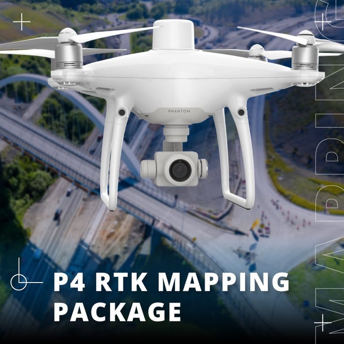

DJI Phantom 4 RTK Mapping Drone | Power Consumption 16 Watt | Up-To 30 Minutes Maximum Flight Time
DJI Phantom 4 RTK Mapping Drone | Power Consumption 16 Watt | Up-To 30 Minutes Maximum Flight Time
Regular price
$5,900.00
Regular price
Sale price
$5,900.00
Unit price
per
Couldn't load pickup availability
Couldn't load pickup availability


Product Description
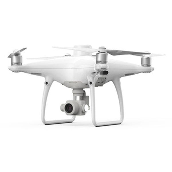
DJI Phantom 4 RTK Mapping Drone | Power Consumption 16 Watt | Up-To 30 Minutes Maximum Flight Time
Description
The DJI Phantom 4 RTK is a premier solution for precision aerial mapping, designed to deliver unprecedented accuracy in a compact form factor. This drone is ideal for professionals across various sectors, providing centimeter-level positioning data that ensures unmatched data precision. With its advanced features and versatile applications, the Phantom 4 RTK is a game-changer in the fields of surveying, agriculture, construction, and emergency response.
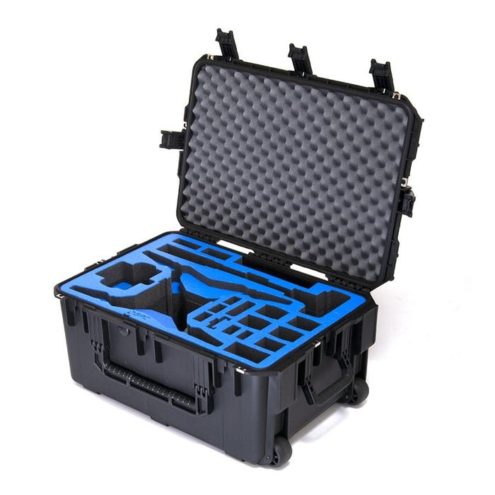
What's in the Box
- 1x DJI Phantom 4 RTK (no Base Station included) # DJI Phantom 4 RTK (S)
Key Features
- Max Flight Time: Up to 30 minutes for extended missions, allowing you to capture more data in a single flight.
- Max Transmission Range: Up to 4.34 miles (7 km) for extensive coverage, ensuring you can monitor large areas without losing connection.
- 20-MP 1" CMOS Sensor: High-resolution imaging for detailed data capture, delivering exceptional image quality for precise analysis.
- Built-in RTK Module: Supports PPK (Post Processed Kinematics) for enhanced data accuracy, ensuring the most precise positioning information.
- Accurate Positioning Data: Features TimeSync for precise data collection, synchronizing the flight controller, camera, and RTK module at the microsecond level to ensure the most accurate measurements.
- Integrated Flight Planning: Compatible with the GS RTK app for efficient mission planning, allowing for automated and streamlined flight operations.
- Complete Mapping Solution: Works seamlessly with DJI Terra for comprehensive mapping capabilities, providing a robust solution for generating detailed and accurate maps.
Detailed Specifications
| Category | Specification |
|---|---|
| Aircraft | |
| Takeoff Weight | 1391 g |
| Diagonal Distance | 350 mm |
| Max Service Ceiling | 19685 ft (6000 m) |
| Max Ascent Speed | 6 m/s (automatic flight); 5 m/s (manual control) |
| Max Descent Speed | 3 m/s |
| Max Speed | 31 mph (50 kph) in P-mode; 36 mph (58 kph) in A-mode |
| Max Flight Time | Approx. 30 minutes |
| Operating Temperature Range | 32° to 104° F (0° to 40℃) |
| Operating Frequency | 2.400 GHz to 2.483 GHz (Europe, Japan, Korea); 5.725 GHz to 5.850 GHz (United States, China) |
| Transmission Power (EIRP) | 2.4 GHz CE (Europe) / MIC (Japan) / KCC (Korea): < 20 dBm; 5.8 GHz SRRC (China) / FCC (USA): < 26 dBm |
| Hover Accuracy Range | RTK enabled: Vertical: ±0.1 m; Horizontal: ±0.1 m; RTK disabled: Vertical: ±0.1 m (vision), ±0.5 m (GNSS) |
| Image Position Offset | Camera center position relative to D-RTK antenna: (36, 0, 192 mm) applied to image coordinates in Exif data |
| Mapping Functions | |
| Mapping Accuracy | Meets ASPRS Accuracy Standards for Digital Orthophotos Class III |
| Ground Sample Distance (GSD) | (H/36.5) cm/pixel (H = altitude in meters) |
| Data Acquisition Efficiency | Max operating area of approx. 1 km² for a single flight at 182 m altitude (GSD approx. 5 cm/pixel) |
| Vision System | |
| Velocity Range | ≤31 mph (50 kph) at 6.6 ft (2 m) above ground with adequate lighting |
| Altitude Range | 0-33 ft (0 - 10 m) |
| Obstacle Sensing Range | 2-98 ft (0.7-30 m) |
| FOV | Forward/Rear: 60° (horizontal), ±27° (vertical); Downward: 70° (front and rear), 50° (left and right) |
| Measuring Frequency | Forward/Rear: 10 Hz; Downward: 20 Hz |
| Operating Environment | Surfaces with clear patterns and adequate lighting (> 15 lux) |
| Camera | |
| Sensor | 1" CMOS; Effective pixels: 20 MP |
| Lens | FOV: 84°; 8.8 mm / 24 mm (35 mm format equivalent: 24 mm); f/2.8 - f/11, autofocus at 1 m - ∞ |
| ISO Range | Video: 100-3200 (Auto), 100-6400 (Manual); Photo: 100-3200 (Auto), 100-12800 (Manual) |
| Mechanical Shutter Speed | 8 - 1/2000 s |
| Electronic Shutter Speed | 8 - 1/8000 s |
| Max Image Size | 4864 × 3648 (4:3); 5472 × 3648 (3:2) |
| Video Recording Modes | H.264, 4K: 3840 × 2160 @ 30p |
| Photo Format | JPEG |
| Video Format | MOV |
| Supported File Systems | FAT32 (≤ 32 GB); exFAT (> 32 GB) |
| Supported SD Cards | MicroSD, Max Capacity: 128 GB; Class 10 or UHS-1 rating required; Write speed ≥ 15 MB/s |
| Operating Temperature Range | 32° to 104° F (0° to 40℃) |
| Intelligent Flight Battery | |
| Capacity | 5870 mAh |
| Voltage | 15.2 V |
| Battery Type | LiPo 4S |
| Energy | 89.2 Wh |
| Net Weight | 468 g |
| Charging Temperature Range | 14° to 104℉ (-10° to 40℃) |
| Max Charging Power | 160 W |
| Intelligent Battery Charging Hub | |
| Input Voltage | 17.3 - 26.2 V |
| Output Voltage and Current | 8.7 V, 6 A; 5 V, 2 A |
| Operating Temperature | 41° to 104℉ (5° to 40℃) |
| GNSS | |
| Single-Frequency GNSS Module | GPS + BeiDou + Galileo (Asia); GPS + GLONASS + Galileo (other regions) |
| Multi-Frequency RTK GNSS | GPS: L1/L2; GLONASS: L1/L2; BeiDou: B1/B2; Galileo: E1/E5a |
| First-Fixed Time | < 50 s |
| Positioning Accuracy | Vertical: 1.5 cm + 1 ppm (RMS); Horizontal: 1 cm + 1 ppm (RMS) |
| Gimbal | |
| Stabilization | 3-axis (tilt, roll, yaw) |
| Pitch | -90° to +30° |
| Max Controllable Angular Speed | 90°/s |
| Angular Vibration Range | ±0.02° |
| Infrared | |
| Obstacle Sensing Range | 0.6-23 ft (0.2 - 7 m) |
| FOV | 70° (Horizontal); ±10° (Vertical) |
| Measuring Frequency | 10 Hz |
| Operating Environment | Surface with diffuse reflection material, reflectivity > 8% (e.g., wall, trees, humans) |
| Remote Controller | |
| Operating Frequency | 2.400 GHz - 2.483 GHz (Europe, Japan, Korea); 5.725 GHz - 5.850 GHz (United States, China) |
| Transmission Power (EIRP) | 2.4 GHz CE / MIC / KCC: < 20 dBm; 5.8 GHz SRRC / FCC: < 26 dBm |
| Max Transmission Distance | FCC: 4.3 mi (7 km); SRRC / CE / MIC / KCC: 3.1 mi (5 km) (Unobstructed, free of interference) |
| Power Consumption | 16 W (typical value) |
| Display | 5.5 inch screen, 1920 × 1080, 1000 cd/m², Android System; Memory 4G RAM + 16G ROM |
| Operating Temperature Range | 32° to 104° F (0° to 40℃) |
| Intelligent Flight Battery Charging Hub | |
| Voltage | 17.5 V |
| Operating Temperature Range | 41° to 104℉ (5° to 40℃) |
| Capacity | 4920 mAh |
| Voltage | 7.6 V |
| Battery Type | LiPo 2S |
| Energy | 37.39 Wh |
| Operating Temperature | -4° to 104℉ (-20° to 40℃) |
| AC Power Adapter | |
| Voltage | 17.4 V |
| Rated Power | 160 W |
Manual & Documents
General Warranty Info:
- Ripping It Outdoors works closely with our manufacturers to supply and support your products warranty needs as best as possible!
- The majority of products come with a manufacturer represented warranty against manufacturing defects for at least a 12 month period after the date of sale.
- Expendable components and "wear parts" including but not limited to blades, knives, teeth, oil, chain sprockets, skid shoes, knife mounting discs, and similar components are usually excluded from manufacturer warranties.
- Please reach out to us for any specific warranty information needed about products and parts you can’t find!
Videos
Shipping
$1 Shipping Quote Info:
- Contact Us For Shipping Quotes. All $1 products are listed as quote only because we can not display their pricing online.
- Low shipping rates for customers. We have negotiated the best possible rates for customers from our trusted carriers (ODFL, ESTES, UPS, and FedEx) & Top Private Drivers
- Negotiate shipping rates if you think we can do better please reach out. Keep in mind some shipping rates also include assembly & configuration as well!
- Complimentary lift gate service on all freight shipments where it’s possible. We guarantee safe delivery!