


Product Description
DJI Terra Mapping Software- Drone Software
DESCRIPTION
Transform Your World with DJI Terra Mapping Software
DJI Terra is an advanced mapping software designed for industry professionals to digitize the physical world. Whether you're working in public safety, construction, infrastructure, agriculture, or filmmaking, DJI Terra offers an intuitive platform to plan, process, and analyze aerial data for impactful results.
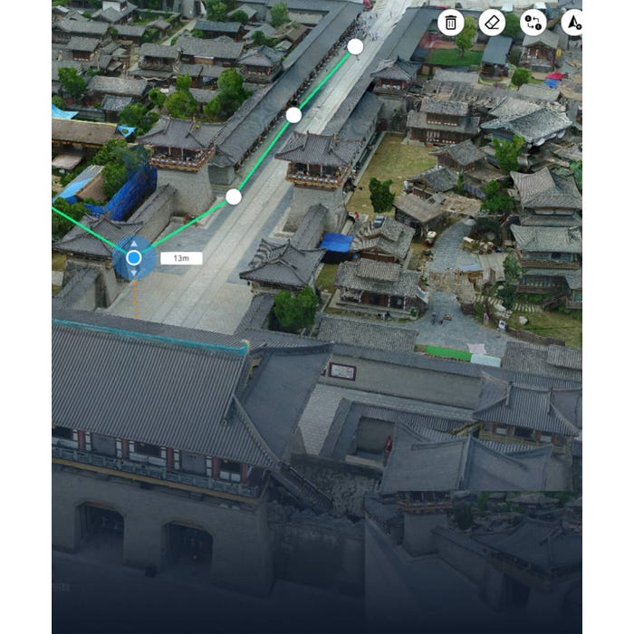
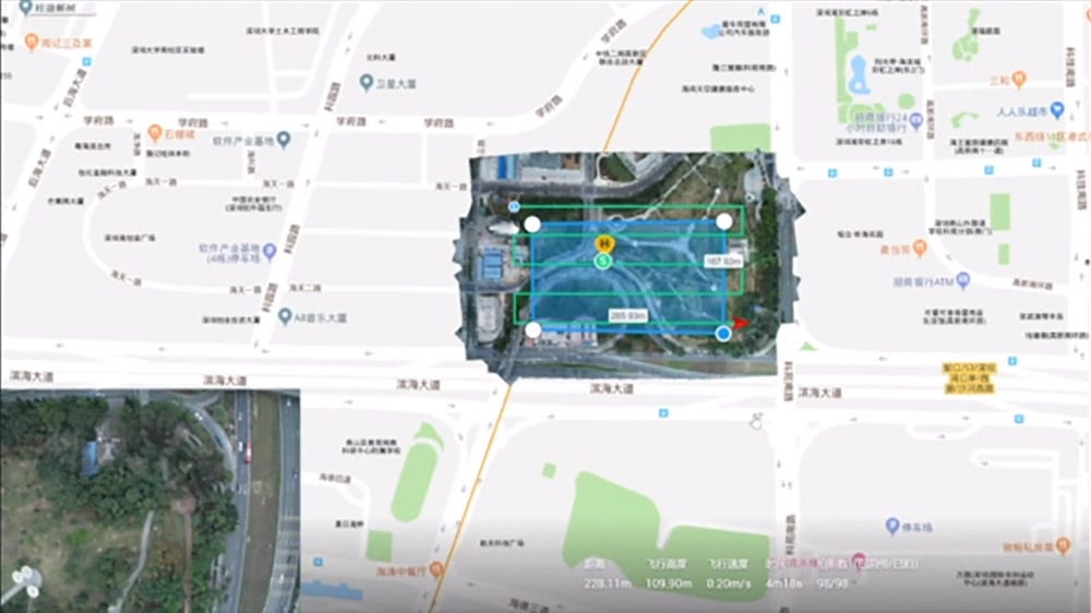
With its powerful features, DJI Terra allows users to create precise flight paths, perform real-time mapping, and generate 2D and 3D reconstructions. The software supports waypoint, area, and oblique mission planning, giving you the flexibility to capture data in various environments and scenarios. Analyze terrains with accurate measurement tools, annotate models for enhanced communication, and inspect individual photos for detailed insights.
Designed for professionals who demand efficiency and accuracy, DJI Terra ensures your projects are completed with confidence and precision.

Key Features
- Mission Planning: Create detailed flight paths with adjustable parameters like altitude, speed, and gimbal pitch for optimized data collection.
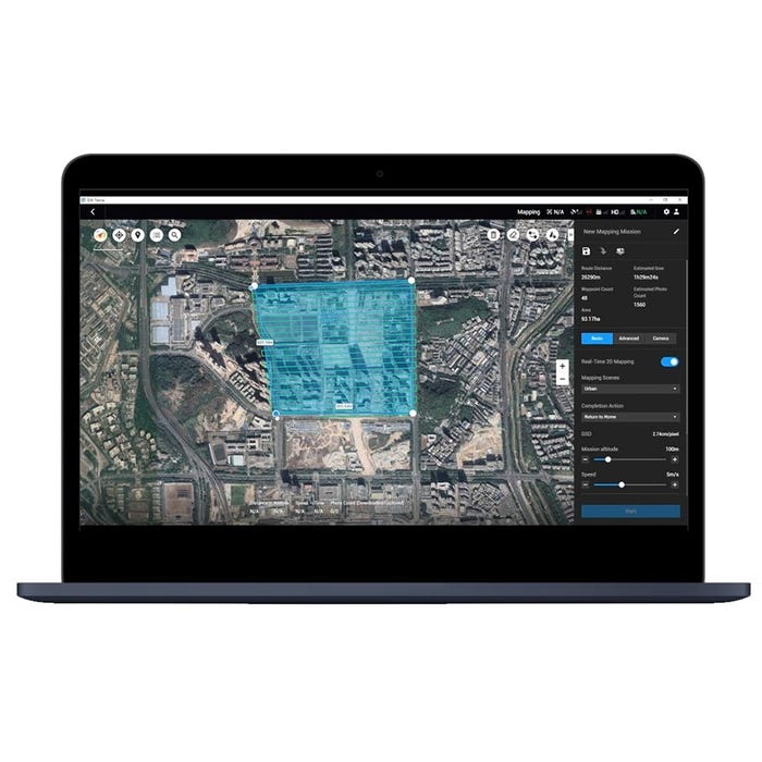
- Real-Time Mapping: Generate 2D orthomosaics during flight for immediate decision-making on-site.
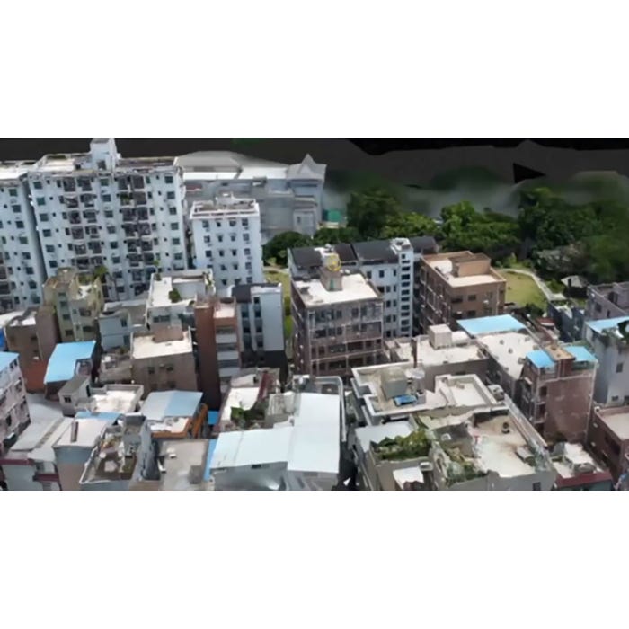
- 2D and 3D Reconstruction: Produce high-resolution maps and realistic 3D models for industrial applications.
- Measurement Tools: Conduct linear, area, and volumetric analyses with ease.
- Annotation and Photo Inspection: Edit labels and inspect images to highlight critical project elements.
- Broad Industry Applications: Ideal for public safety, construction, infrastructure, agriculture, and filmmaking.
Detailed Specification
Mission Planning Modes
| Mode | Description |
|---|---|
| Waypoint Mission | Create efficient flight paths with adjustable parameters and simulate tasks on existing 3D models. |
| Area Mission | Automate complex missions with a few taps for seamless image capture and map generation. |
| Oblique Mission | Capture rich 3D model data with angled camera views for detailed visualizations. |
Reconstruction and Mapping
| Feature | Description |
|---|---|
| Real-Time Mapping | Quickly create 2D orthomosaics during flight missions. |
| 2D Reconstruction | Generate high-resolution orthomosaics for accurate measurements. |
| 3D Reconstruction | Create realistic 3D models for industrial applications. |
| 2D & 3D Measurements | Perform linear, area, and volumetric measurements with intuitive tools. |
| Annotation | Add and edit labels on models to enhance communication and reporting. |
| Photo Inspection | Pinpoint and analyze critical elements by inspecting individual model photos. |
Compatibility
| Compatible Drones | Supported Models |
|---|---|
| Phantom 4 Series | Phantom 4 RTK, Phantom 4 Pro V2.0, Phantom 4 Pro+ V2.0, Phantom 4 Pro, Phantom 4 Advanced. |
In Package
- 1x DJI Terra Mapping Software License (1-Year Subscription, Advanced or Pro)
Drone Services
https://rippingitoutdoors.com/pages/drone-services
Manuals & Documents
General Warranty Info:
- Ripping It Outdoors works closely with our manufacturers to supply and support your products warranty needs as best as possible!
- The majority of products come with a manufacturer represented warranty against manufacturing defects for at least a 12 month period after the date of sale.
- Expendable components and "wear parts" including but not limited to blades, knives, teeth, oil, chain sprockets, skid shoes, knife mounting discs, and similar components are usually excluded from manufacturer warranties.
- Please reach out to us for any specific warranty information needed about products and parts you can’t find!
Videos
Shipping
General Shipping Info:
- Instantly calculate shipping quotes to the lower 48 states by 1. adding this product to your cart, 2. click continue to the checkout page and 3. enter your shipping address to check rates. Contact us for quotes for shipping to Hawaii, Alaska, Canada, Mexico and Internationally.
- Complimentary lift gate service on all freight shipments where it’s possible. We guarantee safe delivery!
- Low shipping rates for customers. We have negotiated the best possible rates for customers from our trusted carriers (ODFL, ESTES, UPS, and FedEx).
- Negotiate shipping rates if you think we can do better please reach out. Keep in mind some shipping rates also include assembly & configuration as well!