***Online pricing not available, Please request a quote:***
How To Get A Quote: Option 1: “Contact Us to make sure you are getting the best unit possible. These machines are complex so let us help you get exactly what you need!
Option 2: (quickest response times) Step 1. Add the item to your cart Step 2. Checkout or Click on the Chat button box that is at the bottom right of your screen Step 3. Please tell us any info you think we would need to know Step 4. Relax, our team is processing your request and an expert will be in touch to get you exactly what you need!
Product Description
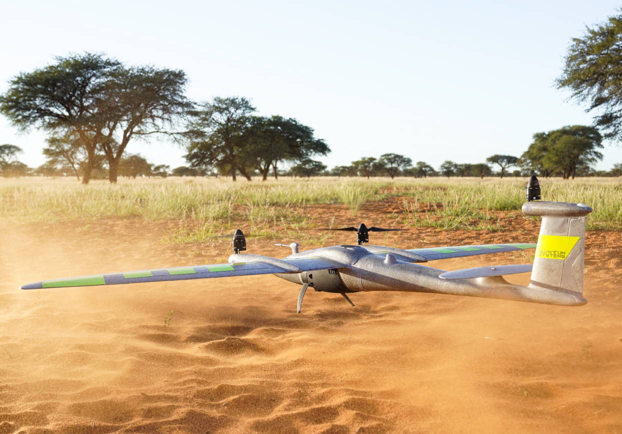
Quantum-Systems Series Trinity Pro Drone
DESCRIPTION
Trinity Pro is a future-proof mapping drone designed to adapt to changing requirements and accelerate decision-making through advanced aerial data.
It features an extended flight time of 90 minutes and easy to use mission planning software QBase 3D. The choice of integrated cameras is unrivaled – RGB, Oblique, Multispectral and even LiDAR – making it the right tool for any mapping application.
Accomplish Your Missions with Ease
The Trinity Pro incorporates the latest technology with the Quantum-Skynode autopilot and the Linux mission computer. This technology delivers increased computing power and internal storage, as well as enhanced connectivity onboard the aircraft.
Not only does this allow downstream integration of next-generation cameras, but also of logging, simulation and AI capabilities. These integrations reduce processing steps and office time, and provide answers quickly and accurately.
Built on The Legacy of The Trinity F90+
Trinity Pro Technical advances include an enhanced terrain-following system, which significantly improves safety during operations. Additionally, improvements to trigger point calculations results in improved image overlap and higher data quality. Trinity Pro also features automatic wind simulation for crash avoidance in bad weather and a linear approach for landing. Furthermore, Trinity Pro is equipped with a downfacing LiDAR scanner that provides highly accurate ground avoidance and landing control.
Key Features
Extended Flight Time: Up to 90 minutes of uninterrupted operation for larger survey areas.
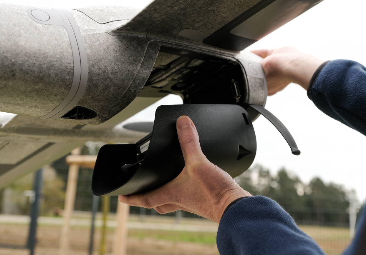
Versatile Payload Options: Accommodates RGB, multispectral, LiDAR, and oblique cameras for diverse applications.
Advanced Safety Systems: Includes terrain-following, wind simulation, and LiDAR-based ground avoidance.
Compact Transportability: Lightweight design with a molded transport case for portability.
Efficient Data Processing: Integrated PPK GNSS system ensures 1 cm accuracy with minimal ground control points.
INNOVATIVE AIRCRAFT FOR YOUR MISSIONS
Expand Your Capabilities and Power Your Every Move
Quantum-Systems' eVTOL Fixed-Wing UAVs combine the advantages of helicopters and airplanes. If provides vertical take-off and landing capability as well as sophisticated aerodynamics in perfect symbiosis – in one product.
90-min max. flight time
Max area coverage: 700 ha
Max. take-off weight: 5.75 kg (12.68 lb.)
Take-off altitude: 4800 m
Wind tolerance: 18 m/s
Easy-to-use mission planning software QBase 3D
Choice of integrated cameras: RGB, Oblique, Multispectral & LIDAR
How does VTOL increase drone survey success?
Take-off and land anywhere regardless of terrain
No belly landing
Easy and safe for the operator
Better payload protection
Ability to adapt to moving environment
Heavier cameras for higher image quality
Easy and Safe Handling
A push of a button is enough and the UAV will do its assigned job. The remote control has a clean layout without confusing switches and levers. The Trinity Pro and the remote controller work together seamlessly to get your job done automatically, while still providing emergency override capabilities.
Thanks to Quantum’s sophisticated electric VTOL design your investment is never in danger due to a flawed hand launch or a rough belly landing.
Reliable and Integrated Design
Quantum Systems designed the Trinity Pro to meet the requirements of professionals.
You can see the result in every detail, such as the optimized electric layout, the efficient cargo container or the clean finish of the outer shell. It truly showcases the best of German engineering.
Longest Flight Time in Class
The ability to switch to gliding mode enables the Trinity Pro to directly benefit from an enhanced long range capability. Many hours were dedicated to optimize the wing geometry to push the glide ratio to an outstanding 14:1.
Using only one specially-designed motor in the rear fuselage increases the flight time far beyond current industrial UAVs by reducing energy consumption to a minimum.
Small Footprint
The Trinity Pro comes “ready to fly” (RTF) in a molded transport case which offers enough space for the whole package with room to add two optional battery packs, accessories, and a tablet PC.
A padded cover with convenient carrying options makes it easy to transport the package to the farthest operation area. At a size of 100x83x27cm it can be stowed away easily.
More survey data in less time
The Trinity Pro demonstrates its range advantage in comparison to rotary and other fixed-wing drones due to the longer flight time and covers up to 20 times larger areas. The larger the area to be covered, the more attractive the use of Trinity Pro gets.
The Trinity Pro sets a new standard for high-accuracy survey equipment. Thanks to a high-end PPK GNSS L1/L2 receiver and full-frame mapping cameras, it is possibly for customers to achieve absolute accuracy down to 1 cm. GCPs are no longer needed to get highly-accurate results. To verify your results’ accuracy, place as few as three on the field and use them as checkpoints.
QBase 3D
The mission planning software is the main interface between the user and the drone. QBase 3D provides simple and intuitive planning in combination with advanced functionality for professional users.
3D Planning for More Safety
With the integrated 3D view, we offer an efficient tool to plan even more precisely and to keep a perfect overview during the flight. Intuitive and practical.
One Software - Many Application Scenarios
Quantum-System UAVs combined with QBase 3D help surveyors, farmers, scientists, quarrymen, civil engineers, and geologists to focus on their application, allowing them to just fly!
Stay Up to Date
QBase 3D is a constantly evolving product. Continuous system updates for all Quantum-Systems UAVs as well as Qbase 3D itself guarantee maximum future security. During operation, live weather data support mission planning.
Simple and Fast
Thanks to QBase 3D, all mission relevant steps from planning to flying can be carried out intuitively.
Detailed Specifications
Specification
Details
Max Take-Off Weight
12.7 lbs
Max Flight Time
90+ Minutes
Max Range
100 km (700 ha)
Max Flight Altitude
18,045 feet (5,500 m)
Command and Control Range
5 - 7.5 km
Payload Max
700 grams
Optimal Cruise Speed
17 m/s
Wind Tolerance (Ground)
11 m/s
Wind Tolerance (In Cruise)
18 m/s
Battery Capacity
10 Ah
RC Transmitter Frequency
2.4 GHz
Flight Data Link (Trinity - QBase) Frequency
2.4 GHz
Flight Data Link (Trinity - QBase) Power
100 mW
Operating Temperature Range
-12°C to 50°C
Wingspan
2.394 m (7.85 ft)
Length
4.85 ft
Transport Case Dimension
39.4 x 32.7 x 10.6 inch
Battery Specification
Specification
Details
Charging Current
12 A
Discharging Current
2 A
Discharging Voltage
3.1 V
TVC Voltage
4.2 V
Charging Time
Around 1 hour
Charging Current (USB Port)
2.1 A
Weight
3.3 lbs
In Package
Trinity PRO UAV
PPK
Anti-Collision Lights
USB ADS-B Receiver Set
iBase Reference GNSS Base Station
QBase 3D Software - Ground Control Station (runs on any Windows 10 computer/tablet)
Remote Controller
3 Battery Packs + 1 Charger unit
Air Data Probe
Anemometer
Lightweight Transport Case
Warranty (1 Year)
Technical Support
Manuals & Documents
General Warranty Info:
Ripping It Outdoors works closely with our manufacturers to supply and support your products warranty needs as best as possible!
The majority of products come with a manufacturer represented warranty against manufacturing defects for at least a 12 month period after the date of sale.
Expendable components and "wear parts" including but not limited to blades, knives, teeth, oil, chain sprockets, skid shoes, knife mounting discs, and similar components are usually excluded from manufacturer warranties.
Please reach out to us for any specific warranty information needed about products and parts you can’t find!
Videos
Shipping
$1 Shipping Quote Info:
Contact Us For Shipping Quotes. All $1 products are listed as quote only because we can not display their pricing online.
Low shipping rates for customers. We have negotiated the best possible rates for customers from our trusted carriers (ODFL, ESTES, UPS, and FedEx) & Top Private Drivers
Negotiate shipping rates if you think we can do better please reach out. Keep in mind some shipping rates also include assembly & configuration as well!
Complimentary lift gate service on all freight shipments where it’s possible. We guarantee safe delivery!
Choosing a selection results in a full page refresh.