


Garmin Montana® 700, 700i and 750i Rugged GPS Touchscreen Navigator with inReach Technology and 8 Megapixel Camera
Garmin Montana® 700, 700i and 750i Rugged GPS Touchscreen Navigator with inReach Technology and 8 Megapixel Camera
Couldn't load pickup availability
Couldn't load pickup availability


Product Description
Garmin Montana® 700, 700i and 750i Rugged GPS Touchscreen Navigator with inReach Technology and 8 Megapixel Camera
DESCRIPTION
Some jurisdictions regulate or prohibit the use of satellite communications devices. It is the responsibility of the user to know and follow all applicable laws in the jurisdictions where the device is intended to be used.
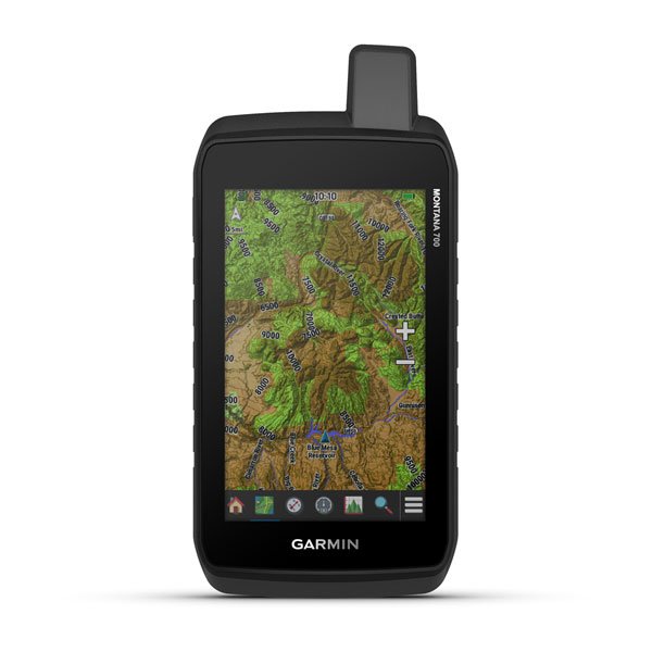
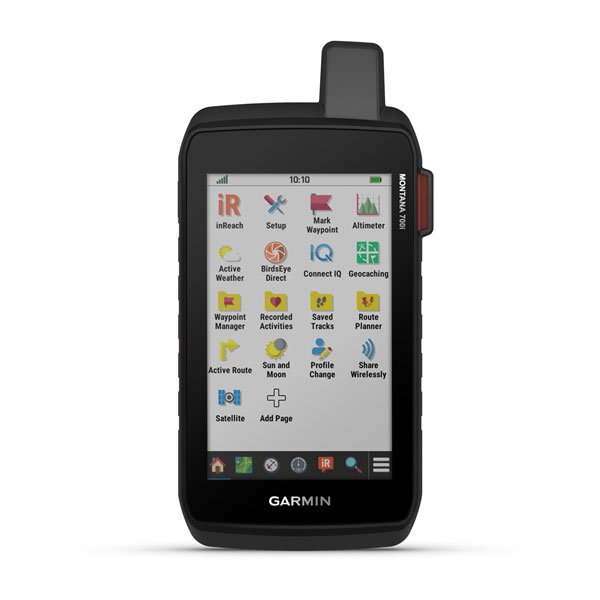
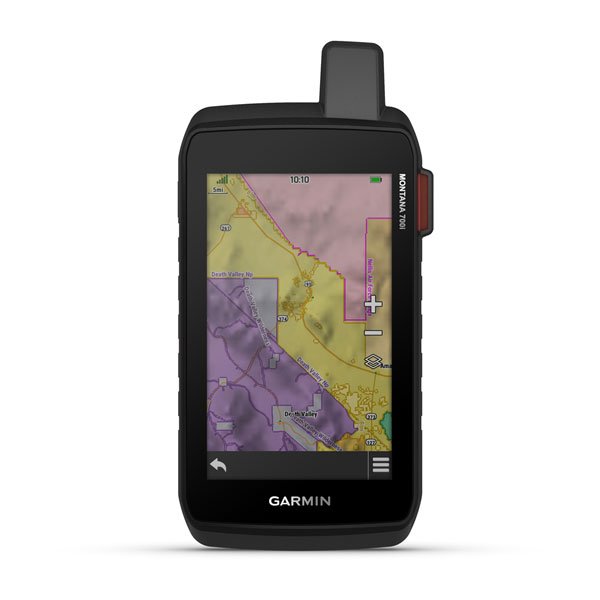
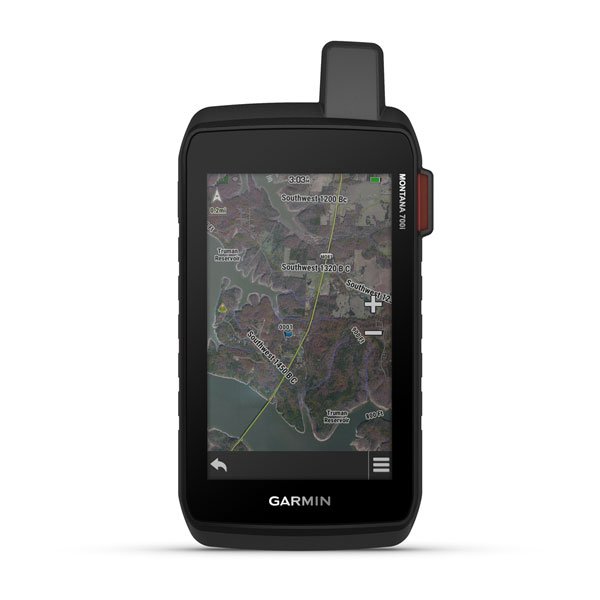
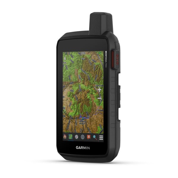
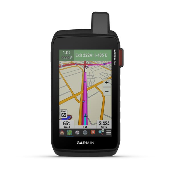
The Garmin Montana® 700, 700i, and 750i are rugged, touchscreen GPS navigators built for explorers, hunters, off-road enthusiasts, and outdoor adventurers. With a large 5” sunlight-readable display, multi-GNSS tracking, and TopoActive maps, these handheld GPS devices provide high-precision navigation on foot, bike, kayak, ATV, and more.
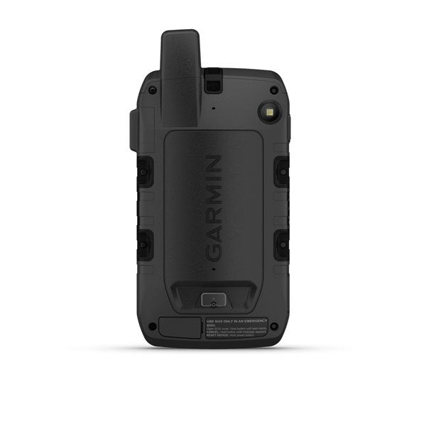
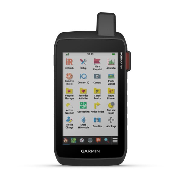
The Montana 700i and 750i models include inReach® satellite communication for two-way messaging and SOS alerts when off-grid. The 750i adds an 8-megapixel camera, allowing you to capture and geotag photos along your route.
With up to 18 hours of battery life in GPS mode and 330 hours in Expedition mode, these handheld navigators offer long-lasting performance for multi-day adventures.
Key Features

EXPLORE YOUR WORLD WITH NAVIGATION YOU TRUST
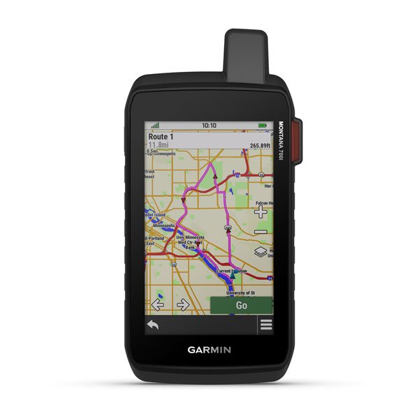
With routable mapping for roads and trails, the Montana 700 handheld brings advanced outdoor features into a sturdy 5” format that’s ideal for navigation on foot, bike, kayak, ATV, and more.
Track your adventures on any terrain.


RUGGED BY DESIGN
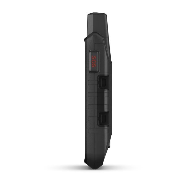
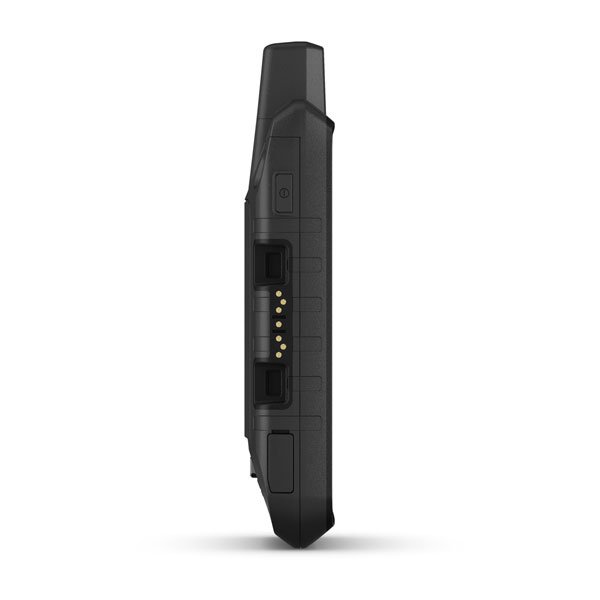
This durable, water-resistant handheld is tested to U.S. military standards and features a glove-friendly 5” touchscreen that’s 50% larger than previous Montana models

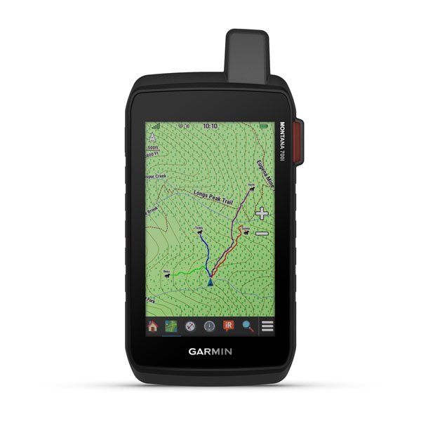
TOPOACTIVE MAPS
To navigate your adventures, use preloaded topographical maps for the U.S. and Canada. View terrain contours, elevations, coastlines, rivers, landmarks, and more.

PUBLIC LAND BOUNDARIES
Optional display of federal public land boundaries on topographical maps helps you know that you’re venturing where you’re supposed to be.

SATELLITE VIEWS
Use direct-to-device downloads of BirdsEye Satellite Imagery (no annual subscription required) to see photo-realistic views and create waypoints based on landmarks.

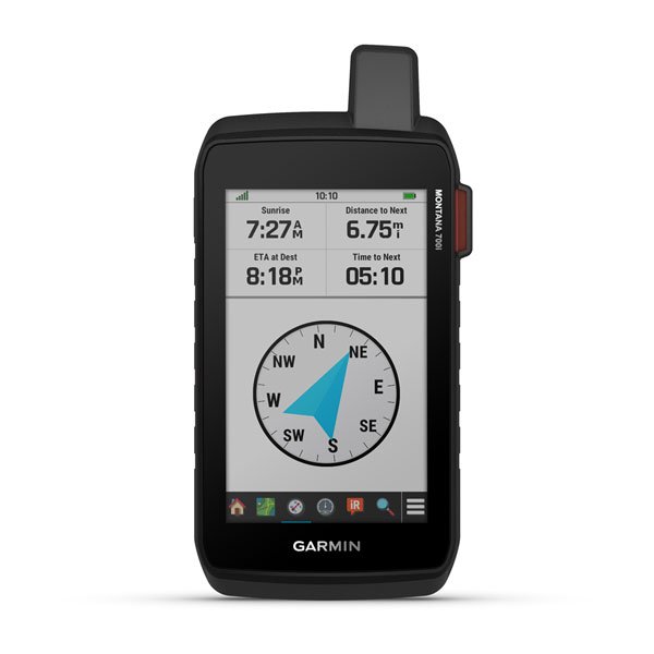
ABC SENSORS
Navigate your next trail with ABC sensors, including an altimeter for elevation data, a barometer to monitor the weather, and 3-axis electronic compass.

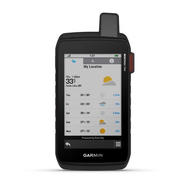
ACTIVE WEATHER
Use cellular connectivity1 to access up-to-date Active Weather forecasts through the Garmin Connect app.
![]()
DOG TRACKING
For hunters and trainers, this Montana syncs with compatible Astro® or Alpha® series handhelds (sold separately) to help track sporting dogs in the field.

WIKILOC TRAILS
This preloaded app lets you easily download hiking, cycling, and other Wikiloc trails shared by outdoor enthusiasts like you. Get a free 60-day Wikiloc Premium trial to try this and other exclusive features.
Take it hiking. Take it hunting. Take it off-grid.

MULTI-GNSS SUPPORT
Access to GPS, GLONASS, and GALILEO satellite networks enables Montana 700 to track in more challenging environments than GPS alone.
LOCATION SHARING
The LiveTrack feature lets you wirelessly connect1 your device with other compatible Garmin GPS users, so they can follow your tracks, routes, waypoints, and adventures.
EXPEDITION MODE
Trek far and wide off-grid. Use Expedition mode, an ultralow-power GPS reference, to keep Montana tracking for a week or more between recharges.
BATTERY OPTIONS
An internal, rechargeable lithium-ion battery pack provides more than 18 hours of battery life in GPS mode. It can also be powered with traditional AA batteries.
VEHICLE MOUNTS
A variety of Montana handheld-compatible mounts (sold separately) lets you adapt your navigator for use on ATVs, boats, cars, motorcycles, RVs, or other vehicles.
Detailed Specifications
Montana® 700
| Specification | Details |
|---|---|
| Brand Name | GARMIN Montana® 700 |
| Dimensions | 3.4" x 7.2" x 1.3" (8.76 x 18.30 x 3.27 cm) |
| Touchscreen | Yes |
| Display Size | 2.55"W x 4.25"H (5" diag, 12.70 cm) |
| Display Resolution | 480 x 800 pixels |
| Display Type | WVGA transflective, dual-orientation |
| Weight | 14.0 oz (397 g) with included lithium-ion battery pack |
| Battery Type | Rechargeable lithium-ion (included) or 3 AA batteries (not included, lithium recommended) |
| Battery Life (GPS Mode) | Up to 18 hours |
| Battery Life (Expedition Mode) | Up to 330 hours |
| Waterproof Rating | IPX7 |
| MIL-STD-810 | Yes (thermal, shock, water, vibe) |
| Interface | High-speed micro USB and NMEA 0183 compatible |
| Memory/History | 16 GB (userspace varies based on included mapping) |
Montana® 700i
| Specification | Details |
|---|---|
| Brand Name | GARMIN Montana® 700i |
| Physical Dimensions | 3.6" x 7.2" x 1.3" (9.19 x 18.30 x 3.27 cm) |
| Touchscreen | Yes |
| Display Size | 2.55"W x 4.25"H (5" diag, 12.70 cm) |
| Display Resolution | 480 x 800 pixels |
| Display Type | WVGA transflective, dual-orientation |
| Weight | 14.5 oz (410 g) with included lithium-ion battery pack |
| Battery Type | Rechargeable lithium-ion (included) |
| Battery Life (GPS Mode) | Up to 18 hours |
| Battery Life (10 min Tracking) | Up to 18 hours |
| Waterproof Rating | IPX7 |
| MIL-STD-810 | Yes (thermal, shock, water, vibe) |
| Interface | High-speed micro USB and NMEA 0183 compatible |
| Memory/History | 16 GB (userspace varies based on included mapping) |
Montana® 750i
| Specification | Details |
|---|---|
| Brand Name | GARMIN Montana® 750i |
| Dimensions | 3.6" x 7.2" x 1.3" (9.19 x 18.30 x 3.27 cm) |
| Touchscreen | Yes |
| Display Size | 2.55"W x 4.25"H (5" diag, 12.70 cm) |
| Display Resolution | 480 x 800 pixels |
| Display Type | WVGA transflective, dual-orientation |
| Weight | 14.5 oz (410 g) with included lithium-ion battery pack |
| Battery Type | Rechargeable lithium-ion (included) |
| Battery Life (GPS Mode) | Up to 18 hours |
| Battery Life (10 min Tracking) | Up to 18 hours |
| Battery Life (Expedition Mode) | Up to 330 hours |
| Battery Life (Expedition 30 min Tracking) | Up to 300 hours |
| Waterproof Rating | IPX7 |
| MIL-STD-810 | Yes (thermal, shock, water, vibe) |
| Interface | High-speed micro USB and NMEA 0183 compatible |
| Memory/History | 16 GB (userspace varies based on included mapping) |
| Camera | Yes (8-megapixel with autofocus; automatic geo-tagging) |
Common Features Across All Models
| Feature | Availability |
|---|---|
| Preloaded Maps | Yes (TopoActive by region; Federal Public Lands maps for U.S.) |
| Ability to Add Maps | Yes |
| Basemap | Yes |
| Automatic Routing for Outdoor Activities | Yes (with optional mapping for detailed roads) |
| Map Segments | 15,000 |
| Birdseye Direct-to-Device | Yes |
| Detailed Hydrographic Features | Yes |
| Searchable Points of Interest | Yes (parks, campgrounds, scenic lookouts, picnic sites) |
| National, State, and Local Parks Display | Yes |
| External Memory Storage | Yes (32 GB max microSD™ card) |
| Waypoints/Favorites/Locations | 10,000 |
| Tracks | 250 |
| Track Log | 20,000 points, 250 saved GPX tracks, 300 saved FIT activities |
| Navigation Routes | 250 (250 points per route, 50 points auto-routing) |
| RINEX Logging | Yes |
Sensors & Tracking
| Sensor/Feature | Availability |
|---|---|
| GPS | Yes |
| GLONASS | Yes |
| GALILEO | Yes |
| Barometric Altimeter | Yes |
| Compass | Yes (tilt-compensated 3-axis) |
| GPS Compass (while moving) | Yes |
| Smart Notifications on Handheld | Yes |
| Weather | Yes |
| VIRB® Remote | Yes |
| Pairs with Garmin Connect™ Mobile | Yes |
| Active Weather | Yes |
| LiveTrack | Yes |
Outdoor Recreation Features
| Feature | Availability |
|---|---|
| Point-to-Point Navigation | Yes |
| Compatible with BaseCamp™ | Yes |
| Area Calculation | Yes |
| Hunt/Fish Calendar | Yes |
| Sun and Moon Information | Yes |
| XERO™ Locations | Yes |
| Geocaching-Friendly | Yes (Geocache Live) |
| Custom Maps Compatible | Yes (500 custom map tiles) |
| Picture Viewer | Yes |
| InReach Remote Widget | Yes |
| LED Beacon Flashlight | Yes |
Connectivity
| Feature | Availability |
|---|---|
| Wireless Connectivity | Yes (Wi-Fi®, BLUETOOTH®, ANT+®) |
In Package
- Montana 700,700I and 750i
- Lithium-ion battery pack
- USB cable
- Documentation
Manuals & Documents
- Bicycle Handlebar Mount Instructions
- External Antenna Adapter Cable Instructions
- Marine Mount Instructions
- Motorcycle/ATV Mount Instructions
- Owner's Manual
- Suction Cup Mount with Speaker Instructions
- Important Safety and Product Information
- AA Battery Pack Instructions
General Warranty Info:
- Ripping It Outdoors works closely with our manufacturers to supply and support your products warranty needs as best as possible!
- The majority of products come with a manufacturer represented warranty against manufacturing defects for at least a 12 month period after the date of sale.
- Expendable components and "wear parts" including but not limited to blades, knives, teeth, oil, chain sprockets, skid shoes, knife mounting discs, and similar components are usually excluded from manufacturer warranties.
- Please reach out to us for any specific warranty information needed about products and parts you can’t find!
Videos
Shipping
General Shipping Info:
- Instantly calculate shipping quotes to the lower 48 states by 1. adding this product to your cart, 2. click continue to the checkout page and 3. enter your shipping address to check rates. Contact us for quotes for shipping to Hawaii, Alaska, Canada, Mexico and Internationally.
- Complimentary lift gate service on all freight shipments where it’s possible. We guarantee safe delivery!
- Low shipping rates for customers. We have negotiated the best possible rates for customers from our trusted carriers (ODFL, ESTES, UPS, and FedEx).
- Negotiate shipping rates if you think we can do better please reach out. Keep in mind some shipping rates also include assembly & configuration that as well