


SkyeBrowse 3D Modeling Videogrammetry Drone Software
SkyeBrowse 3D Modeling Videogrammetry Drone Software
Couldn't load pickup availability
Couldn't load pickup availability


How To Get A Quote
***Online pricing not available, Please request a quote***
How To Get A Quote:
Option 1:
Contact Us to make sure you are getting the best unit possible. These machines are complex so let us help you get exactly what you need!
Option 2: (quickest response times)
Step 1. Add the item to your cart
Step 2. Checkout or Click on the Chat button box that is at the bottom right of your screen
Step 3. Please tell us any info you think we would need to know
Step 4. Relax, our team is processing your request and an expert will be in touch to get you exactly what you need!
Products Description
SkyeBrowse 3D Modeling Videogrammetry Drone Software
DESCRIPTION
SkyeBrowse Videogrammetry: Revolutionizing Data Collection with Accurate 3D Models
Enhance your situational awareness and decision-making with SkyeBrowse videogrammetry, a cutting-edge solution that converts drone or phone video footage into accurate 3D models. Designed for simplicity and reliability, SkyeBrowse allows you to capture detailed scene data quickly, minimizing on-site time and mitigating risks for responders.
Using the SkyeBrowse DJI/Autel mobile app, you can automate drone flights to collect data over large areas in minutes. Alternatively, upload video from any supported source via the SkyeBrowse web panel for secure CJIS-compliant AWS cloud processing. The platform creates centimeter-accurate point cloud models, perfect for evidentiary use in court or immediate tactical decision-making.
The SkyeBrowse platform integrates seamlessly with crime scene reconstruction tools and supports pre-planning efforts by creating “digital twins” of critical infrastructure. Build actionable 3D models without disturbing trace evidence and stay ahead of the curve in incident response.
Key Features
- Video-to-3D Technology: Converts video footage into centimeter-accurate 3D models, ensuring precision and reliability.
- Cross-Platform Compatibility: Works with DJI, Autel, Draganfly drones, GoPro, Android phones, and other 4K-capable video sources.
- Secure Cloud Processing: CJIS-compliant AWS cloud-based processing ensures evidentiary integrity.
- Integrated Workflow: Compatible with tools like Leica, FARO, Trimble, and traffic reconstruction software for seamless data integration.
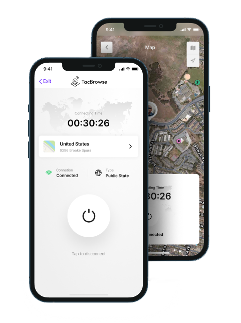
- Real-Time Awareness: Use TACBrowse for live personnel tracking and response planning in 3D.
- Training and Support: Access free online training, with advanced certifications and expert court testimony support available.
- Actionable Data: Generate immediate 3D models for tactical decisions or after-action reviews.

Detailed Specifications
| Feature | Details |
|---|---|
| Video Sources | DJI, Autel, Draganfly drones, Android phones, digital cameras (4K/30fps), GoPro, iPhone (soon) |
| Processing | CJIS-compliant AWS Cloud |
| Outputs | 3D Models, point clouds, shareable measurements (GeoTIFF coming soon) |
| Evidentiary Features | Chain of custody logging, secure original video retention |
| Integration | Compatible with Leica, FARO, Trimble, and other 3D reconstruction software |
| Applications | Crime scene analysis, traffic accident reconstruction, tactical planning, infrastructure mapping |
In Package
- Access to the SkyeBrowse DJI/Autel Mobile App for automated drone data collection.
- Web-Based Tools for video upload and 3D model generation.
- TACBrowse for real-time personnel tracking and active incident response.
- Complimentary Introductory Online Training and resources.
- On-demand Technical Expert Support for courtroom testimony.
Manuals & Documents
General Warranty Info:
- Ripping It Outdoors works closely with our manufacturers to supply and support your products warranty needs as best as possible!
- The majority of products come with a manufacturer represented warranty against manufacturing defects for at least a 12 month period after the date of sale.
- Expendable components and "wear parts" including but not limited to blades, knives, teeth, oil, chain sprockets, skid shoes, knife mounting discs, and similar components are usually excluded from manufacturer warranties.
- Please reach out to us for any specific warranty information needed about products and parts you can’t find!
Videos
Shipping
$1 Shipping Quote Info:
- Contact Us For Shipping Quotes. All $1 products are listed as quote only because we can not display their pricing online.
- Low shipping rates for customers. We have negotiated the best possible rates for customers from our trusted carriers (ODFL, ESTES, UPS, and FedEx) & Top Private Drivers
- Negotiate shipping rates if you think we can do better please reach out. Keep in mind some shipping rates also include assembly & configuration as well!
- Complimentary lift gate service on all freight shipments where it’s possible. We guarantee safe delivery!