


DJI | D-RTK 2 Mobile Station High-Precision GNSS Receiver For Industrial and Agricultural Applications
DJI | D-RTK 2 Mobile Station High-Precision GNSS Receiver For Industrial and Agricultural Applications
Regular price
$3,600.00
Regular price
Sale price
$3,600.00
Unit price
per
Couldn't load pickup availability
Couldn't load pickup availability


Product Description
DJI | D-RTK 2 Mobile Station High-Precision GNSS Receiver For Industrial and Agricultural Applications
DESCRIPTION
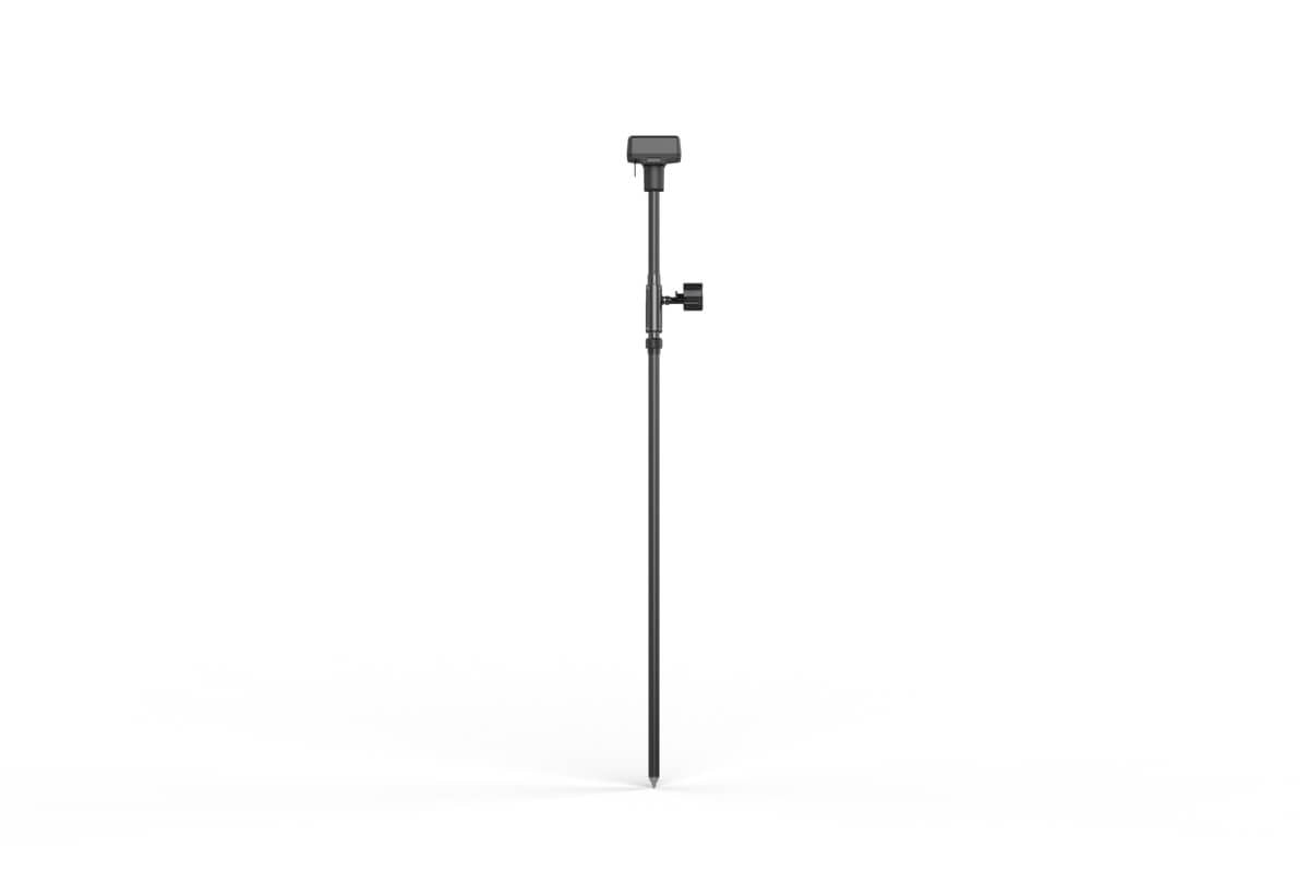
The DJI D-RTK 2 Mobile Station is an advanced high-precision GNSS receiver that delivers centimeter-level accuracy, making it an indispensable tool for surveyors, agricultural operators, and industrial users. With its ability to fully support GPS, GLONASS, Beidou, and Galileo signals, the D-RTK 2 ensures accurate positioning data through real-time differential corrections.
Built to withstand challenging environments, this mobile station features IP65 ingress protection and a carbon fiber body, ensuring long-lasting durability. Its robust connectivity options—4G, OcuSync, Wi-Fi, and LAN—provide stable communication across multiple devices, enabling coordinated operations with several drones, such as the Matrice 300 RTK and Phantom 4 RTK.
The integrated IMU technology enhances operational safety by monitoring movement and calibrating tilt sensors in real time. Whether it’s for surveying, aerial inspections, or precision agriculture, the D-RTK 2 Mobile Station offers unmatched reliability and accuracy.


Zoom in to Stay Safe
Capture clear images and videos from a safe distance. The M2EA’s high-resolution visual camera supports ultra zoom, so no detail is missed.
- Visual Camera: 48MP
- Lossless Zoom3:4x
-
CMOS Sensor: 1/2”
- Digital Zoom: 32×

Dual-vision at Your Service
Tap to switch between visual, thermal, or split-view feeds for different project needs.

Compact Yet Powerful

Accurate Positioning
Achieve centimeter-level accuracy using the M2EA with the RTK Module4. Create up to 240 waypoints to conduct automated, detailed inspection missions in complex environments.

Maximum Flexibility
The lightweight and portable M2EA can take off in less than a minute. Zip through complex operating environments thanks to the faster ascent and descent speed.

Additional Features

Key Features
- Centimeter-Level Positioning: Delivers highly accurate data for applications like mapping, inspections, and crop analysis.
- Broad Compatibility: Works seamlessly with DJI enterprise drones, including Agras T20, Phantom 4 RTK, and Matrice 300 RTK.
- Multi-Device Support: Enables connections with up to five remote controllers or multiple aircraft for synchronized missions.
- Durable and Portable Design: Lightweight carbon fiber construction and IP65 rating make it rugged yet easy to transport.
- Advanced Connectivity Options: Features 4G, OcuSync, Wi-Fi, and LAN for uninterrupted data transmission.
Detailed Specification
GNSS Receiver
| Feature | Details |
|---|---|
| Supported Systems | GPS (L1 C/A, L2, L5), GLONASS (F1, F2), Beidou (B1, B2, B3), Galileo (E1, E5A, E5B) |
| Positioning Accuracy | RTK Horizontal: 1 cm + 1 ppm / Vertical: 2 cm + 1 ppm |
| Cold Start Time | < 45 seconds |
| Hot Start Time | < 10 seconds |
| Update Rate | 1 Hz, 2 Hz, 5 Hz, 10 Hz, 20 Hz |
| Initialization Reliability | > 99.9% |
Physical Characteristics
| Feature | Details |
|---|---|
| Dimensions (with Rod) | 168×168×1708 mm |
| IP Rating | IP65 |
| Weight | Lightweight carbon fiber build |
Connectivity
| Feature | Details |
|---|---|
| Data Links | 4G, OcuSync, Wi-Fi, LAN |
| Communication Distance | 12 km (FCC/NCC), 6 km (SRRC/CE/MIC) |
Power and Battery
| Feature | Details |
|---|---|
| Battery Type | Lithium-ion (WB37, 4920 mAh) |
| Battery Runtime | WB37: >2 hours / MG-12000P: >50 hours |
| Power Consumption | 12 W |
In Package
- 1× D-RTK 2 Body
- 1× Extension Rod
- 1× Charging Hub
- 2× WB37 Intelligent Batteries
- 1× AC Power Adapter
- 1× AC Power Cable
- 1× USB-C Cable
- 1× USB-C OTG Cable
- 1× Battery Cover
- 1× Hex Key
Manuals & Documents
General Warranty Info:
- Ripping It Outdoors works closely with our manufacturers to supply and support your products warranty needs as best as possible!
- The majority of products come with a manufacturer represented warranty against manufacturing defects for at least a 12 month period after the date of sale.
- Expendable components and "wear parts" including but not limited to blades, knives, teeth, oil, chain sprockets, skid shoes, knife mounting discs, and similar components are usually excluded from manufacturer warranties.
- Please reach out to us for any specific warranty information needed about products and parts you can’t find!
Videos
Shipping
General Shipping Info:
- Instantly calculate shipping quotes to the lower 48 states by 1. adding this product to your cart, 2. click continue to the checkout page and 3. enter your shipping address to check rates. Contact us for quotes for shipping to Hawaii, Alaska, Canada, Mexico and Internationally.
- Complimentary lift gate service on all freight shipments where it’s possible. We guarantee safe delivery!
- Low shipping rates for customers. We have negotiated the best possible rates for customers from our trusted carriers (ODFL, ESTES, UPS, and FedEx).
- Negotiate shipping rates if you think we can do better please reach out. Keep in mind some shipping rates also include assembly & configuration as well!