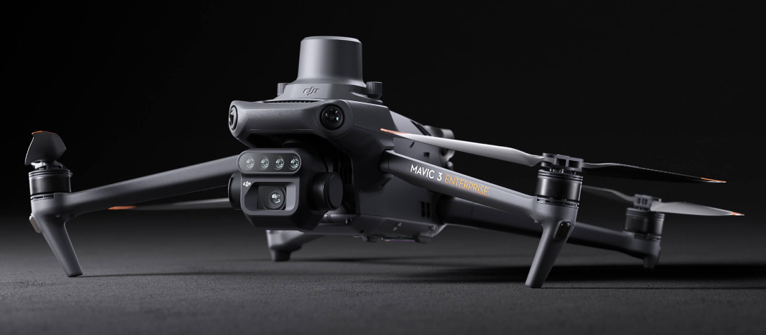
Effective aerial surveying needs to see the invisible. That's why Mavic 3 Multispectral has two forms of sight. It combines an RGB camera with a multispectral camera to scan and analyze crop growth with total clarity. Agricultural production management requires precision and data, and Mavic 3M delivers both.

How To Get A Quote:
Option 1:
“Contact Us to make sure you are getting the best unit possible. These machines are complex so let us help you get exactly what you need!
Option 2: (quickest response times)
Step 1. Add the item to your cart
Step 2. Checkout or Click on the Chat button box that is at the bottom right of your screen
Step 3. Please tell us any info you think we would need to know
Step 4. Relax, our team is processing your request and an expert will be in touch to get you exactly what you need!
Product Description
DJI Mavic 3M Multispectral Surveying Drone | For Agriculture & Environment
DESCRIPTION
The DJI Mavic 3M is a cutting-edge multispectral surveying drone tailored for agriculture, forestry, and environmental monitoring. Compact and highly portable, this drone integrates advanced imaging systems, including a 20 MP RGB camera and 4×5 MP multispectral cameras for precise data collection across diverse applications.
With its centimeter-level RTK positioning and omnidirectional obstacle sensing, the Mavic 3M ensures accuracy and safety in any operational environment. Capable of covering 200 hectares per flight and offering 43 minutes of flight time, it delivers efficiency and reliability for large-scale projects.
Ideal for applications such as crop monitoring, field scouting, orchard mapping, and environmental surveys, the Mavic 3M empowers users to achieve precise data insights, enabling smarter decision-making and cost-effective operations.
The built-in sunlight sensor captures solar irradiance and records it in an image file, allowing for light compensation of image data during 2D reconstruction. This results in more accurate NDVI results, as well as improved accuracy and consistency of data acquired over time.
DJI Automotive provi
RTK module
Accurate images that capture every pixel
Mavic 3M with RTK module for centimeter-level positioning. Flight control, the camera, and the RTK module sync in microseconds to accurately capture the location of each camera's imaging center. This enables Mavic 3M to do high-precision aerial surveying without using ground control points.
Efficient and reliable battery life
Ultra-long battery life, fast bursts
- 43 minutes [4]
- Cruise time
A single flight can complete mapping operations over an area of 200 hectares.

Fast charging
High-efficiency fast charging
Aircraft
Stable signal, smooth image transmission
The O3 transmission integrates two transmitting signals and four receiving signals to support 15km ultra-long transmission distances.
Omnidirectional obstacle sensing [1], terrain-follow aerial surveying
The aircraft features multiple wide-FOV vision sensors that accurately detect obstacles in all directions for omnidirectional obstacle avoidance. The terrain-follow aerial surveying can be easily performed in steep-slope landscapes.
Applications
Intelligent field scouting
The Mavic 3M can carry out automatic field scouting. The field scout images can be uploaded to the DJI SmartFarm Platform [6] in real time through a 4G network. It can find abnormalities, such as emergence deficiencies, weed pressure, and crop lodging in a timely manner. It can also conduct intelligent analyses, such as cotton seedling identification and rice production testing, using AI identification for real-time sharing of crop growth information, guidance of agronomic activities, and easy management of 70 hectares of farmland by one person.
Key Features
- Integrated Multispectral Imaging System: Capture detailed data with green, red, red edge, and near-infrared bands for advanced vegetation analysis.
- Long Flight Time: Achieve up to 43 minutes of operation for extended missions.
- RTK Module: Provides centimeter-level positioning for precision mapping and surveying.
- Omnidirectional Obstacle Avoidance: Navigate safely with sensors detecting obstacles in all directions.
- Versatile Applications: Ideal for agricultural mapping, forestry management, environmental surveys, and natural resource monitoring.
Detailed Specification
Aircraft Specifications
| Feature | Details |
|---|---|
| Net Weight | 951 g (with RTK module) |
| Dimensions (Folded/Unfolded) | 223×96.3×122.2 mm / 347.5×283×139.6 mm |
| Max Takeoff Weight | 1,050 g |
| Max Flight Time | 43 minutes |
| Max Wind Resistance | 12 m/s |
| Max Flight Distance | 32 km |
| Operating Temperature | -10° to 40° C (14° to 104° F) |
| GNSS | GPS + Galileo + BeiDou + GLONASS |
Imaging System
| Camera | Details |
|---|---|
| RGB Camera | 20 MP, 4/3 CMOS, Mechanical Shutter |
| Multispectral Bands | G (560 ± 16 nm), R (650 ± 16 nm), RE (730 ± 16 nm), NIR (860 ± 26 nm) |
| Max Image Size | RGB: 5280×3956 / Multispectral: 2592×1944 |
| Shutter Speed | Electronic: 1/8000s / Mechanical: 1/2000s |
Transmission System
| Feature | Details |
|---|---|
| Video Transmission System | DJI O3 Industry Edition |
| Max Transmission Distance | 15 km (FCC) |
| Live View Quality | 1080p/30fps |
RTK Module
| Feature | Details |
|---|---|
| Position Accuracy | Horizontal: 1 cm + 1 ppm / Vertical: 1.5 cm + 1 ppm |
| Interface | USB-C |
| Weight | 24 g |
Battery and Charging
| Feature | Details |
|---|---|
| Battery Capacity | 5000 mAh |
| Charging Hub | 100W High-Efficiency Charging Hub |
| Charging Time | Approx. 1.5 hours |
In Package
- 1x DJI Mavic 3M Drone
- 1x RTK Module
- 1x Intelligent Flight Battery
- 1x High-Efficiency Battery Charging Hub
- 1x Remote Controller
- 1x Set of Propellers
- 1x USB-C Cable
- 1x Gimbal Protector
Manuals & Documents
General Warranty Info:
- Ripping It Outdoors works closely with our manufacturers to supply and support your products warranty needs as best as possible!
- The majority of products come with a manufacturer represented warranty against manufacturing defects for at least a 12 month period after the date of sale.
- Expendable components and "wear parts" including but not limited to blades, knives, teeth, oil, chain sprockets, skid shoes, knife mounting discs, and similar components are usually excluded from manufacturer warranties.
- Please reach out to us for any specific warranty information needed about products and parts you can’t find!
Videos
Shipping
General Shipping Info:
- Instantly calculate shipping quotes to the lower 48 states by 1. adding this product to your cart, 2. click continue to the checkout page and 3. enter your shipping address to check rates. Contact us for quotes for shipping to Hawaii, Alaska, Canada, Mexico and Internationally.
- Complimentary lift gate service on all freight shipments where it’s possible. We guarantee safe delivery!
- Low shipping rates for customers. We have negotiated the best possible rates for customers from our trusted carriers (ODFL, ESTES, UPS, and FedEx).
- Negotiate shipping rates if you think we can do better please reach out. Keep in mind some shipping rates also include assembly & configuration as well!


