


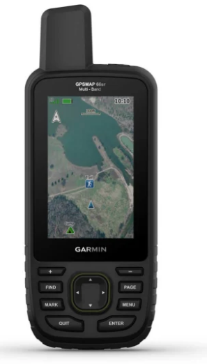
Garmin GPSMAP® 66sr Multi-Band GPS Handheld with Sensors and Topo Maps
Garmin GPSMAP® 66sr Multi-Band GPS Handheld with Sensors and Topo Maps
Couldn't load pickup availability
Couldn't load pickup availability


Product Description
Garmin GPSMAP® 66sr Multi-Band GPS Handheld with Sensors and Topo Maps
DESCRIPTION
The Garmin GPSMAP® 66sr Multi-Band Handheld GPS is the ultimate navigation companion for outdoor enthusiasts. Whether you're hiking, climbing, kayaking, or geocaching, this rugged handheld offers exceptional features, including multi-band GNSS support for superior positioning in remote or urban environments.
The preloaded TOPOActive maps for the U.S. and Canada provide detailed topographic data, including contours, summits, and waterways, while the Birdseye Satellite Imagery offers high-resolution, photo-realistic maps for added navigation precision. With public land boundaries and advanced features like ABC sensors (altimeter, barometer, compass) and Active Weather updates, you'll have all the tools you need to navigate confidently.
This device is designed to military-grade durability standards (MIL-STD-810) and includes features like a built-in LED flashlight and compatibility with the Garmin Explore app for planning and syncing routes. Its extended battery life ensures reliability, even on multi-day adventures.
Key Features
- Multi-Band GNSS: Supports GPS, GLONASS, and Galileo for superior accuracy, even in tough conditions.
- ABC Sensors: Altimeter for elevation data, barometer for weather monitoring, and compass for navigation.
- Birdseye Satellite Imagery: Download high-resolution imagery directly to the device without a subscription.
- Preloaded TOPO Maps: Includes U.S. and Canada terrain contours, rivers, lakes, and points of interest.
- Public Land Boundaries: Optional display for federal public land areas.
- Active Weather: Provides real-time weather forecasts and radar.
- LED Flashlight: Built-in flashlight for emergencies or low-light conditions.
- Military-Grade Durability: Withstands thermal, shock, and water challenges; compatible with night vision goggles.
- Wikiloc Trails: Preloaded app with access to thousands of hiking and cycling trails, including a 60-day free premium trial.
-
MULTI-GNSS SUPPORT
Access multiple global navigation satellite systems (GPS, GLONASS and Galileo) to track in more challenging environments than GPS alone.
MULTI-BAND FREQUENCY SUPPORT
Receive and utilize multiple frequencies sent by navigation satellites which enables improved user position accuracy, specifically in areas where GNSS signals are reflected, weak or typically do not penetrate. Get superior accuracy using state of the art technology, previously only available to the military.
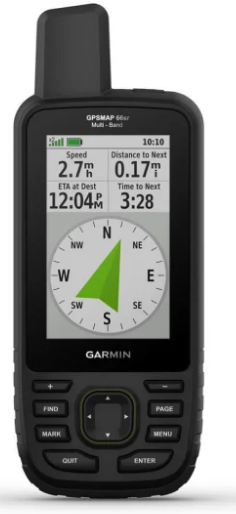
ABC SENSORS
Navigate every trail with ABC sensors, including an altimeter for elevation data, barometer to monitor weather and 3-axis electronic compass.
BIRDSEYE SATELLITE IMAGERY
Download high-resolution photo-realistic maps directly to your device without an annual subscription. Easily find trails, pick stand locations, find parking, create waypoints and more.
PRELOADED TOPO MAPS
Preloaded TopoActive U.S. and Canada maps show you terrain contours, topographic elevations, summits, parks, coastlines, rivers, lakes and geographical points.
PUBLIC LAND BOUNDARIES
Optional display of federal public land boundaries on topographical maps helps you know that you’re venturing where you’re supposed to be.
ACTIVE WEATHER
When paired with your compatible smartphone, you can get real-time forecast information and live weather radar, so you’re always aware of the surrounding conditions.
WIKILOC TRAILS
This preloaded app lets you easily download hiking, cycling and other Wikiloc trails shared by outdoor enthusiasts like you. Get a free 60-day Wikiloc Premium trial to try this and other exclusive features.
BUILT FOR ADVENTURE
This handheld is built to military standards for thermal, shock and water performance (MIL-STD-810), and it’s even compatible with night vision goggles.
LED FLASHLIGHT
The GPSMAP 66 series helps you keep gear to a minimum with a built-in LED flashlight that can be used as a beacon to signal for help.
GEOCACHING
Get automatic cache updates from Geocaching Live, including descriptions, logs and hints. When connected via Wi-Fi® technology or to the Garmin Connect™ app, each find will upload to your Geocaching.com profile.
GARMIN EXPLORE APP
Plan, review and sync waypoints, routes and tracks by using the Garmin Explore app and website. You can even review completed activities while still in the field.
BATTERY LIFE
Get up to 16 hours of battery life in GPS mode and 1 week in Expedition mode (with 2 AA batteries).
Detailed Specifications
| Attribute | Details |
|---|---|
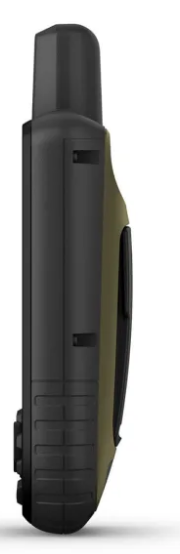
| Dimensions | 2.5" x 6.4" x 1.4" (6.2 x 16.3 x 3.5 cm) |
| Display Size | 1.5"W x 2.5"H (3.8 x 6.3 cm); 3" diagonal |
| Weight | 8.1 oz (230 g) with batteries |
| Memory | 16 GB (varies with included mapping) |
| Battery Life | Up to 36 hours (GPS mode); 450 hours (Expedition mode) |
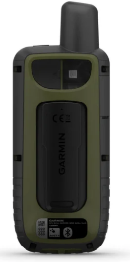
| Connections | Wi-Fi®, BLUETOOTH®, ANT+® |
In Package
- Garmin GPSMAP® 66sr
- USB Cable
- Carabiner Clip
- Documentation
Manuals & Documents
General Warranty Info:
- Ripping It Outdoors works closely with our manufacturers to supply and support your products warranty needs as best as possible!
- The majority of products come with a manufacturer represented warranty against manufacturing defects for at least a 12 month period after the date of sale.
- Expendable components and "wear parts" including but not limited to blades, knives, teeth, oil, chain sprockets, skid shoes, knife mounting discs, and similar components are usually excluded from manufacturer warranties.
- Please reach out to us for any specific warranty information needed about products and parts you can’t find!
Videos
Shipping
General Shipping Info:
- Instantly calculate shipping quotes to the lower 48 states by 1. adding this product to your cart, 2. click continue to the checkout page and 3. enter your shipping address to check rates. Contact us for quotes for shipping to Hawaii, Alaska, Canada, Mexico and Internationally.
- Complimentary lift gate service on all freight shipments where it’s possible. We guarantee safe delivery!
- Low shipping rates for customers. We have negotiated the best possible rates for customers from our trusted carriers (ODFL, ESTES, UPS, and FedEx).
- Negotiate shipping rates if you think we can do better please reach out. Keep in mind some shipping rates also include assembly & configuration as well!