


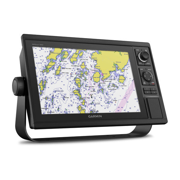
Garmin GPSMAP®1022, 1222, 1022xsv, 1042xsv, 1242xsv and 1222xsv Chartplotters with Sonar & Worldwide Basemap and Transducer (Optional)
Garmin GPSMAP®1022, 1222, 1022xsv, 1042xsv, 1242xsv and 1222xsv Chartplotters with Sonar & Worldwide Basemap and Transducer (Optional)
Couldn't load pickup availability
Couldn't load pickup availability


Product Description
Garmin GPSMAP®1022, 1222, 1022xsv, 1042xsv, 1242xsv and 1222xsv Chartplotters with Sonar & Worldwide Basemap and Transducer (Optional)
DESCRIPTION
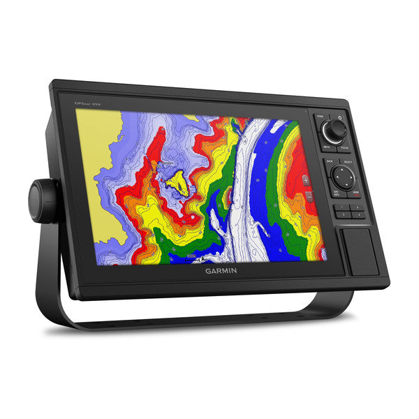
The Garmin GPSMAP® 10” and 12” chartplotters offer a versatile and powerful solution for sailors, anglers, and cruisers. With built-in CHIRP sonar technology, advanced mapping, and seamless network integration, these devices deliver industry-leading performance and functionality.
Optional radar bundles further enhance the experience with the addition of the GMR™ 18 HD+ dome radar, ensuring superior navigation and safety on the water.
Key Features
Advanced Display and Interface
- Display Sizes: Available in 10” and 12” screen options with high-resolution WSVGA displays.
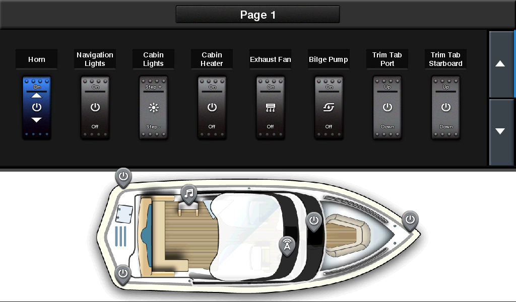
- Customizable Interface: Keypad control with multifunction knob and programmable keys for easy operation, even in harsh conditions.
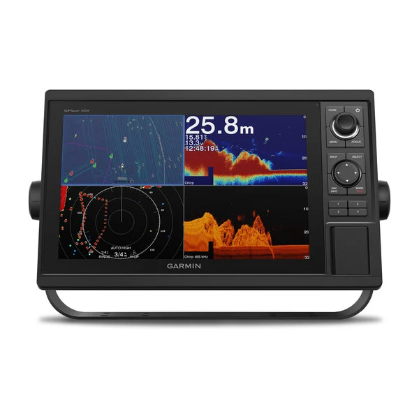
Sonar Technology
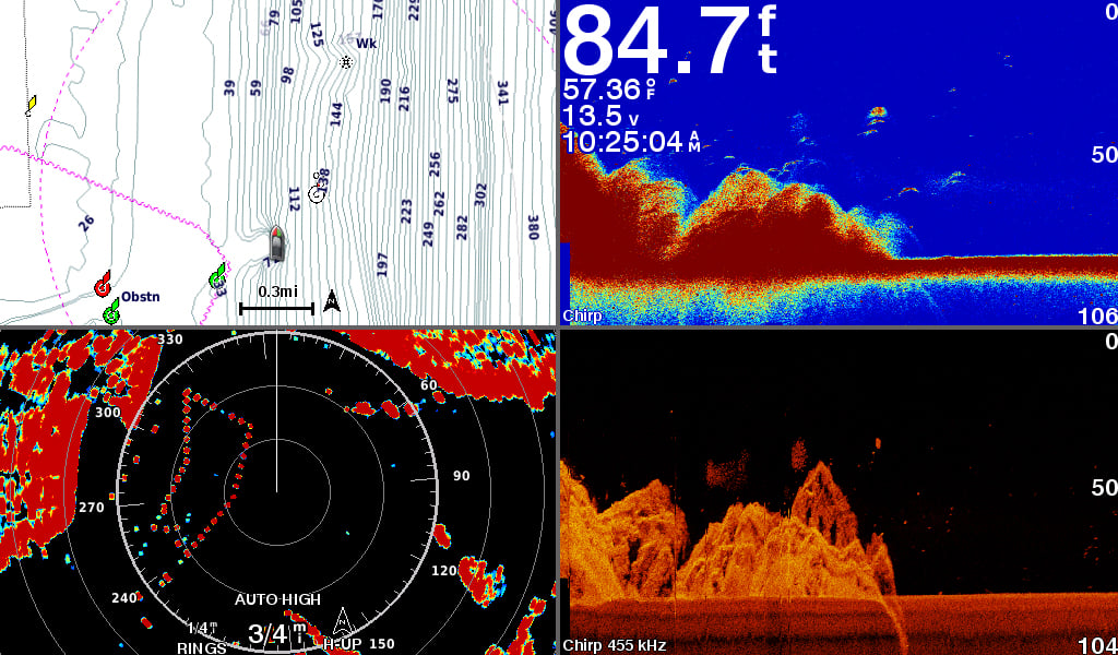
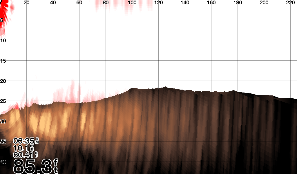
- Built-In Sonar: Includes 1 kW Garmin CHIRP sonar and CHIRP ClearVü/SideVü for superior underwater clarity.
- Panoptix™ Support: Compatible with Panoptix all-seeing sonar and premium sonar modules for real-time underwater views.
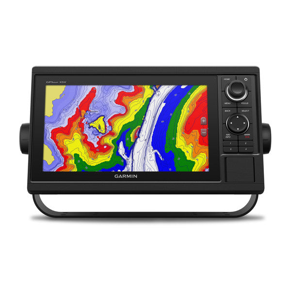
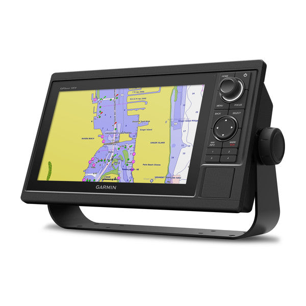
Preloaded Cartography
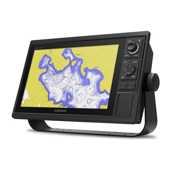
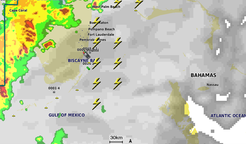
- BlueChart® g3 and LakeVü g3 Maps: Provide extensive coverage, clarity, and detail, including 1-foot contours for over 17,000 lakes.
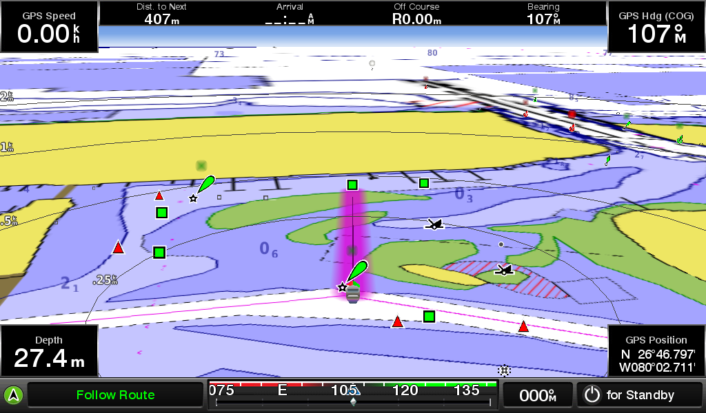
- Auto Guidance Technology: Suggests safe routes based on vessel specifications, such as draft and height.
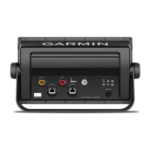
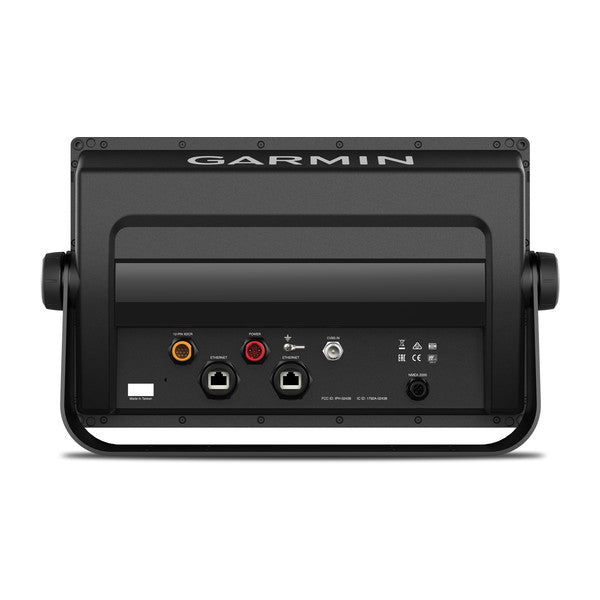
Networking and Connectivity
- Garmin Marine Network: Share sonar, maps, radar, cameras, and more across multiple devices.
- NMEA Compatibility: Fully compatible with NMEA 2000® and NMEA 0183 for integration with autopilots, AIS, VHF, weather, and other marine systems.
- Built-In Wi-Fi and ANT® Technology: Connects to mobile devices via the ActiveCaptain® app and integrates with Garmin marine watches, remote controls, and other accessories.
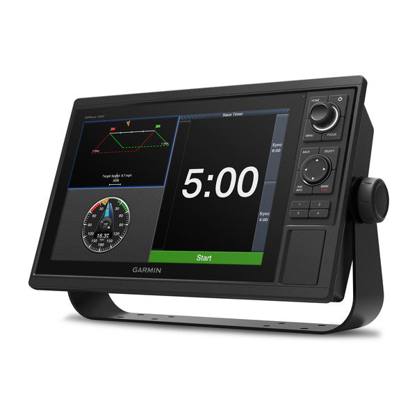
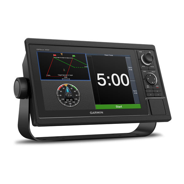
Sailing Tools
- SailAssist™ Features: Includes laylines, enhanced wind rose, race start line guidance, and other tools for competitive sailing.
10 & 12-inch Chartplotter Plus Sonar Combo(Optional) and Radar Bundle (Optional) Is “All-in-1” Solution
- 12” color display with keypad interface and multifunction control knob
- Built-in support for Garmin CHIRP sonar and CHIRP ClearVü and CHIRP SideVü scanning sonars (transducers sold separately)
- Preloaded BlueChart® g3 charts and LakeVü g3 maps
- High-sensitivity internal 10 Hz GPS and GLONASS receiver
- Fully network capable for Garmin Marine Network and NMEA 2000® connectivity plus NMEA 0183 support
Experience an advanced all-in-one solution with our 12” GPSMAP 1242xsv keyed combo. It has built-in support for Garmin CHIRP sonar and CHIRP ClearVü and CHIRP SideVü sonars. It also has built-in support for Panoptix™ all-seeing sonar and premium Garmin sonar modules (transducers sold separately). Features include a large, bright screen coupled with a quick and easy-to-use keypad interface with user-programmable keys and a multifunction control knob.
Complete Network Sharing
Garmin Marine Network support allows sharing of sonar, maps, user data, dome or open-array radar, IP cameras and Panoptix sonar among multiple units. Plus, there’s NMEA 2000 network connectivity and NMEA 0183 support for autopilots, digital switching, weather, media, VHF, AIS and other sensors.
Built-in Sonar Capabilities
Right out of the box, you have access to some amazing sonar capabilities; all you have to add are transducers. GPSMAP 1242xsv comes with built-in Garmin 1 kW CHIRP sonar along with CHIRP ClearVü and CHIRP SideVü scanning sonars. It even supports Panoptix all-seeing sonar, premium Garmin sonar modules and a wide range of transducers (sold separately).
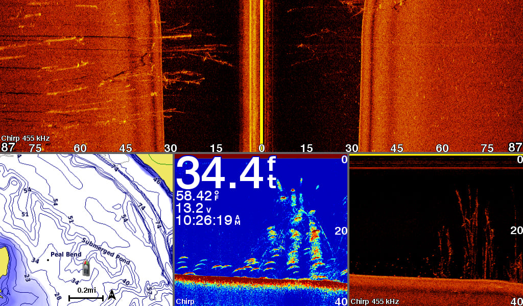
Networked combos can share their internal sonar with any other device on the network. You can also choose what information is overlaid on the sonar screen; for example, radar, time of day or GPS speed.
Preloaded with Exceptional Garmin Cartography
LakeVü g3 inland maps and BlueChart® g3 coastal charts provide industry-leading coverage, clarity and detail with integrated Garmin and Navionics® data and Auto Guidance1 technology. LakeVü g3 and BlueChart g3 include Auto Guidance1, which uses your desired depth and overhead clearance to calculate routes and provide a suggested path to follow. LakeVü g3 provides coverage on more than 17,000 lakes with up to 1’ contours. BlueChart g3 also includes NOAA raster cartography, available as a free downloadable feature via the ActiveCaptain® app.
Upgrade to Our Best Maps on the Water
Accessory map purchases, such as LakeVü g3 Ultra or BlueChart® g3 Vision, add even more features and detail to your maps and charts. LakeVü g3 Ultra and BlueChart g3 Vision add high-resolution relief shading, which provides an easy-to-interpret, clearer view of bottom structure than contour lines alone — plus many other chart and map-enhancing features.
Built-in ANT® Connectivity
Enjoy built-in ANT wireless connectivity directly to our quatix® marine watches, gWind™ Wireless 2 transducer, GNX™ Wind marine instrument, and wireless remote controls. You can even stream and control a VIRB® action camera from the Chartplotter.
The Ultimate Connected Boating App
Built in Wi-Fi® connectivity gives you access to the free all-in-one ActiveCaptain® app, so you can manage your marine experience from nearly anywhere. It creates a simple yet powerful connection between your compatible mobile device and your Garmin chartplotter, charts, maps and the boating community. Wherever you are, you’ll have unlimited access to your cartography, the ability to purchase new maps and charts and access to the Garmin Quickdraw™ Contours Community. Stay connected with smart notifications on your chartplotter screen. You can also plan a trip or prefish a lake, and ActiveCaptain will automatically sync with your chartplotter. Even get notifications for software updates, and decide when to download them on your device.
Heading, Position Refreshed 10 Times per Second
Fast, responsive built-in 10 Hz GPS and GLONASS refreshes your position and heading 10 times each second to make your movement on the screen more fluid. It makes dropping up to 5,000 accurate waypoints — and finding your way back to them — quick and easy.
Quickdraw Contours to Create Your Own HD Maps
Instantly create personalized HD fishing maps on screen with 1’ contours. Tailor them to fit your needs. These are your maps — you own them. Keep the data to yourself, or share it with the Quickdraw Community on our Garmin Connect™ online network.
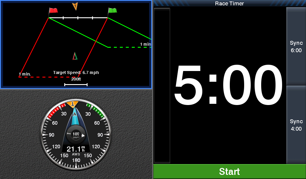
Built-in SailAssist Features
To help you gain a wind-maximizing competitive edge, your Chartplotter features a prerace guidance page that shows your virtual starting line along with data fields showing laylines, time to burn before the start, and a race timer that can be synchronized across all your networked Garmin GPS products. In addition, other supported sailing features include an enhanced wind rose, heading and course-over-ground lines, set and drift, true and apparent wind data, and more.
GPX Waypoints Transfer
If you have waypoints, tracks or frequently used routes stored on another manufacturer’s GPS product — or on a Garmin handheld device — it’s easy to transfer those items to your new Garmin chartplotter via industry-standard GPX software formatting.
Detailed Specifications
GPSMAP 1022xsv vs. GPSMAP 1222xsv
| GPSMAP 1022xsv | GPSMAP 1222xsv | |
|---|---|---|
| Display Size | 10" | 12" |
| Resolution | 1024 x 600 | 1280 x 800 |
| Weight | 4.1 lbs | 5.2 lbs |
| Max Depth | 5,000 ft | 5,000 ft |
| Preloaded Maps | Worldwide basemap | Worldwide basemap |
| Networking | NMEA 2000®, NMEA 0183 | NMEA 2000®, NMEA 0183 |
GPSMAP 1042xsv vs. GPSMAP 1242xsv
| GPSMAP 1042xsv | GPSMAP 1242xsv | |
|---|---|---|
| Display Size | 10" | 12" |
| Resolution | 1024 x 600 | 1280 x 800 |
| Weight | 4.1 lbs | 5.2 lbs |
| Max Depth | 5,000 ft | 5,000 ft |
| Preloaded Maps | BlueChart® g3 and LakeVü g3 maps | BlueChart® g3 and LakeVü g3 maps |
| Networking | Garmin Marine Network | Garmin Marine Network |
In Package
GPSMAP® 1022 10" Non-sonar with Worldwide Basemap
- GPSMAP Selected Model chartplotter
- Power/data cable
- NMEA 2000 T-connector
- NMEA 2000 drop cable (2 m)
- Bail mount kit with knobs
- Flush mount kit with gasket
- Protective cover
- Trim piece snap covers
- Documentation
Manuals & Documents
General Warranty Info:
- Ripping It Outdoors works closely with our manufacturers to supply and support your products warranty needs as best as possible!
- The majority of products come with a manufacturer represented warranty against manufacturing defects for at least a 12 month period after the date of sale.
- Expendable components and "wear parts" including but not limited to blades, knives, teeth, oil, chain sprockets, skid shoes, knife mounting discs, and similar components are usually excluded from manufacturer warranties.
- Please reach out to us for any specific warranty information needed about products and parts you can’t find!
Videos
Shipping
General Shipping Info:
- Instantly calculate shipping quotes to the lower 48 states by 1. adding this product to your cart, 2. click continue to the checkout page and 3. enter your shipping address to check rates. Contact us for quotes for shipping to Hawaii, Alaska, Canada, Mexico and Internationally.
- Complimentary lift gate service on all freight shipments where it’s possible. We guarantee safe delivery!
- Low shipping rates for customers. We have negotiated the best possible rates for customers from our trusted carriers (ODFL, ESTES, UPS, and FedEx).
- Negotiate shipping rates if you think we can do better please reach out. Keep in mind some shipping rates also include assembly & configuration as well!