Garmin GPSMAP 8400 and 8600 series with Worldwide Basemap with Mapping Multi Sizes
DESCRIPTION
ADVANCED MARINE NAVIGATION AND SONAR COMBO The Garmin GPSMAP Series Chartplotter/Sonar Combos are designed for serious sport fishermen, cruisers, sailors, and sail racers who demand the best marine navigation technology. With Full HD IPS touchscreen displays available in 10", 12", 16", 17", 22", and 24" models, these devices provide wide viewing angles and sunlight readability, even with polarized sunglasses.
The GPSMAP Series combines powerful sonar capabilities, detailed charting, and full system integration into a sleek and modern package. Preloaded with BlueChart g3 and LakeVü g3 maps, these devices offer the best of Garmin and Navionics technology for precise and detailed navigation.
Key Features
Full HD Touchscreen Displays: Available in various sizes (10”-24”) with anti-glare, polarized support, and edge-to-edge flush-mount installation options.
Built-in Sonar Capabilities: Includes CHIRP, CHIRP ClearVü, CHIRP SideVü, and support for Ultra High-Definition scanning sonar. Compatible with Panoptix™ all-seeing sonar (transducers sold separately).
SmartMode Station Controls: Seamlessly integrates radar, sonar, cameras, and digital switching for quick, one-touch access to critical information.
ActiveCaptain Connectivity: Pair with the free ActiveCaptain app for smart notifications, software updates, and trip planning.
Sailing-Specific Features: Laylines, pre-race guidance, wind rose, and tide/current information for competitive sailors.
Dynamic System Integration: NMEA 2000 networking and Garmin Marine Network compatibility for connecting autopilots, radar, instruments, and more.
Expandable Memory: Accepts up to 2 microSD cards for additional maps and custom data storage.
10” 12” 16” 17” 22” 24” Touchscreen Chartplotter/Sonar Combo with Full HD In-plane Switching (IPS) Display
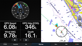
Features a 16” full HD IPS touchscreen display preloaded with both BlueChart® g3 U.S. coastal and LakeVü HD maps featuring Navionics® data and Auto Guidance¹ technology
Fully network capable with NMEA 2000® connectivity and the Garmin Marine Network
Built-in support for the full suite of Garmin sonar capabilities
Includes ANT® technology and Wi-Fi® networking
SmartMode™ station controls for quick, one-touch access to the information you need
Serious sport fishermen, cruisers, sailors, and sail racers demand serious equipment. The easy-to-use, easy-to-install GPSMAP 8616xsv Chartplotter/sonar combo delivers MFD performance in a combo-size package. It features a 16” full HD IPS touchscreen display for wider viewing angles, superior clarity, and sunlight readability, even with polarized sunglasses. Multiple displays can be flat mounted edge-to-edge to create a sleek glass helm look or can be mounted flush.
Complete Sonar Support:
The GPSMAP 8616xsv Chartplotter/sonar combo offers built-in support for our industry-leading sonar, including dual-channel 1 kW traditional CHIRP, CHIRP ClearVü, and CHIRP SideVü scanning sonars plus built-in support for Ultra High-Definition scanning sonar (no black box required). It also supports the entire panoptic all-seeing sonar line (transducers sold separately).
The Best of Garmin with the Best of Navionics:
For the most detailed, clear, and concise charts and maps, this Chartplotter is preloaded with BlueChart g3 coastal cartography and LakeVü g3 inland mapping featuring Navionics data. They also include our Auto Guidance technology, which shows a suggested route to a destination¹, based on your boat’s specifications. The expandable memory allows you to upgrade your maps with accessory map purchases, such as BlueChart® g3 Vision and LakeVü g3 Ultra.
Build Your Marine System:
NMEA 2000 networking and the Garmin Marine Network allow you to easily build your full marine electronics suite — from radar and autopilots to cameras, instruments, and forward-looking sonar — controlled from your Chartplotter and shared across multiple screens. In addition, our exclusive OneHelm™ system coordinates many third-party manufactured onboard marine products to bring full control of systems — such as digital switching, lighting, stabilization, and more — conveniently to your Chartplotter screen.
Full Connectivity:
The GPSMAP 8616xsv Chartplotter has a premium-performance processor that enables fast map drawing, superior networking, video distribution, and more. Built-in Wi-Fi technology lets you pair with the free ActiveCaptain app for access to OneChart™, smart notifications¹, Garmin Quickdraw Community data, and more. You can also control video streaming from our GC™ 100 wireless camera andVIRB action cameras. In addition, built-in ANT wireless technology connects you directly to our quatix marine watch, gWind Wireless 2 transducer, and wireless remote controls.
SmartMode Station Controls:
Networked sonar, radar, cameras, media, and digital switching can be independent or incorporated into SmartMode station controls. With SmartMode, everything is designed to give you quick, one-touch access to the information you need to ease high-stress situations such as docking.
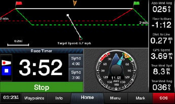
Special Sailing Features:
The Garmin SailAssist™ feature provides data, displays, and prerace guidance to help you gain a competitive edge. Other sailing features include laylines, enhanced wind rose, heading and course-over-ground lines, true wind data fields, and tide/current/time slider. Gauge displays provide need-to-know information at a glance, including true and apparent wind angle, set and drift, true or apparent wind speed, horizontal or vertical graphs, and a data bar with customizable fields.
The Ultimate Connected Boating App:
Download the ActiveCaptain app to your smartphone or tablet to manage your marine experience from anywhere — from trip planning and pre-fishing to updating software and purchasing maps.
Sit Back and Take Control:
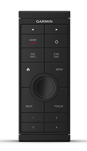
You don’t have to stand for hours at the helm. The optional easy-to-use GRID™ 20 remote input device provides intuitive remote access and control of your entire Garmin marine system. It features a 360-degree joystick with a rotary knob and push-to-select button for easy chartplotter menu/setting navigation and fine control, even in the worst conditions.
Special Sailing Features:
To help you make informed decisions, the Garmin SailAssist feature provides critical data displays and prerace guidance to help you gain a competitive edge. Other sailing features include laylines, enhanced wind rose, heading and course-over-ground lines, true wind data fields and tide/current/time slider. Gauge displays provide need-to-know information at a glance, including true and apparent wind angle, set and drift, true or apparent wind speed, horizontal or vertical graphs and a data bar with customizable fields.
Heading, Position Refreshed 10 Times per Second:
Fast, responsive 10 Hz GPS refreshes your position and heading 10 times each second to make your movement on the screen more fluid. Now, it’s quick and easy to drop up to 5,000 accurate waypoints and find your way back to them.
SailAssist Features:
Supported sailing features include laylines, enhanced wind rose, heading and course-over-ground lines, true wind data fields and tide/current/time slider. Racing features include pre-race guidance, synchronized race timer, virtual starting line, time to burn and layline data fields. Gauge displays are designed to provide important, need-to-know information at a glance, including true and apparent wind angle, set and drift, true or apparent wind speed, horizontal or vertical graphs and a data bar with customizable data fields.
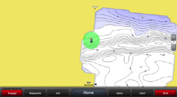
Create Your Own HD Maps:
Quickdraw Contours is a free, easy-to-use software feature that is already installed on your GPSMAP 8624. It instantly creates your very own personalized HD fishing maps with 1-foot contours. Tailor them to fit your needs. They are your maps. You own them. Keep the data to yourself or share it with Garmin or your friends. There’s no special surveying expertise required. You just fish while it creates maps. You don’t have to wait around or send your files away like other mapping software requires — your results appear instantly. Use with any Garmin Panoptix, any HD-ID™, any CHIRP-enabled, Garmin ClearVü™ transducer or NMEA 2000-compatible depth transducer. Have more than 1 sonar device installed onboard? Quickdraw Contours automatically selects the most capable sonar device to provide the very best results for you!
- GPSMAP 8410 unit - Power cable - NMEA 2000 drop cable - NMEA 2000 T-connector - Bail mount - Flush mount kit - Sun cover - Trim piece snap covers - Documentation
- GPSMAP 8412 unit - Power cable - NMEA 2000 drop cable - NMEA 2000 T-connector - Bail mount - Flush mount kit - Sun cover - Trim piece snap covers - Documentation
GPSMAP® 8410 vs. GPSMAP® 8412
Specification
GPSMAP® 8410
GPSMAP® 8412
Physical Dimensions
10.25" × 8.06" × 2.95" (25.9 × 20.5 × 7.5 cm)
11.9" × 8.5" × 3" (30.3 × 21.6 × 7.6 cm)
Display Size
8.6" × 5.4"; 10.1" diagonal
10.1" × 5.7"; 11.6" diagonal
Display Resolution
1920 × 1200 (WUXGA)
1920 × 1200 (FHD/WUXGA)
Display Type
IPS touchscreen (anti-glare)
IPS touchscreen (anti-glare)
Weight
5.2 lbs (2.4 kg)
6.0 lbs (2.7 kg)
Water Rating
IPX7
IPX7
Mounting Options
Bail, flush, or flat (tools required)
Bail, flush, or flat (tools required)
Power Consumption
~2.0 A @ 12 V DC
~2.4 A @ 12 V DC
NMEA 2000® Compatible
Yes
Yes
Garmin Marine Network™ Ports
2
2
Wireless Connectivity
Wi-Fi® + ANT®
Wi-Fi® + ANT®
GPS Receiver
10 Hz GPS/GLONASS/Galileo (internal or external)
Same as 8410
Preloaded Maps
Worldwide Basemap
Worldwide Basemap
Accepts Data Cards
2 microSD
2 microSD
Waypoints / Routes / Tracks
5,000 / 100 / 50
5,000 / 100 / 50
Sonar Compatibility
Requires black box (GSD™ / GCV™) or transducer
Requires black box (GSD™ / GCV™) or transducer
In the Box
- GPSMAP® 8410 unit - Power cable - NMEA 2000 drop cable - NMEA 2000 T-connector - Bail mount - Flush mount kit - Sun cover - Trim piece snap covers - Documentation
- GPSMAP® 8412 unit - Power cable - NMEA 2000 drop cable - NMEA 2000 T-connector - Bail mount - Flush mount kit - Sun cover - Trim piece snap covers - Documentation
GPSMAP® 8416 vs. GPSMAP® 8417
Specification
GPSMAP® 8416
GPSMAP® 8417
Physical Dimensions
15.1" × 10.3" × 3" (38.5 × 26.3 × 7.6 cm)
16.5" × 12.1" × 2.8" (41.9 × 30.7 × 7.1 cm)
Display Size
13.6" × 7.7"; 15.6" diagonal
14.4" × 9.1"; 17.0" diagonal
Display Resolution
1920 × 1080 (FHD)
1920 × 1200 (WUXGA)
Display Type
IPS touchscreen (anti-glare)
IPS touchscreen (anti-glare)
Weight
9.6 lbs (4.4 kg)
11.48 lbs (5.21 kg)
Water Rating
IPX7
IPX7
Mounting Options
Flush / Flat (Bail mount optional accessory)
Flush / Flat
Power Consumption
~3.5 A @ 12 V DC
Typical 2.8 A @ 12 V DC Max ~3.5 A @ 12 V DC
Garmin Marine Network™ Ports
2 or 4 (spec variance)
4
NMEA 2000® Compatible
Yes
Yes
GPS Receiver
10 Hz GPS/GLONASS/Galileo (internal/external)
10 Hz high-sensitivity (external only)
Preloaded Maps
Worldwide Basemap
Worldwide Basemap
Accepts Data Cards
2 microSD
2 SD (Garmin SD reader accessory)
Waypoints / Routes / Tracks
5,000 / 100 / 50
5,000 / 100 / 50
Sonar Compatibility
Requires black box (GSD™ / GCV™) or transducer
Requires black box (GSD™ / GCV™) or transducer
In the Box
- GPSMAP® 8416 unit - Power cable - NMEA 2000 drop cable - NMEA 2000 T-connector - Flush mount kit - Sun cover - Trim piece snap covers - Documentation
- GPSMAP® 8417 unit - Trim piece snap covers - GPS 24xd NMEA 2000 antenna - Protective cover - Flush mount hardware - Power cable - NMEA 2000 cables & T-connector - Documentation
PSMAP® 8422 vs. GPSMAP® 8424
Specification
GPSMAP® 8422
GPSMAP® 8424
Physical Dimensions
20.8" × 13.8" × 2.8" (52.8 × 35.1 × 7.1 cm)
22.8" × 16.1" × 2.8" (60.0 × 41.0 × 7.1 cm)
Display Size
18.8" × 10.6"; 21.5" diagonal
20.4" × 12.8"; 24.0" diagonal
Display Resolution
1920 × 1080 (FHD)
1920 × 1200 (WUXGA)
Display Type
IPS touchscreen (anti-glare)
IPS touchscreen (anti-glare)
Weight
15.63 lbs (7.09 kg)
18.95 lbs (8.60 kg)
Water Rating
IPX7
IPX7
Mounting Options
Flush / Flat
Flush / Flat
Power Consumption
Typical ~3.9 A @ 12 V DC Max ~4.9 A
Typical ~6.1 A @ 12 V DC Max ~7.6 A
Garmin Marine Network™ Ports
4
4
NMEA 2000® Compatible
Yes
Yes
GPS Receiver
10 Hz high-sensitivity (external only)
10 Hz high-sensitivity (external only)
Preloaded Maps
Worldwide Basemap
Worldwide Basemap
Accepts Data Cards
2 SD (Garmin SD reader accessory)
2 SD (Garmin SD reader accessory)
Waypoints / Routes / Tracks
5,000 / 100 / 50
5,000 / 100 / 50
Sonar Compatibility
Requires black box (GSD™ / GCV™) or transducer
Requires black box (GSD™ / GCV™) or transducer
In the Box
- GPSMAP® 8422 unit - Trim piece snap covers - GPS 24xd antenna - Protective cover - Flush mount hardware - Power cable - NMEA 2000 cables & T-connector kit - Documentation
- GPSMAP® 8424 unit - Trim piece snap covers - GPS 24xd antenna - Protective cover - Flush mount hardware - Power cable - NMEA 2000 cables & T-connector kit - Documentation
GPSMAP® 8610 vs. GPSMAP® 8612
Specification
GPSMAP® 8610
GPSMAP® 8612
Physical Dimensions
10.25" × 8.06" × 2.95" (25.9 × 20.5 × 7.5 cm)
11.9" × 8.5" × 3" (30.3 × 21.6 × 7.6 cm)
Display Size
8.6" × 5.4"; 10.1" diagonal
10.1" × 5.7"; 11.6" diagonal
Display Resolution
1920 × 1200 (WUXGA)
1920 × 1080 (FHD)
Display Type
IPS touchscreen (anti-glare)
IPS touchscreen (anti-glare)
Weight
5.2 lbs (2.4 kg)
6.0 lbs (2.7 kg)
Water Rating
IPX7
IPX7
Mounting Options
Bail, flush, or flat (tools required)
Bail, flush, or flat (tools required)
Power Consumption
~2.0 A @ 12 V DC
~2.4 A @ 12 V DC
Garmin Marine Network™ Ports
2
2
NMEA 2000® Compatible
Yes
Yes
Preloaded Maps
BlueChart® g3 + LakeVü g3
BlueChart® g3 + LakeVü g3
Accepts Data Cards
2 microSD (on back)
2 microSD (on back)
Waypoints / Routes / Tracks
5,000 / 100 / 50
5,000 / 100 / 50
Sonar Compatibility
Built-in CHIRP (transducer required)
Built-in CHIRP (transducer required)
In the Box
- GPSMAP® 8610 unit - Power cable - NMEA 2000 drop cable - NMEA 2000 T-connector - Bail mount w/ knobs - Flush mount kit - Sun cover - Trim piece snap covers - Documentation
- GPSMAP® 8612 unit - Power cable - NMEA 2000 drop cable - NMEA 2000 T-connector - Bail mount w/ knobs - Flush mount kit - Sun cover - Trim piece snap covers - Documentation
PSMAP® 8616 vs. GPSMAP® 8617
Specification
GPSMAP® 8616
GPSMAP® 8617
Physical Dimensions
15.1" × 10.3" × 3" (38.5 × 26.3 × 7.6 cm)
16.5" × 12.1" × 2.8" (41.9 × 30.7 × 7.1 cm)
Display Size
13.6" × 7.7"; 15.6" diagonal
14.4" × 9.1"; 17.0" diagonal
Display Resolution
1920 × 1080 (FHD)
1920 × 1200 (WUXGA)
Display Type
IPS touchscreen (anti-glare)
IPS touchscreen (anti-glare)
Weight
9.6 lbs (4.4 kg)
11.48 lbs (5.21 kg)
Water Rating
IPX7
IPX7
Mounting Options
Flush / Flat (bail accessory optional)
Flush / Flat
Power Consumption
~3.5 A @ 12 V DC
Typical ~2.8 A @ 12 V DC Max ~3.5 A @ 12 V DC
Garmin Marine Network™ Ports
2 (some references say 4)
4
NMEA 2000® Compatible
Yes
Yes
Preloaded Maps
BlueChart® g3 + LakeVü g3
BlueChart® g3 (US/West Canada) + LakeVü g3
Accepts Data Cards
2 microSD (on back)
2 SD (Garmin SD reader accessory)
Waypoints / Routes / Tracks
5,000 / 100 / 50
5,000 / 100 / 50
Sonar Compatibility
Built-in CHIRP (transducer sold separately)
Requires black box or transducer (GSD™ / GCV™)
In the Box
- GPSMAP® 8616 unit - Power cable - NMEA 2000 drop cable - NMEA 2000 T-connector - Flush mount kit - Sun cover - Trim piece snap covers - Documentation
- GPSMAP® 8617 unit - Trim piece snap covers - GPS 24xd antenna - Protective cover - Flush mount hardware - Power cable - NMEA 2000 cables & T-connector - Documentation
GPSMAP® 8622 vs. GPSMAP® 8624
Specification
GPSMAP® 8622
GPSMAP® 8624
Physical Dimensions
20.8" × 13.8" × 2.8" (52.8 × 35.1 × 7.1 cm)
22.8" × 16.1" × 2.8" (60.0 × 41.0 × 7.1 cm)
Display Size
18.8" × 10.6"; 21.5" diagonal
20.4" × 12.8"; 24.0" diagonal
Display Resolution
1920 × 1080 (FHD)
1920 × 1200 (WUXGA)
Display Type
IPS touchscreen (anti-glare)
IPS touchscreen (anti-glare)
Weight
15.63 lbs (7.09 kg)
18.95 lbs (8.60 kg)
Water Rating
IPX7
IPX7
Mounting Options
Flush / Flat
Flush / Flat
Power Consumption
Typical ~3.9 A @ 12 V DC Max ~4.9 A
Typical ~6.1 A @ 12 V DC Max ~7.6 A
Garmin Marine Network™ Ports
4
4
NMEA 2000® Compatible
Yes
Yes
GPS Receiver
10 Hz high-sensitivity (external only)
10 Hz high-sensitivity (external only)
Preloaded Maps
BlueChart® g3 (US/Western Canada) + LakeVü g3
BlueChart® g3 (US/Western Canada) + LakeVü g3
Accepts Data Cards
2 SD (Garmin SD reader accessory)
2 SD (Garmin SD reader accessory)
Waypoints / Routes / Tracks
5,000 / 100 / 50
5,000 / 100 / 50
Sonar Compatibility
Requires black box (GSD™ / GCV™) or transducer
Requires black box (GSD™ / GCV™) or transducer
In the Box
- GPSMAP® 8622 unit - Trim piece snap covers - GPS 24xd antenna - Protective cover - Flush mount hardware - Power cable - NMEA 2000 cables & T-connector kit - Documentation
- GPSMAP® 8624 unit - Trim piece snap covers - GPS 24xd antenna - Protective cover - Flush mount hardware - Power cable - NMEA 2000 cables & T-connector kit - Documentation
In Package
GPSMAP® 8410 10” With Worldwide Basemap:
GPSMAP 8410
Power cable
NMEA 2000® drop cable
NMEA 2000 T-connector
Bail mount with knobs
Flush mount kit
Sun cover
Trim piece snap covers
Documentation
GPSMAP® 8412 12” With Worldwide Basemap:
GPSMAP 8412
Power cable
NMEA 2000® drop cable
NMEA 2000 T-connector
Bail mount with knobs
Flush mount kit
Sun cover
Trim piece snap covers
Documentation
GPSMAP® 8416 16” With Worldwide Basemap:
GPSMAP 8416
Power cable
NMEA 2000® drop cable
NMEA 2000 T-connector
Flush mount kit
Sun cover
Trim piece snap covers
Documentation
GPSMAP® 8417 MFD 17” With Worldwide Basemap:
GPSMAP 8417
Trim piece snap covers
GPS 24xd NMEA 2000 (with pole mount, flush mount and under deck mount adapters)
Protective cover
Flush mount hardware
Power cable
NMEA 2000 2 m backbone/drop cable
NMEA 2000 6 m backbone cable
NMEA 2000 power cable
NMEA 2000 T-connector & terminator kit
Documentation
GPSMAP® 8422 MFD 22” With Worldwide Basemap:
GPSMAP 8422
Trim piece snap covers
GPS 24xd NMEA 2000 (with pole mount, flush mount and under deck mount adapters)
Protective cover
Flush mount hardware
Power cable
NMEA 2000 2 m backbone/drop cable
NMEA 2000 6 m backbone cable
NMEA 2000 power cable
NMEA 2000 T-connector & terminator kit
Documentation
GPSMAP® 8424 MFD 24” With Worldwide Basemap:
GPSMAP 8424
Trim piece snap covers
GPS 24xd NMEA 2000 (with pole mount, flush mount and under deck mount adapters)
Protective cover
Flush mount hardware
Power cable
NMEA 2000 2 m backbone/drop cable
NMEA 2000 6 m backbone cable
NMEA 2000 power cable
NMEA 2000 T-connector & terminator kit
Documentation
GPSMAP® 8610 10” With Mapping:
GPSMAP 8610
Power cable
NMEA 2000® drop cable
NMEA 2000 T-connector
Bail mount with knobs
Flush mount kit
Sun cover
Trim piece snap covers
Documentation
GPSMAP® 8612 12” With Mapping:
GPSMAP 8612
Power cable
NMEA 2000® drop cable
NMEA 2000 T-connector
Bail mount with knobs
Flush mount kit
Sun cover
Trim piece snap covers
Documentation
GPSMAP® 8616 16” With Mapping:
GPSMAP 8616
Power cable
NMEA 2000® drop cable
NMEA 2000 T-connector
Flush mount kit
Sun cover
Trim piece snap covers
Documentation
GPSMAP® 8617 MFD 17” With Mapping:
GPSMAP 8617
Trim piece snap covers
GPS 24xd NMEA 2000 (with pole mount, flush mount and under deck mount adapters)
Protective cover
Flush mount hardware
Power cable
NMEA 2000 2 m backbone/drop cable
NMEA 2000 6 m backbone cable
NMEA 2000 power cable
NMEA 2000 T-connector & terminator kit
Documentation
GPSMAP® 8622 MFD 22” With Mapping:
GPSMAP 8622
Trim piece snap covers
GPS 24xd NMEA 2000 (with pole mount, flush mount and under deck mount adapters)
Protective cover
Flush mount hardware
Power cable
NMEA 2000 2 m backbone/drop cable
NMEA 2000 6 m backbone cable
NMEA 2000 power cable
NMEA 2000 T-connector & terminator kit
Documentation
GPSMAP® 8624 MFD 24” With Mapping:
GPSMAP 8624
Trim piece snap covers
GPS 24xd NMEA 2000 (with pole mount, flush mount and under deck mount adapters)
Protective cover
Flush mount hardware
Power cable
NMEA 2000 2 m backbone/drop cable
NMEA 2000 6 m backbone cable
NMEA 2000 power cable
NMEA 2000 T-connector & terminator kit
Documentation
Manuals & Documents
General Warranty Info:
Ripping It Outdoors works closely with our manufacturers to supply and support your products warranty needs as best as possible!
The majority of products come with a manufacturer represented warranty against manufacturing defects for at least a 12 month period after the date of sale.
Expendable components and "wear parts" including but not limited to blades, knives, teeth, oil, chain sprockets, skid shoes, knife mounting discs, and similar components are usually excluded from manufacturer warranties.
Please reach out to us for any specific warranty information needed about products and parts you can’t find!
Videos
Shipping
General Shipping Info:
Instantly calculate shipping quotesto the lower 48 states by1.adding this product to your cart,2.click continue to the checkout page and3.enter your shipping address to check rates. Contact us for quotes for shipping to Hawaii, Alaska, Canada, Mexico and Internationally.
Complimentary lift gate serviceon all freight shipments where it’s possible. We guarantee safe delivery!
Low shipping rates for customers. We have negotiated the best possible rates for customers from our trusted carriers (ODFL, ESTES, UPS, and FedEx).
Negotiate shipping rates if you think we can do better please reach out. Keep in mind some shipping rates also include assembly & configuration as well!
Choosing a selection results in a full page refresh.