


Solvi All-in-one Solution For Drone-Based Crop Monitoring
Solvi All-in-one Solution For Drone-Based Crop Monitoring
Couldn't load pickup availability
Couldn't load pickup availability


How To Get A Quote
***Online pricing not available, Please request a quote:***
How To Get A Quote:
Option 1:
“Contact Us to make sure you are getting the best unit possible. These machines are complex so let us help you get exactly what you need!
Option 2: (quickest response times)
Step 1. Add the item to your cart
Step 2. Checkout or Click on the Chat button box that is at the bottom right of your screen
Step 3. Please tell us any info you think we would need to know
Step 4. Relax, our team is processing your request and an expert will be in touch to get you exactly what you need!
Product Description
Solvi All-in-one Solution For Drone-Based Crop Monitoring
DESCRIPTION
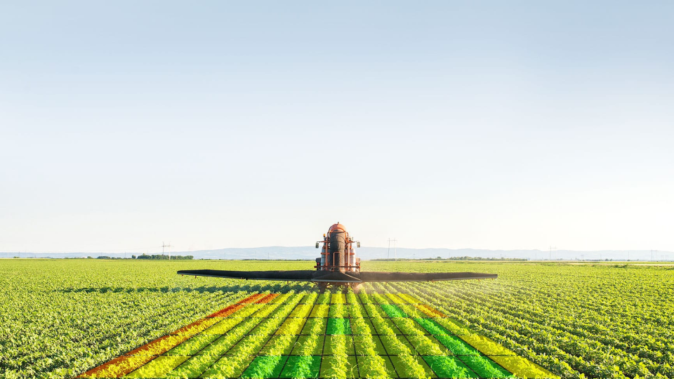
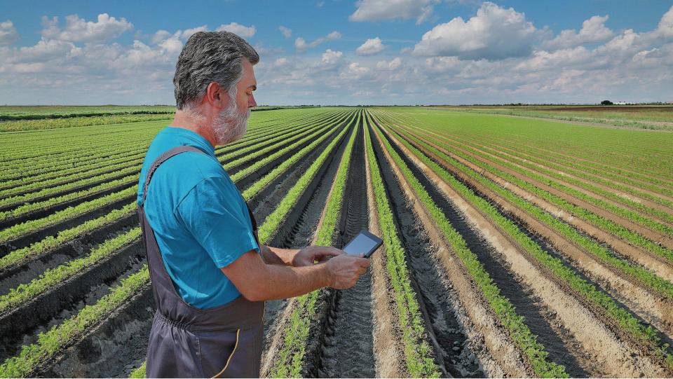
Transform your agricultural operations with the Solvi All-in-One Drone-Based Crop Monitoring Solution. Designed for efficiency and precision, this platform integrates cutting-edge tools for plant counts, health mapping, zonal statistics, and prescription file creation. Powered by PlantAI™, it provides fast, accurate insights that help farmers, agronomists, and researchers make data-driven decisions.
The platform supports diverse vegetation indices like NDVI and NDRE for in-depth analysis. Its intuitive tools streamline plot extraction, allow custom metrics, and generate ready-to-use prescription files with up to 1-meter resolution. Whether managing large farms or precision field trials, Solvi ensures efficiency with cloud-based processing and seamless integration with popular drones and sensors.
With flexible pricing plans and powerful features like ground control points, annotations, and collaboration tools, Solvi redefines crop monitoring, helping you enhance productivity and maximize yield.
Key Features
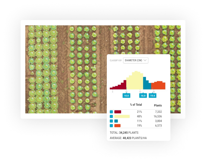
- PlantAI™ Analysis: Accurate plant counts and size estimates for diverse crops, trees, and vegetables.
- Zonal Statistics & Plot Tools: Advanced editing tools for field trials with easy Excel and SHP exports.
- Health Mapping: Identify field variations with vegetation indices and generate prescription files for fertilizers.
- Seamless Data Sharing: Collaborate with agronomists or clients using web links, annotations, and shared maps.
- Scalable Plans: Options for occasional data processing to enterprise-level drone imagery workflows.
Detailed Specification
Pay As You Go
| Feature | Details |
|---|---|
| Price | From $150 |
| Users | Single |
| Farms | Single |
| Uploads | 6 (up to 1500 captures) |
| Plant Counts | From $150 |
| Zonal Stats | No |
| Multispectral | No |
| Custom Branding | No |
| Onboarding Call | No |
| Permissions | No |
| API Integration | No |
Plan: Starter
| Feature | Details |
|---|---|
| Price | $999/year |
| Users | Single |
| Farms | Single |
| Uploads | 50 (20 extra/upload) |
| Plant Counts | $100 Credit |
| Zonal Stats | No |
| Multispectral | No |
| Custom Branding | No |
| Onboarding Call | No |
| Permissions | No |
| API Integration | No |
Plan: Professional
| Feature | Details |
|---|---|
| Price | $1999/year |
| Users | Single |
| Farms | Unlimited |
| Uploads | 120 (17 extra/upload) |
| Plant Counts | $200 Credit |
| Zonal Stats | Yes |
| Multispectral | Yes |
| Custom Branding | Yes |
| Onboarding Call | Yes |
| Permissions | No |
| API Integration | No |
Plan: Enterprise
| Feature | Details |
|---|---|
| Price | Contact Us |
| Users | Multiple |
| Farms | Unlimited |
| Uploads | 500 (14 extra/upload) |
| Plant Counts | $400 Credit |
| Zonal Stats | Yes |
| Multispectral | Yes |
| Custom Branding | Yes |
| Onboarding Call | Yes |
| Permissions | Yes |
| API Integration | Yes |
Add-On Features
PlantAI™ Plant Counts
- Basic Counts: $2.50/ha ($1.00/ac)
- Counts with Plant-Level Data: $5.00/ha ($2.00/ac)
Trial Plot Creation Tools
- Price: $599/year
- Generate plot boundaries and metrics like vegetation indices and plant counts.
Ground Control Points
- Price: $599/year
- Upload CSV files for accurate map georeferencing with 1–3 cm precision.
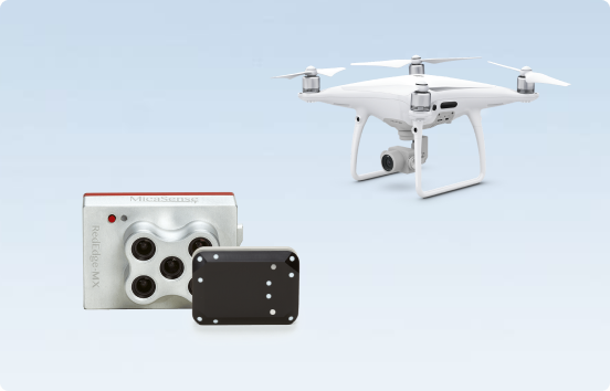
Supported Cameras
- RGB Cameras: DJI Phantom, DJI Mavic, and more.
- Multispectral Cameras: MicaSense RedEdge-M, Phantom 4 Multispectral, Sentera, and Slantrange.
In Package
- Access to Solvi’s Cloud-Based Processing and Analytics Platform
- Tools for Plant Health Mapping, Prescription Files, and Plot Analysis
- Integration with popular drones and sensors
- Collaboration Tools: Annotations, comments, and sharing options
Manuals & Documents
General Warranty Info:
- Ripping It Outdoors works closely with our manufacturers to supply and support your products warranty needs as best as possible!
- The majority of products come with a manufacturer represented warranty against manufacturing defects for at least a 12 month period after the date of sale.
- Expendable components and "wear parts" including but not limited to blades, knives, teeth, oil, chain sprockets, skid shoes, knife mounting discs, and similar components are usually excluded from manufacturer warranties.
- Please reach out to us for any specific warranty information needed about products and parts you can’t find!
Videos
Shipping
$1 Shipping Quote Info
- Contact Us For Shipping Quotes. All $1 products are listed as quote only because we can not display their pricing online.
- Low shipping rates for customers. We have negotiated the best possible rates for customers from our trusted carriers (ODFL, ESTES, UPS, and FedEx) & Top Private Drivers
- Negotiate shipping rates if you think we can do better please reach out. Keep in mind some shipping rates also include assembly & configuration as well!
- Complimentary lift gate service on all freight shipments where it’s possible. We guarantee safe delivery!