


eBee Geo Fixed-Wing Mapping Drone | 45-Min Flight | Area Coverage 395 Acres
eBee Geo Fixed-Wing Mapping Drone | 45-Min Flight | Area Coverage 395 Acres
Couldn't load pickup availability
Couldn't load pickup availability


How To Get A Quote
***Online pricing not available, Please request a quote:***
How To Get A Quote:
Option 1:
“Contact Us to make sure you are getting the best unit possible. These machines are complex so let us help you get exactly what you need!
Option 2: (quickest response times)
Step 1. Add the item to your cart
Step 2. Checkout or Click on the Chat button box that is at the bottom right of your screen
Step 3. Please tell us any info you think we would need to know
Step 4. Relax, our team is processing your request and an expert will be in touch to get you exactly what you need!
Product Description
eBee Geo Fixed-Wing Mapping Drone | 45-Min Flight | Area Coverage 395 Acres
DESCRIPTION
eBee Geo is a compact, cost-effective mapping solution tailored for surveyors, civil engineers, and GIS professionals. With an integrated senseFly S.O.D.A. RGB photogrammetry camera, 45-minute flight endurance, and optional RTK capability, it delivers absolute accuracy down to 2.5 cm / 1 in—without the need for GCPs.
This hand-launched, fully portable drone can be deployed solo in under 3 minutes, capturing high-resolution data across 160 hectares / 395 acres per flight. Its impact-tested underbelly made of reinforced polypropylene ensures reliable landings and operational durability. With full FMIS software compatibility and built-in FAA Remote ID, the eBee Geo is ready for advanced surveying missions across diverse terrains.
Key Features
- Flight Time: Up to 45 minutes with standard battery
- Coverage: Maps 160 ha / 395 ac at 120 m (400 ft) in one flight
- Camera: Built-in senseFly S.O.D.A. RGB, optimized for photogrammetry
- Accuracy: Down to 2.5 cm (1 in) with RTK enabled
- Deployment Time: 3-minute solo setup with hand-launch capability
- Lightweight Build: 1.3 kg / 2.2 lbs takeoff weight, compliant with global flight regulations
- Durable Design: Shock-absorbing woven mesh underbody for rugged terrain
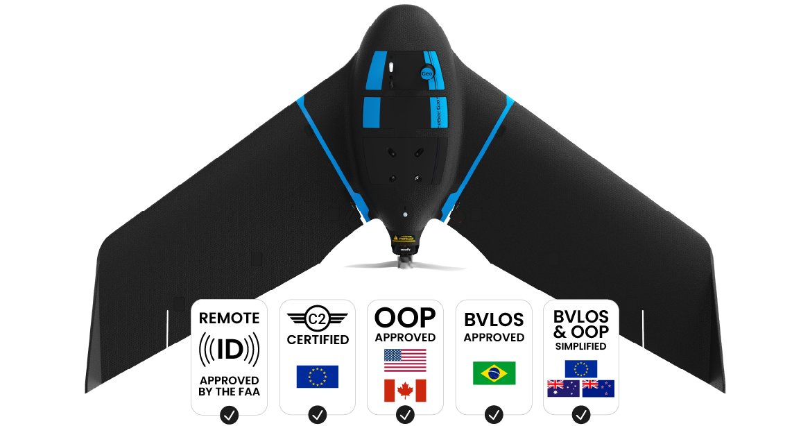
- Regulatory Compliance: FAA Remote ID, EU C2 Class, approved for OOP and BVLOS ops in select regions
- Software Compatibility: PIX4Dmapper, DroneDeploy, Esri Drone2Map, Agisoft Metashape, Trimble, SimActive, and more
- Accessories Included: S.O.D.A. camera, drone backpack, flight software, batteries, charger, USB ground modem, spare parts kit
| Flight Time | Coverage Area | Camera Type | Accuracy (RTK) | Takeoff Weight |
|---|---|---|---|---|
| Up to 45 minutes | 160 ha / 395 ac | senseFly S.O.D.A. (RGB Photogrammetry) | 2.5 cm / 1 in | 1.3 kg / 2.2 lbs |
Detailed Specifications
| Parameter | Specification |
|---|---|
| Camera | senseFly S.O.D.A., optimized RGB for photogrammetry |
| Flight Time | Up to 45 minutes |
| Coverage | 160 ha / 395 ac at 120 m / 400 ft |
| Accuracy | 2.5 cm / 1 in with RTK (no GCPs) |
| Takeoff Weight | 1.3 kg / 2.2 lbs |
| Deployment | Hand-launched | Solo operator | 3 min setup |
| Material | Reinforced polypropylene woven mesh underbody |
| Regulatory Compliance | FAA Remote ID, EU C2 class, BVLOS / OOP ready |
| Software Compatibility | PIX4D, DroneDeploy, ArcGIS, Trimble, Agisoft, SimActive |
| Safety Features | Integrated preflight checks, safe belly landings, no frontal motor |
| Portability | Drone backpack with laptop pocket and rain cover | 10 kg loaded |
| Accessories Included | S.O.D.A. camera, flight software, standard battery, charger, ground modem, spare props + pitot kit |
Manuals & Documents
General Warranty Info:
- Ripping It Outdoors works closely with our manufacturers to supply and support your products warranty needs as best as possible!
- The majority of products come with a manufacturer represented warranty against manufacturing defects for at least a 12 month period after the date of sale.
- Expendable components and "wear parts" including but not limited to blades, knives, teeth, oil, chain sprockets, skid shoes, knife mounting discs, and similar components are usually excluded from manufacturer warranties.
- Please reach out to us for any specific warranty information needed about products and parts you can’t find!
Videos
Shipping
$1 Shipping Quote Info:
- Contact Us For Shipping Quotes. All $1 products are listed as quote only because we can not display their pricing online.
- Low shipping rates for customers. We have negotiated the best possible rates for customers from our trusted carriers (ODFL, ESTES, UPS, and FedEx) & Top Private Drivers
- Negotiate shipping rates if you think we can do better please reach out. Keep in mind some shipping rates also include assembly & configuration as well!
- Complimentary lift gate service on all freight shipments where it’s possible. We guarantee safe delivery!